![](/images/other/stat-length.png)
![Tocht Stappen Mogán - Tauro - La Candelaria - LLanos de Balita - Barranco del Cura - Photo](https://media.geolcdn.com/t/1900/400/ext.pjpeg?maxdim=2&url=https%3A%2F%2Fstatic1.geolcdn.com%2Fsiteimages%2Fupload%2Ffiles%2F1553511878bg_sport_marche.png)
Tauro - La Candelaria - LLanos de Balita - Barranco del Cura
tonymeyer
Gebruiker
![Lengte](/images/other/stat-length.png)
![Max. hoogte](https://static1.geolcdn.com/siteimages/upload/files/1508320355ic_sort_altitude_max_24dp.png)
![Positief hoogteverschil](https://static1.geolcdn.com/siteimages/upload/files/1508320355ic_sort_den_pos_24dp.png)
![Km-Effort](/images/other/stat-length.png)
![Min. hoogte](https://static1.geolcdn.com/siteimages/upload/files/1508320355ic_sort_altitude_min_24dp.png)
![Negatief hoogteverschil](https://static1.geolcdn.com/siteimages/upload/files/1508320355ic_sort_den_neg_24dp.png)
![Boucle](https://static1.geolcdn.com/siteimages/upload/files/16400158638029165_repeat_loop_refresh_sync_direction_icon.png)
![Stappen](https://static1.geolcdn.com/sitytour/trail-icons/101.png)
2h30
Moeilijkheid : Gemakkelijk
![Scan deze QR-code om de tocht te openen in de SityTrail-applicatie](https://capi.geolives.com/qq0zvz2zws4bq2lad0pu/sitytour/trails/363708/qr.png?size=200)
Gratisgps-wandelapplicatie
Over ons
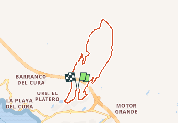
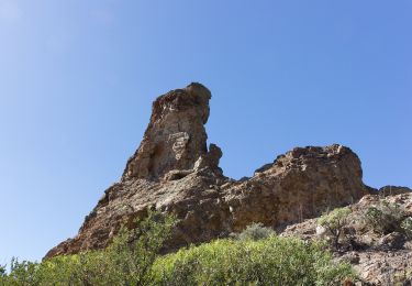
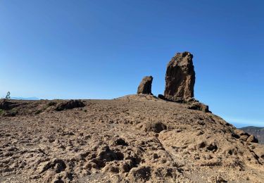
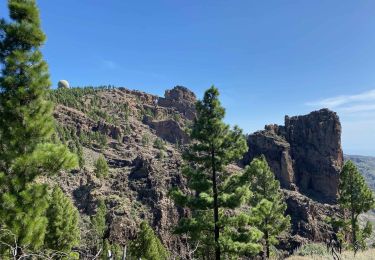
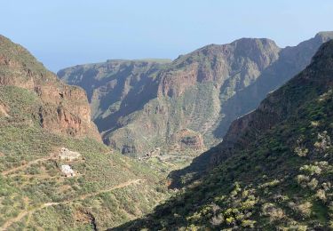
Tocht Stappen van 9,8 km beschikbaar op Canarische Eilanden, Las Palmas, Mogán. Deze tocht wordt voorgesteld door tonymeyer.
Beschrijving
Départ au terrain de pétanque de Tauro. Descendre dans l'agglomération (la route devient une allée) puis tourner à gauche pour commencer à monter le bras droite de "l'urbanisation". La route tourne à gauche, puis à droite, puis prendre une piste en terre battue qui monte d'abord à gauche, puis à droite. suivre ce sentier qui a des cairns jusqu'à la gravière. Continuer devant en montant pour suivre les cairns jusqu'au prochain plateau (457m altitude).
Quitter le sentier pour rejoindre une piste qui traverse en tournant à gauche. Descendre le barranco jusqu'au Golf. Sortir du Golf en tournant à gauche puis reprendre la route qui monte au terrain de pétanque.
Plaatsbepaling
Opmerkingen
Wandeltochten in de omgeving
![Tocht Te voet San Bartolomé de Tirajana - SLCC Chira - Cruz Grande - Photo](https://media.geolcdn.com/t/375/260/3067de9c-a0e0-4d99-ac43-40c01f10e3cd.jpeg&format=jpg&maxdim=2)
![Te voet Te voet](https://static1.geolcdn.com/sitytour/trail-icons/100.png)
Te voet
![](/images/other/stat-length.png)
![](https://static1.geolcdn.com/siteimages/upload/files/16400158638029165_repeat_loop_refresh_sync_direction_icon.png)
![Tocht Stappen San Bartolomé de Tirajana - Gran Canaria-San Bartolome 04-05-2017 - Photo](https://media.geolcdn.com/t/375/260/ext.jpg?maxdim=2&url=https%3A%2F%2Fstatic1.geolcdn.com%2Fsiteimages%2Fupload%2Ffiles%2F1553511878bg_sport_marche.png)
![Stappen Stappen](https://static1.geolcdn.com/sitytour/trail-icons/101.png)
Stappen
![](/images/other/stat-length.png)
![](https://static1.geolcdn.com/siteimages/upload/files/16400158638029165_repeat_loop_refresh_sync_direction_icon.png)
![Tocht Stappen Tejeda - Roque Nublo (Gran Canaria) - Photo](https://media.geolcdn.com/t/375/260/1b9ffdcd-5b17-4fe3-8fab-f075c0d4fd91.jpeg&format=jpg&maxdim=2)
![Stappen Stappen](https://static1.geolcdn.com/sitytour/trail-icons/101.png)
Stappen
![](/images/other/stat-length.png)
![](https://static1.geolcdn.com/siteimages/upload/files/16400158638029165_repeat_loop_refresh_sync_direction_icon.png)
![Tocht Stappen Tejeda - Pico de las Nieves (Gran Canaria) - Photo](https://media.geolcdn.com/t/375/260/8dd77f34-f9e0-4210-a8bf-aeffb88a20d1.jpeg&format=jpg&maxdim=2)
![Stappen Stappen](https://static1.geolcdn.com/sitytour/trail-icons/101.png)
Stappen
![](/images/other/stat-length.png)
![](https://static1.geolcdn.com/siteimages/upload/files/16400158638029165_repeat_loop_refresh_sync_direction_icon.png)
![Tocht Stappen Ingenio - Barranco de Guayadeque (Gran Canaria) - Photo](https://media.geolcdn.com/t/375/260/0ae8eaae-9d0c-41c2-aaed-1d8d51004d0c.jpeg&format=jpg&maxdim=2)
![Stappen Stappen](https://static1.geolcdn.com/sitytour/trail-icons/101.png)
Stappen
![](/images/other/stat-length.png)
![](https://static1.geolcdn.com/siteimages/upload/files/16400158638029165_repeat_loop_refresh_sync_direction_icon.png)
![Tocht Stappen San Bartolomé de Tirajana - Les dunes de Maspalomas (Gran Canaria) - Photo](https://media.geolcdn.com/t/375/260/48960093-93ab-47a7-9967-fb29d928079d.jpeg&format=jpg&maxdim=2)
![Stappen Stappen](https://static1.geolcdn.com/sitytour/trail-icons/101.png)
Stappen
![](/images/other/stat-length.png)
![](https://static1.geolcdn.com/siteimages/upload/files/16400158638029165_repeat_loop_refresh_sync_direction_icon.png)
![Tocht Te voet Mogán - Circular Venguera - Photo](https://media.geolcdn.com/t/375/260/1668a46a-b3b7-4321-a883-3c8a42337dae.jpeg&format=jpg&maxdim=2)
![Te voet Te voet](https://static1.geolcdn.com/sitytour/trail-icons/100.png)
Te voet
![](/images/other/stat-length.png)
![](https://static1.geolcdn.com/siteimages/upload/files/16400158638029165_repeat_loop_refresh_sync_direction_icon.png)
![Tocht Stappen San Bartolomé de Tirajana - phare de maspalomas - Photo](https://media.geolcdn.com/t/375/260/ff459a44-b678-4a4a-a9ec-994dc3492faf.jpg&format=jpg&maxdim=2)
![Stappen Stappen](https://static1.geolcdn.com/sitytour/trail-icons/101.png)
Stappen
![](/images/other/stat-length.png)
![](https://static1.geolcdn.com/siteimages/upload/files/16400158638029165_repeat_loop_refresh_sync_direction_icon.png)
![Tocht Stappen Tejeda - Roque mublo - Photo](https://media.geolcdn.com/t/375/260/39fb82ac-b00e-457f-b922-27428aa1fc7c.jpg&format=jpg&maxdim=2)
![Stappen Stappen](https://static1.geolcdn.com/sitytour/trail-icons/101.png)
Stappen
![](/images/other/stat-length.png)
![](https://static1.geolcdn.com/siteimages/upload/files/16400158638029165_repeat_loop_refresh_sync_direction_icon.png)