![](/images/other/stat-length.png)
![Tocht Paardrijden Westhoffen - 2023-04-23 Picnic CVA La Mercière depuis Westhoffen - Photo](https://media.geolcdn.com/t/1900/400/58786be0-7b72-4d94-ad0c-17bc65648da7.jpg&format=pjpeg&maxdim=2)
2023-04-23 Picnic CVA La Mercière depuis Westhoffen
holtzv
Gebruiker GUIDE
![Lengte](/images/other/stat-length.png)
![Max. hoogte](https://static1.geolcdn.com/siteimages/upload/files/1508320355ic_sort_altitude_max_24dp.png)
![Positief hoogteverschil](https://static1.geolcdn.com/siteimages/upload/files/1508320355ic_sort_den_pos_24dp.png)
![Km-Effort](/images/other/stat-length.png)
![Min. hoogte](https://static1.geolcdn.com/siteimages/upload/files/1508320355ic_sort_altitude_min_24dp.png)
![Negatief hoogteverschil](https://static1.geolcdn.com/siteimages/upload/files/1508320355ic_sort_den_neg_24dp.png)
![Boucle](https://static1.geolcdn.com/siteimages/upload/files/16400158638029165_repeat_loop_refresh_sync_direction_icon.png)
![Paardrijden](https://static1.geolcdn.com/sitytour/trail-icons/301.png)
5h28
Moeilijkheid : Medium
![Scan deze QR-code om de tocht te openen in de SityTrail-applicatie](https://capi.geolives.com/qq0zvz2zws4bq2lad0pu/sitytour/trails/3632638/qr.png?size=200)
Gratisgps-wandelapplicatie
Over ons
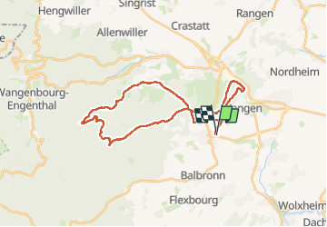
Tocht Paardrijden van 31 km beschikbaar op Grand Est, Bas-Rhin, Westhoffen. Deze tocht wordt voorgesteld door holtzv.
Beschrijving
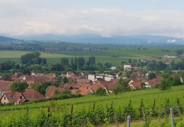
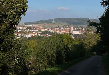
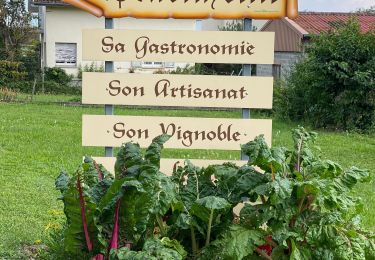
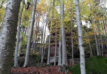
Boucle à la journée depuis Westhoffen pour profiter des passages ouverts offrant de belles vues sur les villages environnants ainsi que des forêts aux chemins sinueux, le tout en passant par la gloriette du Geierstein, le relais du Geisweg, la M.F. du Bischofslaeger, l’abri Schantz, et la colline du Wangenberg. Déjeuner au bistrot la Mercière à Cosswiller possédant des barres d’attaches pour le chevaux.
Plaatsbepaling
Opmerkingen
Wandeltochten in de omgeving
![Tocht Stappen Wolxheim - wolxheim, chapelle st-denis. - Photo](https://media.geolcdn.com/t/375/260/ext.jpg?maxdim=2&url=https%3A%2F%2Fservices.sitytrail.com%2FGeolivesWS%2FDownloadMedia.ashx%3FTrailID%3D212187%26Media%3D20130505140350.jpeg)
![Stappen Stappen](https://static1.geolcdn.com/sitytour/trail-icons/101.png)
Stappen
![](/images/other/stat-length.png)
![](https://static1.geolcdn.com/siteimages/upload/files/16400158638029165_repeat_loop_refresh_sync_direction_icon.png)
![Tocht Stappen Romanswiller - 2024-04-17_12h28m12_F2 - Photo](https://media.geolcdn.com/t/375/260/ext.jpg?maxdim=2&url=https%3A%2F%2Fstatic1.geolcdn.com%2Fsiteimages%2Fupload%2Ffiles%2F1553511878bg_sport_marche.png)
![Stappen Stappen](https://static1.geolcdn.com/sitytour/trail-icons/101.png)
Stappen
![](/images/other/stat-length.png)
![](https://static1.geolcdn.com/siteimages/upload/files/16400158638029165_repeat_loop_refresh_sync_direction_icon.png)
![Tocht Noords wandelen Bergbieten - Bergbieten 20240307 - Photo](https://media.geolcdn.com/t/375/260/26097aee-bf2f-412f-a04a-fb741c704d07.jpg&format=jpg&maxdim=2)
![Noords wandelen Noords wandelen](https://static1.geolcdn.com/sitytour/trail-icons/102.png)
Noords wandelen
![](/images/other/stat-length.png)
![](https://static1.geolcdn.com/siteimages/upload/files/16400158638029165_repeat_loop_refresh_sync_direction_icon.png)
![Tocht Stappen Nordheim - Nordheim 20240224 - Photo](https://media.geolcdn.com/t/375/260/6330086d-dc82-440a-bc76-484527f9dd0f.jpg&format=jpg&maxdim=2)
![Stappen Stappen](https://static1.geolcdn.com/sitytour/trail-icons/101.png)
Stappen
![](/images/other/stat-length.png)
![](https://static1.geolcdn.com/siteimages/upload/files/16400158638029165_repeat_loop_refresh_sync_direction_icon.png)
![Tocht Noords wandelen Nordheim - Nordheim 20220605 - Photo](https://media.geolcdn.com/t/375/260/aed5eb9f-a56f-46f2-8421-c2eed3cd4a7e.jpg&format=jpg&maxdim=2)
![Noords wandelen Noords wandelen](https://static1.geolcdn.com/sitytour/trail-icons/102.png)
Noords wandelen
![](/images/other/stat-length.png)
![](https://static1.geolcdn.com/siteimages/upload/files/16400158638029165_repeat_loop_refresh_sync_direction_icon.png)
![Tocht Elektrische fiets Scharrachbergheim-Irmstett - Schrrachbergheim - COL des Pandours - Photo](https://media.geolcdn.com/t/375/260/1e66d6f3-942a-4a19-b046-173c19ed20a6.jpg&format=jpg&maxdim=2)
![Elektrische fiets Elektrische fiets](https://static1.geolcdn.com/sitytour/trail-icons/205.png)
Elektrische fiets
![](/images/other/stat-length.png)
![](https://static1.geolcdn.com/siteimages/upload/files/16400158638029165_repeat_loop_refresh_sync_direction_icon.png)
![Tocht Elektrische fiets Scharrachbergheim-Irmstett - Place des Pandours - Photo](https://media.geolcdn.com/t/375/260/d8f211c7-c25c-4d86-82d6-f12a9680ffeb.jpg&format=jpg&maxdim=2)
![Elektrische fiets Elektrische fiets](https://static1.geolcdn.com/sitytour/trail-icons/205.png)
Elektrische fiets
![](/images/other/stat-length.png)
![](https://static1.geolcdn.com/siteimages/upload/files/16400158638029165_repeat_loop_refresh_sync_direction_icon.png)
![Tocht Stappen Wangen - , westhoffen - Photo](https://media.geolcdn.com/t/375/260/b175c1a5-0734-47ef-bc29-135efa0b24c4.jpg&format=jpg&maxdim=2)
![Stappen Stappen](https://static1.geolcdn.com/sitytour/trail-icons/101.png)
![Tocht Stappen Still - ancien. lavoir balbronn - Photo](https://media.geolcdn.com/t/375/260/ba0361b4-71f6-40fe-a564-cffaa62d3263.jpg&format=jpg&maxdim=2)
![Stappen Stappen](https://static1.geolcdn.com/sitytour/trail-icons/101.png)
Stappen
![](/images/other/stat-length.png)
![](https://static1.geolcdn.com/siteimages/upload/files/16400158638029165_repeat_loop_refresh_sync_direction_icon.png)