![](/images/other/stat-length.png)
![Tocht Stappen Aat - ATH _ Marche Fédérale _ HT _23/04/2023 - Photo](https://media.geolcdn.com/t/1900/400/ext.pjpeg?maxdim=2&url=https%3A%2F%2Fstatic1.geolcdn.com%2Fsiteimages%2Fupload%2Ffiles%2F1553511878bg_sport_marche.png)
ATH _ Marche Fédérale _ HT _23/04/2023
jeangulu
Gebruiker
![Lengte](/images/other/stat-length.png)
Lengte
10,7 km
![Max. hoogte](https://static1.geolcdn.com/siteimages/upload/files/1508320355ic_sort_altitude_max_24dp.png)
Max. hoogte
45 m
![Positief hoogteverschil](https://static1.geolcdn.com/siteimages/upload/files/1508320355ic_sort_den_pos_24dp.png)
Positief hoogteverschil
55 m
![Km-Effort](/images/other/stat-length.png)
Km-Effort
11,4 km
![Min. hoogte](https://static1.geolcdn.com/siteimages/upload/files/1508320355ic_sort_altitude_min_24dp.png)
Min. hoogte
24 m
![Negatief hoogteverschil](https://static1.geolcdn.com/siteimages/upload/files/1508320355ic_sort_den_neg_24dp.png)
Negatief hoogteverschil
56 m
![Boucle](https://static1.geolcdn.com/siteimages/upload/files/16400158638029165_repeat_loop_refresh_sync_direction_icon.png)
Boucle
Ja
Datum van aanmaak :
2023-04-23 09:36:29.914
Laatste wijziging :
2023-04-23 12:14:26.342
![Stappen](https://static1.geolcdn.com/sitytour/trail-icons/101.png)
2h37
Moeilijkheid : Medium
![Scan deze QR-code om de tocht te openen in de SityTrail-applicatie](https://capi.geolives.com/qq0zvz2zws4bq2lad0pu/sitytour/trails/3632201/qr.png?size=200)
Gratisgps-wandelapplicatie
Over ons
Tocht Stappen van 10,7 km beschikbaar op Wallonië, Henegouwen, Aat. Deze tocht wordt voorgesteld door jeangulu.
Beschrijving
Point de départ : Collège Saint Julien _ Rue du Spectacle 17 _ 7800 ATH.
Organisateur : HT 004 _ LES AMIS DE LA NATURE ATH ASBL.
Carte IGN :38/6.
50' Marche internationale du Pays Vert.
Déçu de cette Marche.
Plaatsbepaling
Land:
Belgium
Regio :
Wallonië
Departement/Provincie :
Henegouwen
Gemeente :
Aat
Locatie:
Aat (deelgemeente)
Vertrek:(Dec)
Vertrek:(UTM)
555076 ; 5608739 (31U) N.
Opmerkingen
Wandeltochten in de omgeving
![Tocht Stappen Aat - GG2-Ha-26_Ath-Erbisoeul_2021-11-04 - Photo](https://media.geolcdn.com/t/375/260/ext.jpg?maxdim=2&url=https%3A%2F%2Fmedia.geolcdn.com%2Ff%2F92330c27-b822-40ac-9b26-3b2e2e0e14fe.jpg)
![Stappen Stappen](https://static1.geolcdn.com/sitytour/trail-icons/101.png)
GG2-Ha-26_Ath-Erbisoeul_2021-11-04
Stappen
Medium
(1)
Aat,
Wallonië,
Henegouwen,
Belgium
![](/images/other/stat-length.png)
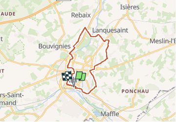
24 km | 26 km-effort
5h 59min
![](https://static1.geolcdn.com/siteimages/upload/files/16400158638029165_repeat_loop_refresh_sync_direction_icon.png)
Neen
![Tocht Te voet Aat - Kastelenroute - Photo](https://media.geolcdn.com/t/375/260/ext.jpg?maxdim=2&url=https%3A%2F%2Fpivotmedia.tourismewallonie.be%2FANX-02-04JL-028B%2FANX-02-04JL-028B.JPG)
![Te voet Te voet](https://static1.geolcdn.com/sitytour/trail-icons/100.png)
Kastelenroute
Te voet
Gemakkelijk
Aat,
Wallonië,
Henegouwen,
Belgium
![](/images/other/stat-length.png)
15 km | 16,5 km-effort
3h 45min
![](https://static1.geolcdn.com/siteimages/upload/files/16400158638029165_repeat_loop_refresh_sync_direction_icon.png)
Ja
![Tocht Te voet Aat - In de voetsporen van de steenhouwers - Photo](https://media.geolcdn.com/t/375/260/ext.jpg?maxdim=2&url=https%3A%2F%2Fpivotmedia.tourismewallonie.be%2FANX-02-04JL-01MH%2FANX-02-04JL-01MH.jpg)
![Te voet Te voet](https://static1.geolcdn.com/sitytour/trail-icons/100.png)
In de voetsporen van de steenhouwers
Te voet
Gemakkelijk
Aat,
Wallonië,
Henegouwen,
Belgium
![](/images/other/stat-length.png)
3,3 km | 3,6 km-effort
49min
![](https://static1.geolcdn.com/siteimages/upload/files/16400158638029165_repeat_loop_refresh_sync_direction_icon.png)
Ja
![Tocht Te voet Aat - Circuit van de Dendervlakte - Photo](https://media.geolcdn.com/t/375/260/ext.jpg?maxdim=2&url=https%3A%2F%2Fpivotmedia.tourismewallonie.be%2FANX-02-000ESY%2FANX-02-000ESY.jpg)
![Te voet Te voet](https://static1.geolcdn.com/sitytour/trail-icons/100.png)
Circuit van de Dendervlakte
Te voet
Gemakkelijk
Aat,
Wallonië,
Henegouwen,
Belgium
![](/images/other/stat-length.png)
8,9 km | 9,7 km-effort
2h 12min
![](https://static1.geolcdn.com/siteimages/upload/files/16400158638029165_repeat_loop_refresh_sync_direction_icon.png)
Ja
![Tocht Te voet Aat - Het Kapellencircuit - Photo](https://media.geolcdn.com/t/375/260/ext.jpg?maxdim=2&url=https%3A%2F%2Fpivotmedia.tourismewallonie.be%2FANX-02-000EST%2FANX-02-000EST.jpg)
![Te voet Te voet](https://static1.geolcdn.com/sitytour/trail-icons/100.png)
Het Kapellencircuit
Te voet
Gemakkelijk
Aat,
Wallonië,
Henegouwen,
Belgium
![](/images/other/stat-length.png)
11,1 km | 12,3 km-effort
2h 47min
![](https://static1.geolcdn.com/siteimages/upload/files/16400158638029165_repeat_loop_refresh_sync_direction_icon.png)
Ja
![Tocht Elektrische fiets Aat - Entre la cité des géants et le château de Beloeil - Photo](https://media.geolcdn.com/t/375/260/ext.jpg?maxdim=2&url=https%3A%2F%2Fmedia.geolcdn.com%2Ff%2Fd42d3fbb-98cc-4c8a-abd4-2d757f22feb5.jpg)
![Elektrische fiets Elektrische fiets](https://static1.geolcdn.com/sitytour/trail-icons/205.png)
Entre la cité des géants et le château de Beloeil
Elektrische fiets
Gemakkelijk
Aat,
Wallonië,
Henegouwen,
Belgium
![](/images/other/stat-length.png)
41 km | 45 km-effort
2h 53min
![](https://static1.geolcdn.com/siteimages/upload/files/16400158638029165_repeat_loop_refresh_sync_direction_icon.png)
Ja
![Tocht Stappen Aat - MESLIN-L'ÉVÊQUE _ ( Ath ) _ Marche Adeps _ HT_ 12/02/2023 - Photo](https://media.geolcdn.com/t/375/260/ext.jpg?maxdim=2&url=https%3A%2F%2Fmedia.geolcdn.com%2Ff%2Fdff039e6-7dea-4336-a476-dde092f02ebd.jpg)
![Stappen Stappen](https://static1.geolcdn.com/sitytour/trail-icons/101.png)
MESLIN-L'ÉVÊQUE _ ( Ath ) _ Marche Adeps _ HT_ 12/02/2023
Stappen
Medium
Aat,
Wallonië,
Henegouwen,
Belgium
![](/images/other/stat-length.png)
20 km | 22 km-effort
4h 42min
![](https://static1.geolcdn.com/siteimages/upload/files/16400158638029165_repeat_loop_refresh_sync_direction_icon.png)
Ja
![Tocht Stappen Aat - Ath FFBMP - Photo](https://media.geolcdn.com/t/375/260/ext.jpg?maxdim=2&url=https%3A%2F%2Fmedia.geolcdn.com%2Ff%2F09b382b0-6366-435d-8c9c-8a17083a918b.jpg)
![Stappen Stappen](https://static1.geolcdn.com/sitytour/trail-icons/101.png)
![Tocht Stappen Aat - Marche 2023 20km - Photo](https://media.geolcdn.com/t/375/260/ext.jpg?maxdim=2&url=https%3A%2F%2Fstatic1.geolcdn.com%2Fsiteimages%2Fupload%2Ffiles%2F1553511878bg_sport_marche.png)
![Stappen Stappen](https://static1.geolcdn.com/sitytour/trail-icons/101.png)
Marche 2023 20km
Stappen
Heel gemakkelijk
(1)
Aat,
Wallonië,
Henegouwen,
Belgium
![](/images/other/stat-length.png)
19,4 km | 24 km-effort
5h 0min
![](https://static1.geolcdn.com/siteimages/upload/files/16400158638029165_repeat_loop_refresh_sync_direction_icon.png)
Ja