![](/images/other/stat-length.png)
![Tocht Paard Hanvec - Menez-Meur -> Saint-Rivoal -> Braspart -> Lac du Drennec - Photo](https://media.geolcdn.com/t/1900/400/ext.pjpeg?maxdim=2&url=https%3A%2F%2Fstatic1.geolcdn.com%2Fsiteimages%2Fupload%2Ffiles%2F1524743154cheval.jpg)
Menez-Meur -> Saint-Rivoal -> Braspart -> Lac du Drennec
![Lengte](/images/other/stat-length.png)
![Max. hoogte](https://static1.geolcdn.com/siteimages/upload/files/1508320355ic_sort_altitude_max_24dp.png)
![Positief hoogteverschil](https://static1.geolcdn.com/siteimages/upload/files/1508320355ic_sort_den_pos_24dp.png)
![Km-Effort](/images/other/stat-length.png)
![Min. hoogte](https://static1.geolcdn.com/siteimages/upload/files/1508320355ic_sort_altitude_min_24dp.png)
![Negatief hoogteverschil](https://static1.geolcdn.com/siteimages/upload/files/1508320355ic_sort_den_neg_24dp.png)
![Boucle](https://static1.geolcdn.com/siteimages/upload/files/16400158638029165_repeat_loop_refresh_sync_direction_icon.png)
![Paard](https://static1.geolcdn.com/sitytour/trail-icons/300.png)
0m
Moeilijkheid : Zeer moeilijk
![Scan deze QR-code om de tocht te openen in de SityTrail-applicatie](https://capi.geolives.com/qq0zvz2zws4bq2lad0pu/sitytour/trails/3631858/qr.png?size=200)
Gratisgps-wandelapplicatie
Over ons
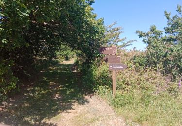
Tocht Paard van 33 km beschikbaar op Bretagne, Finistère, Hanvec. Deze tocht wordt voorgesteld door 000134.4abf8d98f60b4f1fa78c45da360fe973.1207.
Beschrijving
Randonnée étudiée pour préparer des chevaux à l'endurance avec beaucoup de dénivelés mais abordable pour des chevaux en bonne très condition physique.
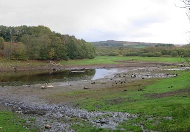
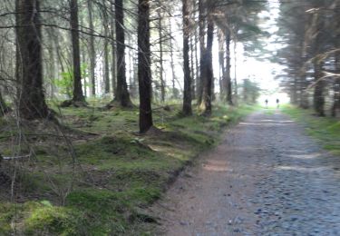
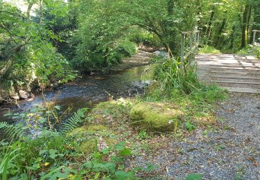
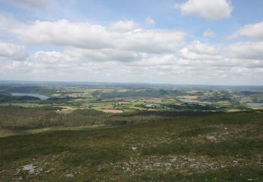
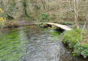
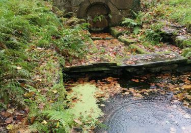
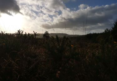
Forêt dense et sauvage, bord de rivière, landes, points de vue remarquables, petit village Breton et bord de lac.
Nécessité d'avoir une équipe d'assistance.
Attention : chevaux ferrés (voir plaqué) ou chaussés avec hipposandales épaisses -> beaucoup de chemin en gros cailloux pointus du côté de Braspart.
Programme de visites prévu à l'attention de l'équipe d'assistance (vérifier les horaires d'ouverture à l'avance) : Parc animalier de Menez Meur, écomusée de Saint-Rivoal, Braspart/ Lac du Drennec. Ok pour enfants dans l'équipe d'assistance.
POI's
Plaatsbepaling
Opmerkingen
Wandeltochten in de omgeving
![Tocht Te voet Commana - Tour du Lac du Drennec - Photo](https://media.geolcdn.com/t/375/260/217e9b5b-dfd1-47dd-bef6-7dae7db515fe.jpeg&format=jpg&maxdim=2)
![Te voet Te voet](https://static1.geolcdn.com/sitytour/trail-icons/100.png)
Te voet
![](/images/other/stat-length.png)
![](https://static1.geolcdn.com/siteimages/upload/files/16400158638029165_repeat_loop_refresh_sync_direction_icon.png)
![Stappen Stappen](https://static1.geolcdn.com/sitytour/trail-icons/101.png)
Stappen
![](/images/other/stat-length.png)
![](https://static1.geolcdn.com/siteimages/upload/files/16400158638029165_repeat_loop_refresh_sync_direction_icon.png)
![Tocht Stappen Saint-Rivoal - GR_37_FA_12_St-Rivoal_Loperec_20200811 - Photo](https://media.geolcdn.com/t/375/260/f5ace299-8c7f-44c6-82e9-6da866129eef.jpg&format=jpg&maxdim=2)
![Stappen Stappen](https://static1.geolcdn.com/sitytour/trail-icons/101.png)
Stappen
![](/images/other/stat-length.png)
![](https://static1.geolcdn.com/siteimages/upload/files/16400158638029165_repeat_loop_refresh_sync_direction_icon.png)
![Tocht Paard Saint-Rivoal - Autour de St Rivoal par le lac du Drennec - Photo](https://media.geolcdn.com/t/375/260/ext.jpg?maxdim=2&url=https%3A%2F%2Fservices.sitytrail.com%2FGeolivesWS%2FDownloadMedia.ashx%3FTrailID%3D317263%26Media%3D16448_6.jpg)
![Paard Paard](https://static1.geolcdn.com/sitytour/trail-icons/300.png)
Paard
![](/images/other/stat-length.png)
![](https://static1.geolcdn.com/siteimages/upload/files/16400158638029165_repeat_loop_refresh_sync_direction_icon.png)
![Tocht Noords wandelen Saint-Eloy - circuit de Ménez meur - Photo](https://media.geolcdn.com/t/375/260/2d1a9a37-eda7-462e-8826-49ca3b8de375.jpg&format=jpg&maxdim=2)
![Noords wandelen Noords wandelen](https://static1.geolcdn.com/sitytour/trail-icons/102.png)
Noords wandelen
![](/images/other/stat-length.png)
![](https://static1.geolcdn.com/siteimages/upload/files/16400158638029165_repeat_loop_refresh_sync_direction_icon.png)
![Tocht Stappen Sizun - SAINT CADOU - Photo](https://media.geolcdn.com/t/375/260/fef4f49b-990f-4a0a-b8a9-f239bc0349c0.jpg&format=jpg&maxdim=2)
![Stappen Stappen](https://static1.geolcdn.com/sitytour/trail-icons/101.png)
![Tocht Stappen Sizun - st cadou les carrieres - Photo](https://media.geolcdn.com/t/375/260/5d7228d4-6a1f-4a10-b8d6-e1a199ab0f3f.jpg&format=jpg&maxdim=2)
![Stappen Stappen](https://static1.geolcdn.com/sitytour/trail-icons/101.png)
Stappen
![](/images/other/stat-length.png)
![](https://static1.geolcdn.com/siteimages/upload/files/16400158638029165_repeat_loop_refresh_sync_direction_icon.png)
![Tocht Stappen Saint-Rivoal - st rivoal - Photo](https://media.geolcdn.com/t/375/260/e615d1db-b2ce-4a52-8cff-fd057e0ebecc.jpg&format=jpg&maxdim=2)
![Stappen Stappen](https://static1.geolcdn.com/sitytour/trail-icons/101.png)
Stappen
![](/images/other/stat-length.png)
![](https://static1.geolcdn.com/siteimages/upload/files/16400158638029165_repeat_loop_refresh_sync_direction_icon.png)
![Tocht Stappen Saint-Rivoal - st rivoual - Photo](https://media.geolcdn.com/t/375/260/c156942c-1f61-4e4f-bc3a-2d9786911435.jpg&format=jpg&maxdim=2)
![Stappen Stappen](https://static1.geolcdn.com/sitytour/trail-icons/101.png)
Stappen
![](/images/other/stat-length.png)
![](https://static1.geolcdn.com/siteimages/upload/files/16400158638029165_repeat_loop_refresh_sync_direction_icon.png)