![](/images/other/stat-length.png)
![Tocht Stappen Correns - gpx-trace CORRENS N4 - Photo](https://media.geolcdn.com/t/1900/400/ext.pjpeg?maxdim=2&url=https%3A%2F%2Fstatic1.geolcdn.com%2Fsiteimages%2Fupload%2Ffiles%2F1553511878bg_sport_marche.png)
gpx-trace CORRENS N4
azzogege
Gebruiker
![Lengte](/images/other/stat-length.png)
Lengte
15,7 km
![Max. hoogte](https://static1.geolcdn.com/siteimages/upload/files/1508320355ic_sort_altitude_max_24dp.png)
Max. hoogte
337 m
![Positief hoogteverschil](https://static1.geolcdn.com/siteimages/upload/files/1508320355ic_sort_den_pos_24dp.png)
Positief hoogteverschil
358 m
![Km-Effort](/images/other/stat-length.png)
Km-Effort
20 km
![Min. hoogte](https://static1.geolcdn.com/siteimages/upload/files/1508320355ic_sort_altitude_min_24dp.png)
Min. hoogte
160 m
![Negatief hoogteverschil](https://static1.geolcdn.com/siteimages/upload/files/1508320355ic_sort_den_neg_24dp.png)
Negatief hoogteverschil
358 m
![Boucle](https://static1.geolcdn.com/siteimages/upload/files/16400158638029165_repeat_loop_refresh_sync_direction_icon.png)
Boucle
Ja
Datum van aanmaak :
2023-04-21 05:41:37.133
Laatste wijziging :
2024-03-10 14:09:57.796
![Stappen](https://static1.geolcdn.com/sitytour/trail-icons/101.png)
4h39
Moeilijkheid : Zeer moeilijk
![Scan deze QR-code om de tocht te openen in de SityTrail-applicatie](https://capi.geolives.com/qq0zvz2zws4bq2lad0pu/sitytour/trails/3629409/qr.png?size=200)
Gratisgps-wandelapplicatie
Over ons
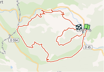
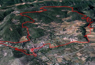
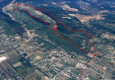
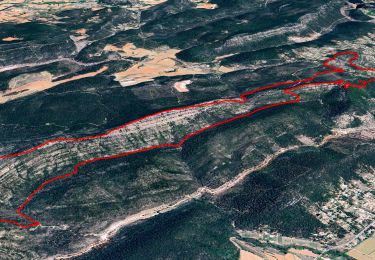
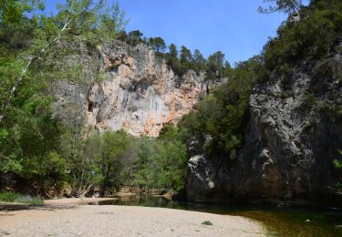
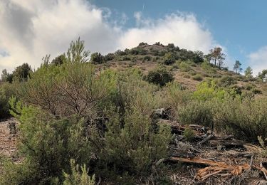
Tocht Stappen van 15,7 km beschikbaar op Provence-Alpes-Côte d'Azur, Var, Correns. Deze tocht wordt voorgesteld door azzogege.
Beschrijving
trace corrige passant au depart par le chemin faisant decouvrir le village et le fort GIBRON et reprise de l'itineraire par le trace original et passage par la grotte de sous ville
Plaatsbepaling
Land:
France
Regio :
Provence-Alpes-Côte d'Azur
Departement/Provincie :
Var
Gemeente :
Correns
Locatie:
Unknown
Vertrek:(Dec)
Vertrek:(UTM)
263913 ; 4818937 (32T) N.
Opmerkingen
Wandeltochten in de omgeving
![Tocht Stappen Correns - Le patrimoine - l'Argens - Le village - Photo](https://media.geolcdn.com/t/375/260/405a713c-9f67-402a-9b2f-998d4bced48b.jpg&format=jpg&maxdim=2)
![Stappen Stappen](https://static1.geolcdn.com/sitytour/trail-icons/101.png)
Le patrimoine - l'Argens - Le village
Stappen
Gemakkelijk
(2)
Correns,
Provence-Alpes-Côte d'Azur,
Var,
France
![](/images/other/stat-length.png)
14,2 km | 18,1 km-effort
6h 0min
![](https://static1.geolcdn.com/siteimages/upload/files/16400158638029165_repeat_loop_refresh_sync_direction_icon.png)
Ja
![Tocht Stappen Le Val - Trace_Le_Val - Photo](https://media.geolcdn.com/t/375/260/ad8ed400-7110-4a48-9445-b211f10f638d.jpg&format=jpg&maxdim=2)
![Stappen Stappen](https://static1.geolcdn.com/sitytour/trail-icons/101.png)
Trace_Le_Val
Stappen
Medium
(1)
Le Val,
Provence-Alpes-Côte d'Azur,
Var,
France
![](/images/other/stat-length.png)
14,6 km | 21 km-effort
6h 0min
![](https://static1.geolcdn.com/siteimages/upload/files/16400158638029165_repeat_loop_refresh_sync_direction_icon.png)
Ja
![Tocht Stappen Le Val - Le Mont Cuit par la Grande Muraille - Photo](https://media.geolcdn.com/t/375/260/9fec4f0b-b6f3-462f-8d34-0edd3ef3698e.jpg&format=jpg&maxdim=2)
![Stappen Stappen](https://static1.geolcdn.com/sitytour/trail-icons/101.png)
Le Mont Cuit par la Grande Muraille
Stappen
Medium
(1)
Le Val,
Provence-Alpes-Côte d'Azur,
Var,
France
![](/images/other/stat-length.png)
14 km | 21 km-effort
6h 0min
![](https://static1.geolcdn.com/siteimages/upload/files/16400158638029165_repeat_loop_refresh_sync_direction_icon.png)
Ja
![Stappen Stappen](https://static1.geolcdn.com/sitytour/trail-icons/101.png)
Correns - Val Obscur - Rive de l'Argens - Grotte aux Fées - Châteauvert - Val...
Stappen
Medium
Correns,
Provence-Alpes-Côte d'Azur,
Var,
France
![](/images/other/stat-length.png)
21 km | 27 km-effort
4h 57min
![](https://static1.geolcdn.com/siteimages/upload/files/16400158638029165_repeat_loop_refresh_sync_direction_icon.png)
Ja
![Tocht Stappen Le Val - circuit des chapelles-le Val-07-09-22 - Photo](https://media.geolcdn.com/t/375/260/44ac00a3-6144-4a54-9a47-ced322186cfc.jpg&format=jpg&maxdim=2)
![Stappen Stappen](https://static1.geolcdn.com/sitytour/trail-icons/101.png)
circuit des chapelles-le Val-07-09-22
Stappen
Medium
(1)
Le Val,
Provence-Alpes-Côte d'Azur,
Var,
France
![](/images/other/stat-length.png)
14,7 km | 22 km-effort
4h 12min
![](https://static1.geolcdn.com/siteimages/upload/files/16400158638029165_repeat_loop_refresh_sync_direction_icon.png)
Ja
![Tocht Stappen Correns - Correns-18-03-22 - Photo](https://media.geolcdn.com/t/375/260/09a33764-10f5-4925-96d0-198bf65221a1.jpg&format=jpg&maxdim=2)
![Stappen Stappen](https://static1.geolcdn.com/sitytour/trail-icons/101.png)
Correns-18-03-22
Stappen
Medium
Correns,
Provence-Alpes-Côte d'Azur,
Var,
France
![](/images/other/stat-length.png)
11,9 km | 14,9 km-effort
4h 10min
![](https://static1.geolcdn.com/siteimages/upload/files/16400158638029165_repeat_loop_refresh_sync_direction_icon.png)
Ja
![Tocht Stappen Le Val - Circuit des Chapelle-Le Val-15-01-21 - Photo](https://media.geolcdn.com/t/375/260/e4c20b6b-c67f-4f8a-9d83-5af46fcebc22.jpg&format=jpg&maxdim=2)
![Stappen Stappen](https://static1.geolcdn.com/sitytour/trail-icons/101.png)
Circuit des Chapelle-Le Val-15-01-21
Stappen
Medium
(1)
Le Val,
Provence-Alpes-Côte d'Azur,
Var,
France
![](/images/other/stat-length.png)
12,7 km | 18,1 km-effort
4h 29min
![](https://static1.geolcdn.com/siteimages/upload/files/16400158638029165_repeat_loop_refresh_sync_direction_icon.png)
Ja
![Tocht Stappen Le Val - Le Val : Le Cuit - Photo](https://media.geolcdn.com/t/375/260/ext.jpg?maxdim=2&url=https%3A%2F%2Fstatic1.geolcdn.com%2Fsiteimages%2Fupload%2Ffiles%2F1553511878bg_sport_marche.png)
![Stappen Stappen](https://static1.geolcdn.com/sitytour/trail-icons/101.png)
Le Val : Le Cuit
Stappen
Moeilijk
(1)
Le Val,
Provence-Alpes-Côte d'Azur,
Var,
France
![](/images/other/stat-length.png)
12,9 km | 19,8 km-effort
4h 7min
![](https://static1.geolcdn.com/siteimages/upload/files/16400158638029165_repeat_loop_refresh_sync_direction_icon.png)
Ja
![Tocht Mountainbike Correns - Correns à faire - Photo](https://media.geolcdn.com/t/375/260/6347d8bc-2d08-4062-9163-62c8d555de14.jpg&format=jpg&maxdim=2)
![Mountainbike Mountainbike](https://static1.geolcdn.com/sitytour/trail-icons/202.png)
Correns à faire
Mountainbike
Medium
Correns,
Provence-Alpes-Côte d'Azur,
Var,
France
![](/images/other/stat-length.png)
25 km | 32 km-effort
2h 55min
![](https://static1.geolcdn.com/siteimages/upload/files/16400158638029165_repeat_loop_refresh_sync_direction_icon.png)
Ja