![](/images/other/stat-length.png)
![Tocht Stappen Bussac - Bussac 2 revu AJC 10km - Photo](https://media.geolcdn.com/t/1900/400/ext.pjpeg?maxdim=2&url=https%3A%2F%2Fstatic1.geolcdn.com%2Fsiteimages%2Fupload%2Ffiles%2F1553511878bg_sport_marche.png)
Bussac 2 revu AJC 10km
YV24
Gebruiker
![Lengte](/images/other/stat-length.png)
Lengte
9,6 km
![Max. hoogte](https://static1.geolcdn.com/siteimages/upload/files/1508320355ic_sort_altitude_max_24dp.png)
Max. hoogte
202 m
![Positief hoogteverschil](https://static1.geolcdn.com/siteimages/upload/files/1508320355ic_sort_den_pos_24dp.png)
Positief hoogteverschil
196 m
![Km-Effort](/images/other/stat-length.png)
Km-Effort
12,2 km
![Min. hoogte](https://static1.geolcdn.com/siteimages/upload/files/1508320355ic_sort_altitude_min_24dp.png)
Min. hoogte
115 m
![Negatief hoogteverschil](https://static1.geolcdn.com/siteimages/upload/files/1508320355ic_sort_den_neg_24dp.png)
Negatief hoogteverschil
196 m
![Boucle](https://static1.geolcdn.com/siteimages/upload/files/16400158638029165_repeat_loop_refresh_sync_direction_icon.png)
Boucle
Ja
Datum van aanmaak :
2014-12-10 00:00:00.0
Laatste wijziging :
2022-12-19 16:07:02.685
![Stappen](https://static1.geolcdn.com/sitytour/trail-icons/101.png)
2h40
Moeilijkheid : Gemakkelijk
![Scan deze QR-code om de tocht te openen in de SityTrail-applicatie](https://capi.geolives.com/qq0zvz2zws4bq2lad0pu/sitytour/trails/362560/qr.png?size=200)
Gratisgps-wandelapplicatie
Over ons
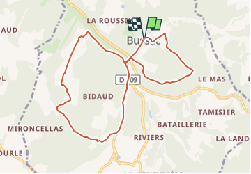
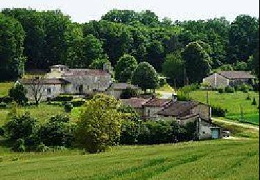
Tocht Stappen van 9,6 km beschikbaar op Nieuw-Aquitanië, Dordogne, Bussac. Deze tocht wordt voorgesteld door YV24.
Beschrijving
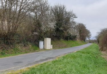
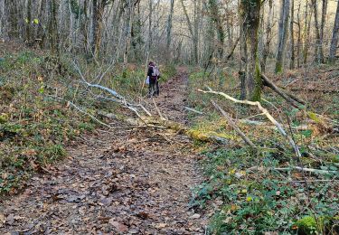
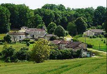
Partie de parcours probablement pas balisée. Randonné sympa au départ de Bussac qui vous mènera d'un coté à l'autre de La Donzelle.
Circuit en forme de huit en majorité en forêt sur des chemins et des petites routes peu fréquentées.
Merci Frodon & Cie
Plaatsbepaling
Land:
France
Regio :
Nieuw-Aquitanië
Departement/Provincie :
Dordogne
Gemeente :
Bussac
Locatie:
Unknown
Vertrek:(Dec)
Vertrek:(UTM)
312237 ; 5015984 (31T) N.
Opmerkingen
Wandeltochten in de omgeving
![Tocht Te voet Bussac - Boucle de Bussac - Photo](https://media.geolcdn.com/t/375/260/5fccc024-9483-4e9e-aafa-fb24ea2402de.jpeg&format=jpg&maxdim=2)
![Te voet Te voet](https://static1.geolcdn.com/sitytour/trail-icons/100.png)
Boucle de Bussac
Te voet
Gemakkelijk
Bussac,
Nieuw-Aquitanië,
Dordogne,
France
![](/images/other/stat-length.png)
3,7 km | 4,8 km-effort
1h 5min
![](https://static1.geolcdn.com/siteimages/upload/files/16400158638029165_repeat_loop_refresh_sync_direction_icon.png)
Ja
![Tocht Stappen Lisle - La boucle de Lisle - Photo](https://media.geolcdn.com/t/375/260/ext.jpg?maxdim=2&url=https%3A%2F%2Fservices.sitytrail.com%2FGeolivesWS%2FDownloadMedia.ashx%3FTrailID%3D329181%26Media%3Dfix__20140730111430.jpg)
![Stappen Stappen](https://static1.geolcdn.com/sitytour/trail-icons/101.png)
La boucle de Lisle
Stappen
Medium
Lisle,
Nieuw-Aquitanië,
Dordogne,
France
![](/images/other/stat-length.png)
9,9 km | 13,3 km-effort
3h 3min
![](https://static1.geolcdn.com/siteimages/upload/files/16400158638029165_repeat_loop_refresh_sync_direction_icon.png)
Ja
![Tocht Stappen La Chapelle-Gonaguet - La Chapelle Gonaguet 9 km - Photo](https://media.geolcdn.com/t/375/260/2419184c-9d78-41af-8bf7-802b3e84ff48.jpg&format=jpg&maxdim=2)
![Stappen Stappen](https://static1.geolcdn.com/sitytour/trail-icons/101.png)
La Chapelle Gonaguet 9 km
Stappen
Medium
La Chapelle-Gonaguet,
Nieuw-Aquitanië,
Dordogne,
France
![](/images/other/stat-length.png)
9 km | 10,7 km-effort
2h 26min
![](https://static1.geolcdn.com/siteimages/upload/files/16400158638029165_repeat_loop_refresh_sync_direction_icon.png)
Ja
![Tocht Noords wandelen Brantôme en Périgord - Puy de Fourches MN - Photo](https://media.geolcdn.com/t/375/260/b2e6b5db-70e9-4e82-9957-ec4047ed90be.jpg&format=jpg&maxdim=2)
![Noords wandelen Noords wandelen](https://static1.geolcdn.com/sitytour/trail-icons/102.png)
Puy de Fourches MN
Noords wandelen
Heel gemakkelijk
Brantôme en Périgord,
Nieuw-Aquitanië,
Dordogne,
France
![](/images/other/stat-length.png)
9,6 km | 12,6 km-effort
Onbekend
![](https://static1.geolcdn.com/siteimages/upload/files/16400158638029165_repeat_loop_refresh_sync_direction_icon.png)
Ja
![Tocht Stappen Brantôme en Périgord - Boucle de Puy de Fourches - Photo](https://media.geolcdn.com/t/375/260/9040ea6a-96c4-4be4-a516-67e0f8dd1119.jpg&format=jpg&maxdim=2)
![Stappen Stappen](https://static1.geolcdn.com/sitytour/trail-icons/101.png)
Boucle de Puy de Fourches
Stappen
Moeilijk
(3)
Brantôme en Périgord,
Nieuw-Aquitanië,
Dordogne,
France
![](/images/other/stat-length.png)
12,2 km | 15,1 km-effort
3h 25min
![](https://static1.geolcdn.com/siteimages/upload/files/16400158638029165_repeat_loop_refresh_sync_direction_icon.png)
Ja
![Tocht Stappen Lisle - Marche du mardi 4 février 2025 à Lisle - Photo](https://media.geolcdn.com/t/375/260/3ec1cf27-8540-44e0-a1c7-068547a846c5.jpg&format=jpg&maxdim=2)
![Stappen Stappen](https://static1.geolcdn.com/sitytour/trail-icons/101.png)
Marche du mardi 4 février 2025 à Lisle
Stappen
Gemakkelijk
Lisle,
Nieuw-Aquitanië,
Dordogne,
France
![](/images/other/stat-length.png)
10,1 km | 12,8 km-effort
2h 20min
![](https://static1.geolcdn.com/siteimages/upload/files/16400158638029165_repeat_loop_refresh_sync_direction_icon.png)
Ja
![Tocht Stappen Mensignac - randogps24-658 - Photo](https://media.geolcdn.com/t/375/260/ext.jpg?maxdim=2&url=https%3A%2F%2Fstatic1.geolcdn.com%2Fsiteimages%2Fupload%2Ffiles%2F1553511878bg_sport_marche.png)
![Stappen Stappen](https://static1.geolcdn.com/sitytour/trail-icons/101.png)
randogps24-658
Stappen
Moeilijk
Mensignac,
Nieuw-Aquitanië,
Dordogne,
France
![](/images/other/stat-length.png)
12,4 km | 15,7 km-effort
3h 33min
![](https://static1.geolcdn.com/siteimages/upload/files/16400158638029165_repeat_loop_refresh_sync_direction_icon.png)
Ja
![Tocht Noords wandelen La Chapelle-Gonaguet - SityTrail - La Chapelle-Gonaguet - Photo](https://media.geolcdn.com/t/375/260/ext.jpg?maxdim=2&url=https%3A%2F%2Fstatic1.geolcdn.com%2Fsiteimages%2Fupload%2Ffiles%2F1545311037marcheuse_200dpi.jpg)
![Noords wandelen Noords wandelen](https://static1.geolcdn.com/sitytour/trail-icons/102.png)
SityTrail - La Chapelle-Gonaguet
Noords wandelen
Gemakkelijk
La Chapelle-Gonaguet,
Nieuw-Aquitanië,
Dordogne,
France
![](/images/other/stat-length.png)
15,1 km | 18,5 km-effort
2h 40min
![](https://static1.geolcdn.com/siteimages/upload/files/16400158638029165_repeat_loop_refresh_sync_direction_icon.png)
Ja
![Tocht Stappen Biras - boucle biras - Photo](https://media.geolcdn.com/t/375/260/ext.jpg?maxdim=2&url=https%3A%2F%2Fstatic1.geolcdn.com%2Fsiteimages%2Fupload%2Ffiles%2F1553511878bg_sport_marche.png)
![Stappen Stappen](https://static1.geolcdn.com/sitytour/trail-icons/101.png)
boucle biras
Stappen
Heel gemakkelijk
(1)
Biras,
Nieuw-Aquitanië,
Dordogne,
France
![](/images/other/stat-length.png)
9,9 km | 13 km-effort
2h 52min
![](https://static1.geolcdn.com/siteimages/upload/files/16400158638029165_repeat_loop_refresh_sync_direction_icon.png)
Ja