![](/images/other/stat-length.png)
![Tocht Sneeuwschoenen Saint-Dalmas-le-Selvage - Pointe de Colombart - Photo](https://media.geolcdn.com/t/1900/400/a35428df-8d7e-4e62-a774-883e7f07eaa3.jpg&format=pjpeg&maxdim=2)
Pointe de Colombart
bozo1970
Gebruiker
![Lengte](/images/other/stat-length.png)
![Max. hoogte](https://static1.geolcdn.com/siteimages/upload/files/1508320355ic_sort_altitude_max_24dp.png)
![Positief hoogteverschil](https://static1.geolcdn.com/siteimages/upload/files/1508320355ic_sort_den_pos_24dp.png)
![Km-Effort](/images/other/stat-length.png)
![Min. hoogte](https://static1.geolcdn.com/siteimages/upload/files/1508320355ic_sort_altitude_min_24dp.png)
![Negatief hoogteverschil](https://static1.geolcdn.com/siteimages/upload/files/1508320355ic_sort_den_neg_24dp.png)
![Boucle](https://static1.geolcdn.com/siteimages/upload/files/16400158638029165_repeat_loop_refresh_sync_direction_icon.png)
![Sneeuwschoenen](https://static1.geolcdn.com/sitytour/trail-icons/504.png)
5h16
Moeilijkheid : Moeilijk
![Scan deze QR-code om de tocht te openen in de SityTrail-applicatie](https://capi.geolives.com/qq0zvz2zws4bq2lad0pu/sitytour/trails/3620258/qr.png?size=200)
Gratisgps-wandelapplicatie
Over ons
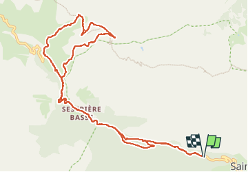
Tocht Sneeuwschoenen van 14 km beschikbaar op Provence-Alpes-Côte d'Azur, Alpes-Maritimes, Saint-Dalmas-le-Selvage. Deze tocht wordt voorgesteld door bozo1970.
Beschrijving
Départ sur la route du col de la Moutière
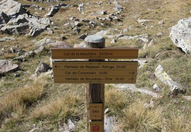
Refuge de Sestrière en 40’, 3km et D 270m
Montée par Sestrière haute
Col de Colombart en 3h, 7km400 et D 900m
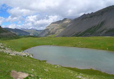
Pointe de Colombart en 3h26’, 7km800 et D 1000m
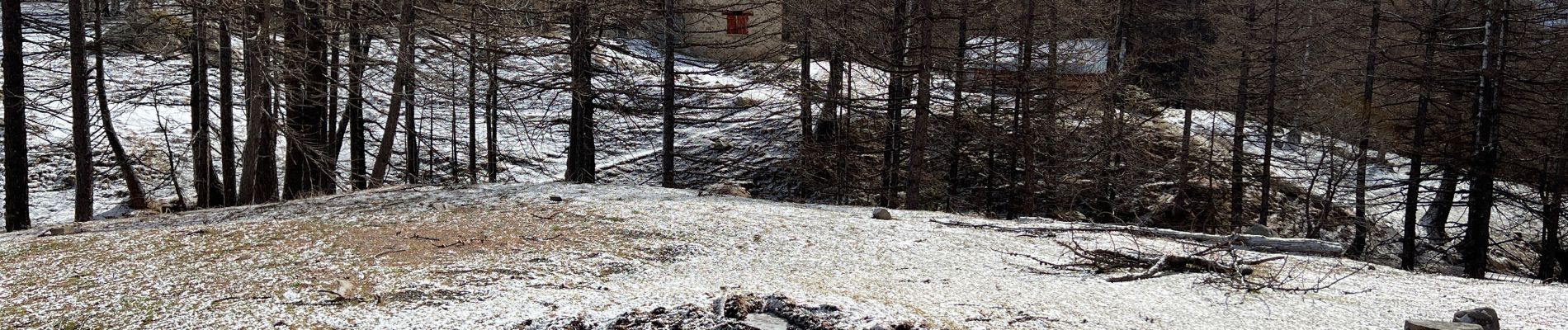
Le temps s’est couvert avec chutes de neige
A/R en 5h16’, 14 km350 et D 1000m
Plaatsbepaling
Opmerkingen
Wandeltochten in de omgeving
![Tocht Stappen Saint-Étienne-de-Tinée - Les Praz lacs de morgon pas de morgon col de fer - Photo](https://media.geolcdn.com/t/375/260/b305c453-9657-41de-ab22-a223a802df42.jpg&format=jpg&maxdim=2)
![Stappen Stappen](https://static1.geolcdn.com/sitytour/trail-icons/101.png)
Stappen
![](/images/other/stat-length.png)
![](https://static1.geolcdn.com/siteimages/upload/files/16400158638029165_repeat_loop_refresh_sync_direction_icon.png)
![Tocht Stappen Saint-Étienne-de-Tinée - Refuge de Vens par le Col du Fer - Photo](https://media.geolcdn.com/t/375/260/07f7f5f4-c466-4163-95bf-638647005431.jpg&format=jpg&maxdim=2)
![Stappen Stappen](https://static1.geolcdn.com/sitytour/trail-icons/101.png)
Stappen
![](/images/other/stat-length.png)
![](https://static1.geolcdn.com/siteimages/upload/files/16400158638029165_repeat_loop_refresh_sync_direction_icon.png)
![Tocht Stappen Saint-Étienne-de-Tinée - Reel Col du Fer lac refuge de Vens Cabane de Tortisse - Photo](https://media.geolcdn.com/t/375/260/43a881a4-8325-4e36-a280-d71b36c99c78.jpg&format=jpg&maxdim=2)
![Stappen Stappen](https://static1.geolcdn.com/sitytour/trail-icons/101.png)
Stappen
![](/images/other/stat-length.png)
![](https://static1.geolcdn.com/siteimages/upload/files/16400158638029165_repeat_loop_refresh_sync_direction_icon.png)
![Tocht Te voet Uvernet-Fours - Pointe de Colombart - Photo](https://media.geolcdn.com/t/375/260/5fc579df-5419-4dca-9bed-ffaaf89250e9.jpeg&format=jpg&maxdim=2)
![Te voet Te voet](https://static1.geolcdn.com/sitytour/trail-icons/100.png)
Te voet
![](/images/other/stat-length.png)
![](https://static1.geolcdn.com/siteimages/upload/files/16400158638029165_repeat_loop_refresh_sync_direction_icon.png)
![Tocht Te voet Saint-Dalmas-le-Selvage - Col de Gialorgues - Photo](https://media.geolcdn.com/t/375/260/00cae92e-e0d3-4da8-9c98-398ca7383338.jpeg&format=jpg&maxdim=2)
![Te voet Te voet](https://static1.geolcdn.com/sitytour/trail-icons/100.png)
Te voet
![](/images/other/stat-length.png)
![](https://static1.geolcdn.com/siteimages/upload/files/16400158638029165_repeat_loop_refresh_sync_direction_icon.png)
![Tocht Te voet Saint-Dalmas-le-Selvage - Crête de la Blanche - Photo](https://media.geolcdn.com/t/375/260/8fef9bcd-e2c1-4a5f-8511-8141c69ceadb.jpeg&format=jpg&maxdim=2)
![Te voet Te voet](https://static1.geolcdn.com/sitytour/trail-icons/100.png)
Te voet
![](/images/other/stat-length.png)
![](https://static1.geolcdn.com/siteimages/upload/files/16400158638029165_repeat_loop_refresh_sync_direction_icon.png)
![Tocht Te voet Saint-Étienne-de-Tinée - Chemin de l'Energie - Photo](https://media.geolcdn.com/t/375/260/45dc2ef9-a27b-439a-8012-c03ab217c2f9.jpeg&format=jpg&maxdim=2)
![Te voet Te voet](https://static1.geolcdn.com/sitytour/trail-icons/100.png)
Te voet
![](/images/other/stat-length.png)
![](https://static1.geolcdn.com/siteimages/upload/files/16400158638029165_repeat_loop_refresh_sync_direction_icon.png)
![Tocht Te voet Saint-Étienne-de-Tinée - Chemin de l'Energie - Etape 1 - Photo](https://media.geolcdn.com/t/375/260/0794a3d0-3fdc-40ed-a80f-245b620bf282.jpeg&format=jpg&maxdim=2)
![Te voet Te voet](https://static1.geolcdn.com/sitytour/trail-icons/100.png)
Te voet
![](/images/other/stat-length.png)
![](https://static1.geolcdn.com/siteimages/upload/files/16400158638029165_repeat_loop_refresh_sync_direction_icon.png)
![Tocht Stappen Saint-Dalmas-le-Selvage - crete de la blanche (sens inverse des aiguilles de la montre) - Photo](https://media.geolcdn.com/t/375/260/8277ee34-7f4f-4605-8ad8-3f70e64ea507.jpg&format=jpg&maxdim=2)
![Stappen Stappen](https://static1.geolcdn.com/sitytour/trail-icons/101.png)
Stappen
![](/images/other/stat-length.png)
![](https://static1.geolcdn.com/siteimages/upload/files/16400158638029165_repeat_loop_refresh_sync_direction_icon.png)