![](/images/other/stat-length.png)
![Tocht Stappen Hyères - La Capte Tour fondue - Photo](https://media.geolcdn.com/t/1900/400/5250a63d-1c5b-4d9a-9344-38f4a463abbf.jpg&format=pjpeg&maxdim=2)
La Capte Tour fondue
Marchopier
Gebruiker
![Lengte](/images/other/stat-length.png)
Lengte
14,6 km
![Max. hoogte](https://static1.geolcdn.com/siteimages/upload/files/1508320355ic_sort_altitude_max_24dp.png)
Max. hoogte
57 m
![Positief hoogteverschil](https://static1.geolcdn.com/siteimages/upload/files/1508320355ic_sort_den_pos_24dp.png)
Positief hoogteverschil
195 m
![Km-Effort](/images/other/stat-length.png)
Km-Effort
17,2 km
![Min. hoogte](https://static1.geolcdn.com/siteimages/upload/files/1508320355ic_sort_altitude_min_24dp.png)
Min. hoogte
-1 m
![Negatief hoogteverschil](https://static1.geolcdn.com/siteimages/upload/files/1508320355ic_sort_den_neg_24dp.png)
Negatief hoogteverschil
193 m
![Boucle](https://static1.geolcdn.com/siteimages/upload/files/16400158638029165_repeat_loop_refresh_sync_direction_icon.png)
Boucle
Ja
Datum van aanmaak :
2023-04-13 08:07:36.355
Laatste wijziging :
2023-04-13 16:10:03.164
![Stappen](https://static1.geolcdn.com/sitytour/trail-icons/101.png)
4h50
Moeilijkheid : Gemakkelijk
![Scan deze QR-code om de tocht te openen in de SityTrail-applicatie](https://capi.geolives.com/qq0zvz2zws4bq2lad0pu/sitytour/trails/3619895/qr.png?size=200)
Gratisgps-wandelapplicatie
Over ons
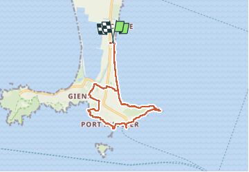
Tocht Stappen van 14,6 km beschikbaar op Provence-Alpes-Côte d'Azur, Var, Hyères. Deze tocht wordt voorgesteld door Marchopier.
Beschrijving
Boucle depuis La Capte, par la plage, puis le sentier du littoral de la presqu'île de Giens, la Tour Fondue, pizzeria Les Trois Îles, plage du Pradeau, Port Auguiers, Pointe Madame, Pointe de la Vignette, Giens, retour par la plage
Plaatsbepaling
Land:
France
Regio :
Provence-Alpes-Côte d'Azur
Departement/Provincie :
Var
Gemeente :
Hyères
Locatie:
Unknown
Vertrek:(Dec)
Vertrek:(UTM)
267782 ; 4771163 (32T) N.
Opmerkingen
Wandeltochten in de omgeving
![Tocht Stappen Hyères - SityTrail - presquile-de-giens-cote-est-france - Photo](https://media.geolcdn.com/t/375/260/111e178c-db2d-4519-839d-89c97a7ddc38.jpg&format=jpg&maxdim=2)
![Stappen Stappen](https://static1.geolcdn.com/sitytour/trail-icons/101.png)
SityTrail - presquile-de-giens-cote-est-france
Stappen
Gemakkelijk
(2)
Hyères,
Provence-Alpes-Côte d'Azur,
Var,
France
![](/images/other/stat-length.png)
11,9 km | 14,2 km-effort
4h 0min
![](https://static1.geolcdn.com/siteimages/upload/files/16400158638029165_repeat_loop_refresh_sync_direction_icon.png)
Ja
![Tocht Stappen Hyères - Presqu'ile de Gien_jeannot_22/04/2022 - Photo](https://media.geolcdn.com/t/375/260/8b67de46-9ea6-477a-b826-6ab82c4946f1.jpg&format=jpg&maxdim=2)
![Stappen Stappen](https://static1.geolcdn.com/sitytour/trail-icons/101.png)
Presqu'ile de Gien_jeannot_22/04/2022
Stappen
Medium
(1)
Hyères,
Provence-Alpes-Côte d'Azur,
Var,
France
![](/images/other/stat-length.png)
7,2 km | 10,5 km-effort
2h 22min
![](https://static1.geolcdn.com/siteimages/upload/files/16400158638029165_repeat_loop_refresh_sync_direction_icon.png)
Ja
![Tocht Stappen Hyères - Tour Fondue - La Madrague - Photo](https://media.geolcdn.com/t/375/260/ext.jpg?maxdim=2&url=https%3A%2F%2Fservices.sitytrail.com%2FGeolivesWS%2FDownloadMedia.ashx%3FTrailID%3D408792%26Media%3Dfix__20150414183437.jpg)
![Stappen Stappen](https://static1.geolcdn.com/sitytour/trail-icons/101.png)
Tour Fondue - La Madrague
Stappen
Heel gemakkelijk
(1)
Hyères,
Provence-Alpes-Côte d'Azur,
Var,
France
![](/images/other/stat-length.png)
7,7 km | 10,5 km-effort
1h 51min
![](https://static1.geolcdn.com/siteimages/upload/files/16400158638029165_repeat_loop_refresh_sync_direction_icon.png)
Neen
![Tocht Stappen Hyères - pointe ouest - Photo](https://media.geolcdn.com/t/375/260/ext.jpg?maxdim=2&url=https%3A%2F%2Fservices.sitytrail.com%2FGeolivesWS%2FDownloadMedia.ashx%3FTrailID%3D408941%26Media%3Dfix__20150417131644.jpg)
![Stappen Stappen](https://static1.geolcdn.com/sitytour/trail-icons/101.png)
pointe ouest
Stappen
Heel gemakkelijk
(1)
Hyères,
Provence-Alpes-Côte d'Azur,
Var,
France
![](/images/other/stat-length.png)
8,3 km | 12 km-effort
3h 31min
![](https://static1.geolcdn.com/siteimages/upload/files/16400158638029165_repeat_loop_refresh_sync_direction_icon.png)
Ja
![Tocht Stappen Hyères - giens - Photo](https://media.geolcdn.com/t/375/260/ext.jpg?maxdim=2&url=https%3A%2F%2Fservices.sitytrail.com%2FGeolivesWS%2FDownloadMedia.ashx%3FTrailID%3D215644%26Media%3Dfix__20130821153200.jpg)
![Stappen Stappen](https://static1.geolcdn.com/sitytour/trail-icons/101.png)
giens
Stappen
Gemakkelijk
(2)
Hyères,
Provence-Alpes-Côte d'Azur,
Var,
France
![](/images/other/stat-length.png)
7 km | 10,5 km-effort
2h 31min
![](https://static1.geolcdn.com/siteimages/upload/files/16400158638029165_repeat_loop_refresh_sync_direction_icon.png)
Ja
![Tocht Stappen Hyères - Presqu'île de Grenoble Est 2/10/21 - Photo](https://media.geolcdn.com/t/375/260/ext.jpg?maxdim=2&url=https%3A%2F%2Fstatic1.geolcdn.com%2Fsiteimages%2Fupload%2Ffiles%2F1553511878bg_sport_marche.png)
![Stappen Stappen](https://static1.geolcdn.com/sitytour/trail-icons/101.png)
Presqu'île de Grenoble Est 2/10/21
Stappen
Gemakkelijk
(1)
Hyères,
Provence-Alpes-Côte d'Azur,
Var,
France
![](/images/other/stat-length.png)
8,6 km | 10,5 km-effort
3h 0min
![](https://static1.geolcdn.com/siteimages/upload/files/16400158638029165_repeat_loop_refresh_sync_direction_icon.png)
Ja
![Tocht Wegfiets Hyères - Hyères J1 P13 - Photo](https://media.geolcdn.com/t/375/260/0ca1c939-16f5-433a-9547-e226cdb8bcbb.jpg&format=jpg&maxdim=2)
![Wegfiets Wegfiets](https://static1.geolcdn.com/sitytour/trail-icons/201.png)
Hyères J1 P13
Wegfiets
Medium
Hyères,
Provence-Alpes-Côte d'Azur,
Var,
France
![](/images/other/stat-length.png)
88 km | 101 km-effort
5h 0min
![](https://static1.geolcdn.com/siteimages/upload/files/16400158638029165_repeat_loop_refresh_sync_direction_icon.png)
Ja
![Tocht Stappen Hyères - SityTrail - VLT 2017 Giens Ouest - Photo](https://media.geolcdn.com/t/375/260/bd7bab5a-2900-4f1f-a633-f134e0b35fdd.jpg&format=jpg&maxdim=2)
![Stappen Stappen](https://static1.geolcdn.com/sitytour/trail-icons/101.png)
SityTrail - VLT 2017 Giens Ouest
Stappen
Medium
Hyères,
Provence-Alpes-Côte d'Azur,
Var,
France
![](/images/other/stat-length.png)
12,4 km | 17,6 km-effort
5h 0min
![](https://static1.geolcdn.com/siteimages/upload/files/16400158638029165_repeat_loop_refresh_sync_direction_icon.png)
Ja