![](/images/other/stat-length.png)
![Tocht Elektrische fiets Teillet-Argenty - les eoliennes - Photo](https://media.geolcdn.com/t/1900/400/ext.pjpeg?maxdim=2&url=https%3A%2F%2Fstatic1.geolcdn.com%2Fsiteimages%2Fupload%2Ffiles%2F1524743154velo.jpg)
les eoliennes
Bertrand Michalon
Gebruiker
![Lengte](/images/other/stat-length.png)
Lengte
24 km
![Max. hoogte](https://static1.geolcdn.com/siteimages/upload/files/1508320355ic_sort_altitude_max_24dp.png)
Max. hoogte
495 m
![Positief hoogteverschil](https://static1.geolcdn.com/siteimages/upload/files/1508320355ic_sort_den_pos_24dp.png)
Positief hoogteverschil
277 m
![Km-Effort](/images/other/stat-length.png)
Km-Effort
27 km
![Min. hoogte](https://static1.geolcdn.com/siteimages/upload/files/1508320355ic_sort_altitude_min_24dp.png)
Min. hoogte
351 m
![Negatief hoogteverschil](https://static1.geolcdn.com/siteimages/upload/files/1508320355ic_sort_den_neg_24dp.png)
Negatief hoogteverschil
284 m
![Boucle](https://static1.geolcdn.com/siteimages/upload/files/16400158638029165_repeat_loop_refresh_sync_direction_icon.png)
Boucle
Ja
Datum van aanmaak :
2023-04-09 11:53:16.605
Laatste wijziging :
2023-04-09 15:03:15.163
![Elektrische fiets](https://static1.geolcdn.com/sitytour/trail-icons/205.png)
3h08
Moeilijkheid : Heel gemakkelijk
![Scan deze QR-code om de tocht te openen in de SityTrail-applicatie](https://capi.geolives.com/qq0zvz2zws4bq2lad0pu/sitytour/trails/3615012/qr.png?size=200)
Gratisgps-wandelapplicatie
Over ons
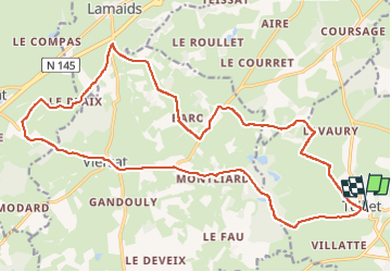
Tocht Elektrische fiets van 24 km beschikbaar op Auvergne-Rhône-Alpes, Allier, Teillet-Argenty. Deze tocht wordt voorgesteld door Bertrand Michalon .
Beschrijving
Teillet direction L'amande, parc des éoliennes puis direction viens-tu et retour par les etangs
Plaatsbepaling
Land:
France
Regio :
Auvergne-Rhône-Alpes
Departement/Provincie :
Allier
Gemeente :
Teillet-Argenty
Locatie:
Unknown
Vertrek:(Dec)
Vertrek:(UTM)
462353 ; 5122994 (31T) N.
Opmerkingen
Wandeltochten in de omgeving
![Tocht Stappen Lignerolles - Gorges du Cher - Photo](https://media.geolcdn.com/t/375/260/1d86fa91-e4e1-4d18-ae3d-b4e057ae83c7.jpg&format=jpg&maxdim=2)
![Stappen Stappen](https://static1.geolcdn.com/sitytour/trail-icons/101.png)
Gorges du Cher
Stappen
Moeilijk
Lignerolles,
Auvergne-Rhône-Alpes,
Allier,
France
![](/images/other/stat-length.png)
9,4 km | 11,8 km-effort
3h 15min
![](https://static1.geolcdn.com/siteimages/upload/files/16400158638029165_repeat_loop_refresh_sync_direction_icon.png)
Ja
![Tocht Te voet Mazirat - Les Dames de Charly - Photo](https://media.geolcdn.com/t/375/260/ext.jpg?maxdim=2&url=https%3A%2F%2Fstatic1.geolcdn.com%2Fsiteimages%2Fupload%2Ffiles%2F1545311037marcheuse_200dpi.jpg)
![Te voet Te voet](https://static1.geolcdn.com/sitytour/trail-icons/100.png)
Les Dames de Charly
Te voet
Gemakkelijk
Mazirat,
Auvergne-Rhône-Alpes,
Allier,
France
![](/images/other/stat-length.png)
7,3 km | 9 km-effort
2h 2min
![](https://static1.geolcdn.com/siteimages/upload/files/16400158638029165_repeat_loop_refresh_sync_direction_icon.png)
Ja
![Tocht Mountainbike Lignerolles - Les gorges du cher au fil de l eau - Photo](https://media.geolcdn.com/t/375/260/ext.jpg?maxdim=2&url=https%3A%2F%2Fstatic1.geolcdn.com%2Fsiteimages%2Fupload%2Ffiles%2F1524743154velo.jpg)
![Mountainbike Mountainbike](https://static1.geolcdn.com/sitytour/trail-icons/202.png)
Les gorges du cher au fil de l eau
Mountainbike
Medium
Lignerolles,
Auvergne-Rhône-Alpes,
Allier,
France
![](/images/other/stat-length.png)
4,8 km | 6,8 km-effort
45min
![](https://static1.geolcdn.com/siteimages/upload/files/16400158638029165_repeat_loop_refresh_sync_direction_icon.png)
Ja
![Tocht Stappen Teillet-Argenty - La Celtique - Photo](https://media.geolcdn.com/t/375/260/ext.jpg?maxdim=2&url=https%3A%2F%2Fstatic1.geolcdn.com%2Fsiteimages%2Fupload%2Ffiles%2F1553511878bg_sport_marche.png)
![Stappen Stappen](https://static1.geolcdn.com/sitytour/trail-icons/101.png)
La Celtique
Stappen
Medium
Teillet-Argenty,
Auvergne-Rhône-Alpes,
Allier,
France
![](/images/other/stat-length.png)
12,7 km | 15 km-effort
2h 30min
![](https://static1.geolcdn.com/siteimages/upload/files/16400158638029165_repeat_loop_refresh_sync_direction_icon.png)
Neen
![Tocht Stappen Évaux-les-Bains - Le confluent du Cher et de la Tardes à proximité d'Évaux-les-Bains - Photo](https://media.geolcdn.com/t/375/260/ext.jpg?maxdim=2&url=https%3A%2F%2Fstatic1.geolcdn.com%2Fsiteimages%2Fupload%2Ffiles%2F1553511878bg_sport_marche.png)
![Stappen Stappen](https://static1.geolcdn.com/sitytour/trail-icons/101.png)
Le confluent du Cher et de la Tardes à proximité d'Évaux-les-Bains
Stappen
Gemakkelijk
Évaux-les-Bains,
Nieuw-Aquitanië,
Creuse,
France
![](/images/other/stat-length.png)
4,5 km | 6,3 km-effort
1h 26min
![](https://static1.geolcdn.com/siteimages/upload/files/16400158638029165_repeat_loop_refresh_sync_direction_icon.png)
Ja
![Tocht Stappen Teillet-Argenty - ballade à Teillet - Photo](https://media.geolcdn.com/t/375/260/ext.jpg?maxdim=2&url=https%3A%2F%2Fstatic1.geolcdn.com%2Fsiteimages%2Fupload%2Ffiles%2F1553511878bg_sport_marche.png)
![Stappen Stappen](https://static1.geolcdn.com/sitytour/trail-icons/101.png)
ballade à Teillet
Stappen
Heel gemakkelijk
Teillet-Argenty,
Auvergne-Rhône-Alpes,
Allier,
France
![](/images/other/stat-length.png)
6,9 km | 8,2 km-effort
1h 43min
![](https://static1.geolcdn.com/siteimages/upload/files/16400158638029165_repeat_loop_refresh_sync_direction_icon.png)
Ja
![Tocht Elektrische fiets Teillet-Argenty - Vtt fev23 - Photo](https://media.geolcdn.com/t/375/260/ext.jpg?maxdim=2&url=https%3A%2F%2Fstatic1.geolcdn.com%2Fsiteimages%2Fupload%2Ffiles%2F1524743154velo.jpg)
![Elektrische fiets Elektrische fiets](https://static1.geolcdn.com/sitytour/trail-icons/205.png)
Vtt fev23
Elektrische fiets
Medium
Teillet-Argenty,
Auvergne-Rhône-Alpes,
Allier,
France
![](/images/other/stat-length.png)
23 km | 28 km-effort
2h 23min
![](https://static1.geolcdn.com/siteimages/upload/files/16400158638029165_repeat_loop_refresh_sync_direction_icon.png)
Ja
![Tocht Stappen Teillet-Argenty - autour de teillet - Photo](https://media.geolcdn.com/t/375/260/ext.jpg?maxdim=2&url=https%3A%2F%2Fstatic1.geolcdn.com%2Fsiteimages%2Fupload%2Ffiles%2F1553511878bg_sport_marche.png)
![Stappen Stappen](https://static1.geolcdn.com/sitytour/trail-icons/101.png)
autour de teillet
Stappen
Heel gemakkelijk
(2)
Teillet-Argenty,
Auvergne-Rhône-Alpes,
Allier,
France
![](/images/other/stat-length.png)
9,8 km | 11,8 km-effort
2h 24min
![](https://static1.geolcdn.com/siteimages/upload/files/16400158638029165_repeat_loop_refresh_sync_direction_icon.png)
Ja
![Tocht Stappen Budelière - budeliere - Photo](https://media.geolcdn.com/t/375/260/ext.jpg?maxdim=2&url=https%3A%2F%2Fstatic1.geolcdn.com%2Fsiteimages%2Fupload%2Ffiles%2F1553511878bg_sport_marche.png)
![Stappen Stappen](https://static1.geolcdn.com/sitytour/trail-icons/101.png)
budeliere
Stappen
Medium
Budelière,
Nieuw-Aquitanië,
Creuse,
France
![](/images/other/stat-length.png)
8,2 km | 9,3 km-effort
2h 3min
![](https://static1.geolcdn.com/siteimages/upload/files/16400158638029165_repeat_loop_refresh_sync_direction_icon.png)
Ja