Tocht Wegfiets Manduel - VELO 2023.04.08 - Le Pont du Gard, Beaucaire  - Photo

VELO 2023.04.08 - Le Pont du Gard, Beaucaire

 rando30129
rando30129

Gebruiker

© OpenStreetMap contributors
Lengte
Lengte
86 km
Max. hoogte
Max. hoogte
74 m
Positief hoogteverschil
608 m
Km-Effort
Km-Effort  
94 km
Min. hoogte
Min. hoogte
-6 m
Negatief hoogteverschil
609 m
Boucle
Boucle
Ja
Datum van aanmaak :
2023-04-08 09:29:16.0
Laatste wijziging :
2023-04-12 17:21:35.36

(0 Bericht)

Wegfiets
Wegfiets
8h23
Moeilijkheid : Zeer moeilijk

Scan deze QR-code om de tocht te openen in de SityTrail-applicatie

Gratisgps-wandelapplicatie

Logo SityTrail SityTrail

IGN / Geografische instituten

SityTrail uit de App Store downloaden SityTrail uit Google Play downloaden

Logo SityTrail SityTrail World

De wereld gaat voor u open

SityTrail uit de App Store downloaden SityTrail uit Google Play downloaden SityTrail op Huawei AppGallery downloaden

Over ons

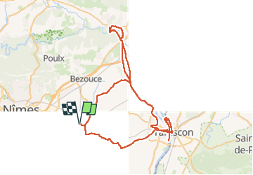
Tocht Wegfiets van 86 km beschikbaar op Occitanië, Gard, Manduel. Deze tocht wordt voorgesteld door rando30129.

Beschrijving

Le Pont du Gard, Beaucaire, Tarascon, l’île, Mourgues du Grès, Campuget

Hoogteprofiel

Plaatsbepaling

Land:
France
Regio :
Occitanië
Departement/Provincie :
Gard
Gemeente :
Manduel
Locatie:
Unknown
Vertrek:(Dec)
Vertrek:(UTM)
618725 ; 4852569 (31T) N.

Wandeltochten in de omgeving

Tocht Te voet Jonquières-Saint-Vincent - Randonnée la Voie Domitia - Photo
Te voet
PRO

Te voet

Gemakkelijk
Jonquières-Saint-Vincent, Occitanië, Gard, France
9,5 km | 10 km-effort
2h 16min
Neen
Tocht Te voet Redessan - Balade autour de Redessan - Photo
Te voet
PRO

Te voet

Gemakkelijk
Redessan, Occitanië, Gard, France
6,3 km | 6,6 km-effort
1h 29min
Ja
Tocht Te voet Rodilhan - Autour de Rodilhan, circuit 2 - Photo
Te voet
PatCoria

Te voet

Heel gemakkelijk
Rodilhan, Occitanië, Gard, France
7,1 km | 7,6 km-effort
1h 45min
Ja
Tocht Te voet Rodilhan - Tour de Rodilhan - Photo
Te voet
PatCoria

Te voet

Heel gemakkelijk
Rodilhan, Occitanië, Gard, France
6 km | 6,5 km-effort
1h 40min
Ja
Tocht Stappen Marguerittes - Tttttttyyyyuii - Photo
Stappen
rando30129

Stappen

Medium
Marguerittes, Occitanië, Gard, France
7,9 km | 8,4 km-effort
18h 1min
Neen
Tocht Stappen Nîmes - les vestiges de l'aqueduc Marguerite  - Photo
Stappen
Giloudu30

Stappen

Medium
Nîmes, Occitanië, Gard, France
6,2 km | 7,7 km-effort
1h 33min
Ja
Tocht Stappen Rodilhan - rodilhan bouillargues - Photo
Stappen
jeanjean300

Stappen

Heel gemakkelijk
Rodilhan, Occitanië, Gard, France
9,2 km | 9,8 km-effort
2h 13min
Ja
Tocht Stappen Bouillargues - Nîmes roses par chemin des manades - Photo
Stappen
Michele Chabert

Stappen

Heel gemakkelijk
Bouillargues, Occitanië, Gard, France
3,1 km | 3,3 km-effort
45min
Ja
Tocht Stappen Marguerittes - 30 - MARGUERITTES -TOUR DU MAS DE BEAULIEU - Photo
Stappen
dansmabulle

Stappen

Heel gemakkelijk
Marguerittes, Occitanië, Gard, France
2,6 km | 2,7 km-effort
39min
Ja


Sluiten
Mijn abonnementen