![](/images/other/stat-length.png)
![Tocht Lagnes - 2023-04-03_10h48m14_newtrack - Photo](https://media.geolcdn.com/t/1900/400/ext.pjpeg?maxdim=2&url=https%3A%2F%2Fsecurestorage.geolives.com%2Fsitytour%2Ftrail-bg%2Fdefault.jpg)
2023-04-03_10h48m14_newtrack
mapfaillettaz
Gebruiker
![Lengte](/images/other/stat-length.png)
![Max. hoogte](https://static1.geolcdn.com/siteimages/upload/files/1508320355ic_sort_altitude_max_24dp.png)
![Positief hoogteverschil](https://static1.geolcdn.com/siteimages/upload/files/1508320355ic_sort_den_pos_24dp.png)
![Km-Effort](/images/other/stat-length.png)
![Min. hoogte](https://static1.geolcdn.com/siteimages/upload/files/1508320355ic_sort_altitude_min_24dp.png)
![Negatief hoogteverschil](https://static1.geolcdn.com/siteimages/upload/files/1508320355ic_sort_den_neg_24dp.png)
![Boucle](https://static1.geolcdn.com/siteimages/upload/files/16400158638029165_repeat_loop_refresh_sync_direction_icon.png)
![Scan deze QR-code om de tocht te openen in de SityTrail-applicatie](https://capi.geolives.com/qq0zvz2zws4bq2lad0pu/sitytour/trails/3607286/qr.png?size=200)
Gratisgps-wandelapplicatie
Over ons
Tocht van 15,8 km beschikbaar op Provence-Alpes-Côte d'Azur, Vaucluse, Lagnes. Deze tocht wordt voorgesteld door mapfaillettaz.
Beschrijving
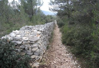
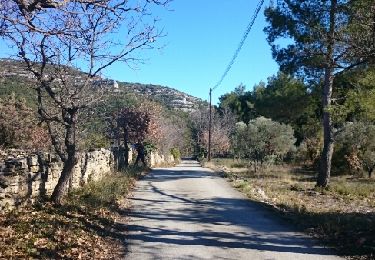
Petit mais très beau tour, très typique des Monts-de-Vaucluse, avec ses sentiers sinueux, caillouteux et ludiques, un patrimoine bâti en pierre sèche omniprésent, puis une garrigue, une forêt de pins et de cèdres très odorantes... En prime, la traversée de deux très beaux villages Lagnes et Cabrières d'Avignon, au patrimoine bâti exceptionnel, puis les beaux vestiges du Mur de la Peste, barrière sanitaire contre la pandémie de peste provençale de 1721 à 1723.
# difficulté : BLEU (facile).
# départ : devant la mairie de Lagnes.
ATTENTION : bien maîtriser sa vitesse en descente ; vous n'êtes pas seul sur ces sentiers !
Plaatsbepaling
Opmerkingen
Wandeltochten in de omgeving
![Tocht Stappen Fontaine-de-Vaucluse - Fontaine de Vaucluse par l'aven de Valescure, les crêtes et le chateau - Photo](https://media.geolcdn.com/t/375/260/151070e1-18c8-4062-b1e4-7770840cd66e.jpg&format=jpg&maxdim=2)
![Stappen Stappen](https://static1.geolcdn.com/sitytour/trail-icons/101.png)
Stappen
![](/images/other/stat-length.png)
![](https://static1.geolcdn.com/siteimages/upload/files/16400158638029165_repeat_loop_refresh_sync_direction_icon.png)
![Tocht Stappen Lagnes - Lagnes Tête du Soldat Mur de la peste Esperacons - Photo](https://media.geolcdn.com/t/375/260/a1cbca5d-1ba7-4e0a-a45d-e364265b058f.jpg&format=jpg&maxdim=2)
![Stappen Stappen](https://static1.geolcdn.com/sitytour/trail-icons/101.png)
Stappen
![](/images/other/stat-length.png)
![](https://static1.geolcdn.com/siteimages/upload/files/16400158638029165_repeat_loop_refresh_sync_direction_icon.png)
![Tocht Stappen Lagnes - Lagnes - La Tête du Soldat - Mur de la Peste - Photo](https://media.geolcdn.com/t/375/260/ext.jpg?maxdim=2&url=https%3A%2F%2Fservices.sitytrail.com%2FGeolivesWS%2FDownloadMedia.ashx%3FTrailID%3D103456%26Media%3D5577_2.jpg)
![Stappen Stappen](https://static1.geolcdn.com/sitytour/trail-icons/101.png)
Stappen
![](/images/other/stat-length.png)
![](https://static1.geolcdn.com/siteimages/upload/files/16400158638029165_repeat_loop_refresh_sync_direction_icon.png)
![Tocht Stappen Fontaine-de-Vaucluse - Ballade le long du canal de Carpentras - Photo](https://media.geolcdn.com/t/375/260/3ef0eb2a-23ef-4d53-a230-1b96fa5cca74.jpg&format=jpg&maxdim=2)
![Stappen Stappen](https://static1.geolcdn.com/sitytour/trail-icons/101.png)
Stappen
![](/images/other/stat-length.png)
![](https://static1.geolcdn.com/siteimages/upload/files/16400158638029165_repeat_loop_refresh_sync_direction_icon.png)
![Tocht Stappen Lagnes - SityTrail - 2022-04-07_18h36m42_lagnes-et-le-mur-de-la-peste - Photo](https://media.geolcdn.com/t/375/260/3379eca8-2f59-4c0c-b19b-ccc327c00164.jpg&format=jpg&maxdim=2)
![Stappen Stappen](https://static1.geolcdn.com/sitytour/trail-icons/101.png)
Stappen
![](/images/other/stat-length.png)
![](https://static1.geolcdn.com/siteimages/upload/files/16400158638029165_repeat_loop_refresh_sync_direction_icon.png)
![Tocht Hybride fiets Lagnes - La coutelière <> L’Isle Sur La Sorgue - Photo](https://media.geolcdn.com/t/375/260/ext.jpg?maxdim=2&url=https%3A%2F%2Fstatic1.geolcdn.com%2Fsiteimages%2Fupload%2Ffiles%2F1524743154velo.jpg)
![Hybride fiets Hybride fiets](https://static1.geolcdn.com/sitytour/trail-icons/203.png)
Hybride fiets
![](/images/other/stat-length.png)
![](https://static1.geolcdn.com/siteimages/upload/files/16400158638029165_repeat_loop_refresh_sync_direction_icon.png)
![Stappen Stappen](https://static1.geolcdn.com/sitytour/trail-icons/101.png)
Stappen
![](/images/other/stat-length.png)
![](https://static1.geolcdn.com/siteimages/upload/files/16400158638029165_repeat_loop_refresh_sync_direction_icon.png)
![Tocht Stappen Fontaine-de-Vaucluse - di 22022015 lagnes bondelon - Photo](https://media.geolcdn.com/t/375/260/ext.jpg?maxdim=2&url=https%3A%2F%2Fservices.sitytrail.com%2FGeolivesWS%2FDownloadMedia.ashx%3FTrailID%3D388879%26Media%3Dfix__20150222143029.jpg)
![Stappen Stappen](https://static1.geolcdn.com/sitytour/trail-icons/101.png)
Stappen
![](/images/other/stat-length.png)
![](https://static1.geolcdn.com/siteimages/upload/files/16400158638029165_repeat_loop_refresh_sync_direction_icon.png)
![Tocht Stappen Fontaine-de-Vaucluse - Fontaine du Vaucluse - Photo](https://media.geolcdn.com/t/375/260/ext.jpg?maxdim=2&url=https%3A%2F%2Fstatic1.geolcdn.com%2Fsiteimages%2Fupload%2Ffiles%2F1553511878bg_sport_marche.png)
![Stappen Stappen](https://static1.geolcdn.com/sitytour/trail-icons/101.png)
Stappen
![](/images/other/stat-length.png)
![](https://static1.geolcdn.com/siteimages/upload/files/16400158638029165_repeat_loop_refresh_sync_direction_icon.png)