![](/images/other/stat-length.png)
![Tocht Stappen Jalhay - Solwaster - Photo](https://media.geolcdn.com/t/1900/400/ext.pjpeg?maxdim=2&url=https%3A%2F%2Fstatic1.geolcdn.com%2Fsiteimages%2Fupload%2Ffiles%2F1553511878bg_sport_marche.png)
Solwaster
micheldutilleul
Gebruiker
![Lengte](/images/other/stat-length.png)
Lengte
24 km
![Max. hoogte](https://static1.geolcdn.com/siteimages/upload/files/1508320355ic_sort_altitude_max_24dp.png)
Max. hoogte
610 m
![Positief hoogteverschil](https://static1.geolcdn.com/siteimages/upload/files/1508320355ic_sort_den_pos_24dp.png)
Positief hoogteverschil
554 m
![Km-Effort](/images/other/stat-length.png)
Km-Effort
31 km
![Min. hoogte](https://static1.geolcdn.com/siteimages/upload/files/1508320355ic_sort_altitude_min_24dp.png)
Min. hoogte
222 m
![Negatief hoogteverschil](https://static1.geolcdn.com/siteimages/upload/files/1508320355ic_sort_den_neg_24dp.png)
Negatief hoogteverschil
590 m
![Boucle](https://static1.geolcdn.com/siteimages/upload/files/16400158638029165_repeat_loop_refresh_sync_direction_icon.png)
Boucle
Neen
Datum van aanmaak :
2023-04-02 09:22:38.981
Laatste wijziging :
2023-04-02 14:00:18.754
![Stappen](https://static1.geolcdn.com/sitytour/trail-icons/101.png)
4h30
Moeilijkheid : Medium
![Scan deze QR-code om de tocht te openen in de SityTrail-applicatie](https://capi.geolives.com/qq0zvz2zws4bq2lad0pu/sitytour/trails/3606501/qr.png?size=200)
Gratisgps-wandelapplicatie
Over ons
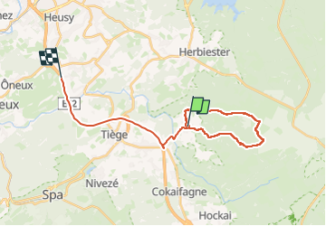
Tocht Stappen van 24 km beschikbaar op Wallonië, Luik, Jalhay. Deze tocht wordt voorgesteld door micheldutilleul.
Beschrijving
Magnifique randonnée dans les bois, le long de la Sawe et la Statte. De nombreuses traversées via des ponts.
Randonnée pour des habitués et pas avec de petits enfants.
De nombreux passages délicats le long de l eau.
À faire avec de bonnes chaussures de marche.
Plaatsbepaling
Land:
Belgium
Regio :
Wallonië
Departement/Provincie :
Luik
Gemeente :
Jalhay
Locatie:
Unknown
Vertrek:(Dec)
Vertrek:(UTM)
710215 ; 5601214 (31U) N.
Opmerkingen
Wandeltochten in de omgeving
![Tocht Stappen Jalhay - RB-LG-06 Raccourci 2 - Photo](https://media.geolcdn.com/t/375/260/ext.jpg?maxdim=2&url=https%3A%2F%2Fservices.sitytrail.com%2FGeolivesWS%2FDownloadMedia.ashx%3FTrailID%3D209412%26Media%3Dcbaa668b-becb-4b36-acb0-64f56a1c97b3.jpg)
![Stappen Stappen](https://static1.geolcdn.com/sitytour/trail-icons/101.png)
RB-LG-06 Raccourci 2
Stappen
Moeilijk
(6)
Jalhay,
Wallonië,
Luik,
Belgium
![](/images/other/stat-length.png)
10,1 km | 13,3 km-effort
3h 1min
![](https://static1.geolcdn.com/siteimages/upload/files/16400158638029165_repeat_loop_refresh_sync_direction_icon.png)
Ja
![Tocht Stappen Jalhay - RB-LG-06 - Au pied du plateau des Hautes Fagnes La balade des ruisseaux - Photo](https://media.geolcdn.com/t/375/260/ext.jpg?maxdim=2&url=https%3A%2F%2Fservices.sitytrail.com%2FGeolivesWS%2FDownloadMedia.ashx%3FTrailID%3D179564%26Media%3Dcbaa668b-becb-4b36-acb0-64f56a1c97b3.jpg)
![Stappen Stappen](https://static1.geolcdn.com/sitytour/trail-icons/101.png)
RB-LG-06 - Au pied du plateau des Hautes Fagnes La balade des ruisseaux
Stappen
Zeer moeilijk
(7)
Jalhay,
Wallonië,
Luik,
Belgium
![](/images/other/stat-length.png)
26 km | 35 km-effort
8h 0min
![](https://static1.geolcdn.com/siteimages/upload/files/16400158638029165_repeat_loop_refresh_sync_direction_icon.png)
Ja
![Tocht Stappen Jalhay - Solwaster. Natura 2000, des sites qui valent le détour. Lg8 - Photo](https://media.geolcdn.com/t/375/260/ext.jpg?maxdim=2&url=https%3A%2F%2Fservices.sitytrail.com%2FGeolivesWS%2FDownloadMedia.ashx%3FTrailID%3D185776%26Media%3D07ec0791-d24b-4377-8f42-10c75b77cede.jpg)
![Stappen Stappen](https://static1.geolcdn.com/sitytour/trail-icons/101.png)
Solwaster. Natura 2000, des sites qui valent le détour. Lg8
Stappen
Moeilijk
(9)
Jalhay,
Wallonië,
Luik,
Belgium
![](/images/other/stat-length.png)
6,8 km | 9,1 km-effort
1h 58min
![](https://static1.geolcdn.com/siteimages/upload/files/16400158638029165_repeat_loop_refresh_sync_direction_icon.png)
Ja
![Tocht Stappen Jalhay - Pont de Belleheid à Spa par le GRP 573 - Photo](https://media.geolcdn.com/t/375/260/0d2f83e8-ec88-4180-940e-6c42b7bb9bcf.jpg&format=jpg&maxdim=2)
![Stappen Stappen](https://static1.geolcdn.com/sitytour/trail-icons/101.png)
Pont de Belleheid à Spa par le GRP 573
Stappen
Medium
(1)
Jalhay,
Wallonië,
Luik,
Belgium
![](/images/other/stat-length.png)
14 km | 17,8 km-effort
4h 2min
![](https://static1.geolcdn.com/siteimages/upload/files/16400158638029165_repeat_loop_refresh_sync_direction_icon.png)
Neen
![Stappen Stappen](https://static1.geolcdn.com/sitytour/trail-icons/101.png)
20220901 - Jehanster 5.3 Km
Stappen
Medium
(1)
Theux,
Wallonië,
Luik,
Belgium
![](/images/other/stat-length.png)
5,3 km | 6,8 km-effort
1h 32min
![](https://static1.geolcdn.com/siteimages/upload/files/16400158638029165_repeat_loop_refresh_sync_direction_icon.png)
Ja
![Stappen Stappen](https://static1.geolcdn.com/sitytour/trail-icons/101.png)
20211213 - Hockay 5.4 Km
Stappen
Medium
(3)
Stavelot,
Wallonië,
Luik,
Belgium
![](/images/other/stat-length.png)
5,1 km | 6,6 km-effort
1h 34min
![](https://static1.geolcdn.com/siteimages/upload/files/16400158638029165_repeat_loop_refresh_sync_direction_icon.png)
Ja
![Tocht Stappen Jalhay - 2021-11-16_21h27m43_Cirkwi-Balade_à_Jalhay-Royompré_-_47 - Photo](https://media.geolcdn.com/t/375/260/94c262e0-20e7-4ae2-8b45-01b4c31da73b.jpg&format=jpg&maxdim=2)
![Stappen Stappen](https://static1.geolcdn.com/sitytour/trail-icons/101.png)
2021-11-16_21h27m43_Cirkwi-Balade_à_Jalhay-Royompré_-_47
Stappen
Gemakkelijk
(2)
Jalhay,
Wallonië,
Luik,
Belgium
![](/images/other/stat-length.png)
11 km | 13,9 km-effort
3h 9min
![](https://static1.geolcdn.com/siteimages/upload/files/16400158638029165_repeat_loop_refresh_sync_direction_icon.png)
Ja
![Tocht Stappen Jalhay - 2021-11-16_21h12m11_Cirkwi-Solwaster_Sawe_-_balade_56_B (1) - Photo](https://media.geolcdn.com/t/375/260/081cadfc-4766-4923-92bf-f568c48bec7d.jpg&format=jpg&maxdim=2)
![Stappen Stappen](https://static1.geolcdn.com/sitytour/trail-icons/101.png)
2021-11-16_21h12m11_Cirkwi-Solwaster_Sawe_-_balade_56_B (1)
Stappen
Medium
(3)
Jalhay,
Wallonië,
Luik,
Belgium
![](/images/other/stat-length.png)
8,5 km | 11,4 km-effort
2h 36min
![](https://static1.geolcdn.com/siteimages/upload/files/16400158638029165_repeat_loop_refresh_sync_direction_icon.png)
Ja
![Tocht Lopen Jalhay - Jalhay-Trail-26km - Photo](https://media.geolcdn.com/t/375/260/cfb58ec0-2055-46b2-8eac-aa502bd39e7d.jpg&format=jpg&maxdim=2)
![Lopen Lopen](https://static1.geolcdn.com/sitytour/trail-icons/103.png)
Jalhay-Trail-26km
Lopen
Moeilijk
(9)
Jalhay,
Wallonië,
Luik,
Belgium
![](/images/other/stat-length.png)
26 km | 34 km-effort
3h 0min
![](https://static1.geolcdn.com/siteimages/upload/files/16400158638029165_repeat_loop_refresh_sync_direction_icon.png)
Ja