Tocht Te voet Vallorbe - The Gorge of Orbe - Photo
 famiski
famiski

Gebruiker

© OpenStreetMap contributors
Lengte
Lengte
16 km
Max. hoogte
Max. hoogte
783 m
Positief hoogteverschil
251 m
Km-Effort
Km-Effort  
20 km
Min. hoogte
Min. hoogte
449 m
Negatief hoogteverschil
552 m
Boucle
Boucle
Neen
Datum van aanmaak :
2023-03-25 06:28:57.175
Laatste wijziging :
2023-03-25 06:29:19.446

(0 Bericht)

Te voet
Te voet
4h36
Moeilijkheid : Medium

Scan deze QR-code om de tocht te openen in de SityTrail-applicatie

Gratisgps-wandelapplicatie

Logo SityTrail SityTrail

IGN / Geografische instituten

SityTrail uit de App Store downloaden SityTrail uit Google Play downloaden

Logo SityTrail SityTrail World

De wereld gaat voor u open

SityTrail uit de App Store downloaden SityTrail uit Google Play downloaden SityTrail op Huawei AppGallery downloaden

Over ons

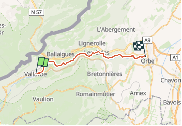
Tocht Te voet van 16 km beschikbaar op Waadland, District du Jura-Nord vaudois, Vallorbe. Deze tocht wordt voorgesteld door famiski.

Beschrijving

Thanks to the natural reserve that has protected the site and its flora since 1970 and has guaranteed calm for the wildlife, this excursion allows the hiker to walk through a preserved natural environment.

Natural pine forests, oregano, wild thyme, juniper and certain orchids can be admired along the path, as well as glacial mills in the upper part of the village of Les Clées. The River Orbe is the habitat for trout, kingfishers, grey herons, chamois and even beavers on the lower part of the trail.

Parking possibilities in Vallorbe or Orbe, busses or trains between the two localities. Restricted schedules at weekends, but the possibility of using PubliCar service. Hikers are requested to follow the path and to respect the diversions. Great care is required on all paths.

Hoogteprofiel

POI's

POI Vallorbe - The Gorge of Orbe - Photo
famiski

Plaatsbepaling

Land:
Switzerland
Regio :
Waadland
Departement/Provincie :
District du Jura-Nord vaudois
Gemeente :
Vallorbe
Locatie:
Unknown
Vertrek:(Dec)
Vertrek:(UTM)
299776 ; 5176510 (32T) N.

Wandeltochten in de omgeving

Tocht Mountainbike Vallorbe - Le Suchet - Photo
Mountainbike
GUIDE+

Mountainbike

Heel gemakkelijk
(1)
Vallorbe, Waadland, District du Jura-Nord vaudois, Switzerland
35 km | 53 km-effort
14h 41min
Ja
Tocht Te voet Vallorbe - Mont d'Orzeires - Le Pont Gare - Photo
Te voet
PRO

Te voet

Gemakkelijk
Vallorbe, Waadland, District du Jura-Nord vaudois, Switzerland
3,2 km | 4,4 km-effort
59min
Neen
Tocht Te voet Ballaigues - Ballaigues-Vallorbe - Photo
Te voet
PRO

Te voet

Gemakkelijk
Ballaigues, Waadland, District du Jura-Nord vaudois, Switzerland
5,1 km | 6,3 km-effort
1h 25min
Neen
Tocht Te voet Vallorbe - Saigne Geret-Les Revines - Photo
Te voet
PRO

Te voet

Gemakkelijk
Vallorbe, Waadland, District du Jura-Nord vaudois, Switzerland
3,5 km | 4,1 km-effort
56min
Neen
Tocht Te voet Juriens - TP Mollendruz - Romainmôtie - Photo
Te voet
PRO

Te voet

Gemakkelijk
Juriens, Waadland, District du Jura-Nord vaudois, Switzerland
7,8 km | 11,6 km-effort
2h 38min
Neen
Tocht Stappen L'Abbaye - La Dent de Vaulion - Photo
Stappen
drarep

Stappen

Zeer moeilijk
(1)
L'Abbaye, Waadland, District du Jura-Nord vaudois, Switzerland
14,6 km | 22 km-effort
4h 31min
Ja
Tocht Stappen Rochejean - Mont d'or  - Photo
Stappen
eltonnermou

Stappen

Gemakkelijk
Rochejean, Bourgondië-Franche-Comté, Doubs, France
11,9 km | 17,5 km-effort
4h 53min
Ja
Tocht Stappen Jougne - La Jougnena - Photo
Stappen
daniellebou

Stappen

Zeer moeilijk
(1)
Jougne, Bourgondië-Franche-Comté, Doubs, France
17,7 km | 24 km-effort
5h 32min
Ja
Tocht Sneeuwschoenen Longevilles-Mont-d'Or - Les Longevilles Mont D'Or CAF - Photo
Sneeuwschoenen
TRIMAILLE

Sneeuwschoenen

Medium
(1)
Longevilles-Mont-d'Or, Bourgondië-Franche-Comté, Doubs, France
8,4 km | 13 km-effort
8h 27min
Ja


Sluiten
Mijn abonnementen