![](/images/other/stat-length.png)
![Tocht Stappen La Vacquerie-et-Saint-Martin-de-Castries - Etape La Vacquerie - Saint Guilhem (nouveau tracé) - Photo](https://media.geolcdn.com/t/1900/400/ext.pjpeg?maxdim=2&url=https%3A%2F%2Fstatic1.geolcdn.com%2Fsiteimages%2Fupload%2Ffiles%2F1553511878bg_sport_marche.png)
Etape La Vacquerie - Saint Guilhem (nouveau tracé)
jpschmitz
Gebruiker
![Lengte](/images/other/stat-length.png)
![Max. hoogte](https://static1.geolcdn.com/siteimages/upload/files/1508320355ic_sort_altitude_max_24dp.png)
![Positief hoogteverschil](https://static1.geolcdn.com/siteimages/upload/files/1508320355ic_sort_den_pos_24dp.png)
![Km-Effort](/images/other/stat-length.png)
![Min. hoogte](https://static1.geolcdn.com/siteimages/upload/files/1508320355ic_sort_altitude_min_24dp.png)
![Negatief hoogteverschil](https://static1.geolcdn.com/siteimages/upload/files/1508320355ic_sort_den_neg_24dp.png)
![Boucle](https://static1.geolcdn.com/siteimages/upload/files/16400158638029165_repeat_loop_refresh_sync_direction_icon.png)
![Stappen](https://static1.geolcdn.com/sitytour/trail-icons/101.png)
5h49
Moeilijkheid : Zeer moeilijk
![Scan deze QR-code om de tocht te openen in de SityTrail-applicatie](https://capi.geolives.com/qq0zvz2zws4bq2lad0pu/sitytour/trails/3592711/qr.png?size=200)
Gratisgps-wandelapplicatie
Over ons
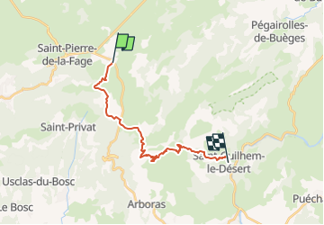
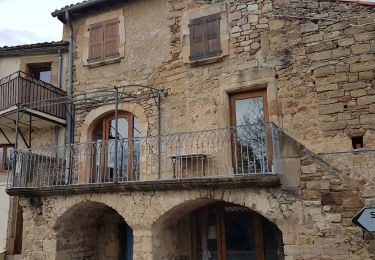
Tocht Stappen van 18,7 km beschikbaar op Occitanië, Hérault, La Vacquerie-et-Saint-Martin-de-Castries. Deze tocht wordt voorgesteld door jpschmitz.
Beschrijving
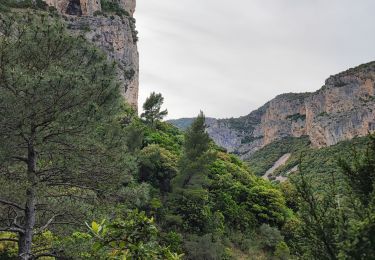
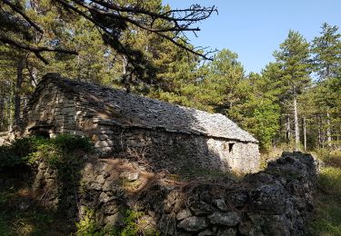
Tracé reconnu de la dernière étape du Chemin de St Guilhem (depuis Aumont-Aubrac). Etape un peu longue donc parcours optimisé, le moins de route ou proximité de route, la montée au Mont St Baudille n'est pas indispensable, il y a déjà beaucoup de descente cumulée (900m). Des tronçons de GR, de PR et non balisés, mais "de bons chemins noirs".
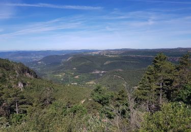
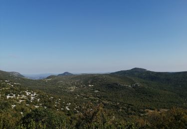
Le panorama sur la Vallée de l'Hérault est plus "valorisant" que l'étape ancienne via Rancas - Natges
Etape fatigante (2 descentes) mais sans difficulté.
Plaatsbepaling
Opmerkingen
Wandeltochten in de omgeving
![Tocht Stappen Saint-Pierre-de-la-Fage - Parlatges - La Vacquerie-et-St-Martin-de-Castries - Photo](https://media.geolcdn.com/t/375/260/076ea1bb-8acb-4fc6-bfb0-1a2a8946e2fc.jpg&format=jpg&maxdim=2)
![Stappen Stappen](https://static1.geolcdn.com/sitytour/trail-icons/101.png)
Stappen
![](/images/other/stat-length.png)
![](https://static1.geolcdn.com/siteimages/upload/files/16400158638029165_repeat_loop_refresh_sync_direction_icon.png)
![Tocht Noords wandelen Saint-Pierre-de-la-Fage - SityTrail - St-Pierre de la Fage - Pas de Cabane - Roqueboude - Photo](https://media.geolcdn.com/t/375/260/f3de2af3-46a7-4008-bd2a-646a63c35c72.jpg&format=jpg&maxdim=2)
![Noords wandelen Noords wandelen](https://static1.geolcdn.com/sitytour/trail-icons/102.png)
Noords wandelen
![](/images/other/stat-length.png)
![](https://static1.geolcdn.com/siteimages/upload/files/16400158638029165_repeat_loop_refresh_sync_direction_icon.png)
![Tocht Noords wandelen Saint-Pierre-de-la-Fage - St-Pierre de la Fage - Pas de Cabane - Roqueboude - Photo](https://media.geolcdn.com/t/375/260/b0257bf0-1019-48a4-89d5-956e560fc262.jpg&format=jpg&maxdim=2)
![Noords wandelen Noords wandelen](https://static1.geolcdn.com/sitytour/trail-icons/102.png)
Noords wandelen
![](/images/other/stat-length.png)
![](https://static1.geolcdn.com/siteimages/upload/files/16400158638029165_repeat_loop_refresh_sync_direction_icon.png)
![Tocht Stappen La Vacquerie-et-Saint-Martin-de-Castries - La Vacquerie St Guilhem - Photo](https://media.geolcdn.com/t/375/260/6776b6fa-32bb-4389-aa74-60e92a5ab663.jpg&format=jpg&maxdim=2)
![Stappen Stappen](https://static1.geolcdn.com/sitytour/trail-icons/101.png)
Stappen
![](/images/other/stat-length.png)
![](https://static1.geolcdn.com/siteimages/upload/files/16400158638029165_repeat_loop_refresh_sync_direction_icon.png)
![Noords wandelen Noords wandelen](https://static1.geolcdn.com/sitytour/trail-icons/102.png)
Noords wandelen
![](/images/other/stat-length.png)
![](https://static1.geolcdn.com/siteimages/upload/files/16400158638029165_repeat_loop_refresh_sync_direction_icon.png)
![Noords wandelen Noords wandelen](https://static1.geolcdn.com/sitytour/trail-icons/102.png)
Noords wandelen
![](/images/other/stat-length.png)
![](https://static1.geolcdn.com/siteimages/upload/files/16400158638029165_repeat_loop_refresh_sync_direction_icon.png)
![Noords wandelen Noords wandelen](https://static1.geolcdn.com/sitytour/trail-icons/102.png)
Noords wandelen
![](/images/other/stat-length.png)
![](https://static1.geolcdn.com/siteimages/upload/files/16400158638029165_repeat_loop_refresh_sync_direction_icon.png)
![Tocht Stappen Saint-Privat - SityTrail - Tour de Carlan - Photo](https://media.geolcdn.com/t/375/260/44e4f369-3e49-43f7-a62d-c17bb6af5e68.jpg&format=jpg&maxdim=2)
![Stappen Stappen](https://static1.geolcdn.com/sitytour/trail-icons/101.png)
Stappen
![](/images/other/stat-length.png)
![](https://static1.geolcdn.com/siteimages/upload/files/16400158638029165_repeat_loop_refresh_sync_direction_icon.png)
![Tocht Stappen Montpeyroux - Mont St Baudile - Photo](https://media.geolcdn.com/t/375/260/d93aa545-f5ab-49f1-9bc2-37f268eb0277.jpg&format=jpg&maxdim=2)
![Stappen Stappen](https://static1.geolcdn.com/sitytour/trail-icons/101.png)
Stappen
![](/images/other/stat-length.png)
![](https://static1.geolcdn.com/siteimages/upload/files/16400158638029165_repeat_loop_refresh_sync_direction_icon.png)