![](/images/other/stat-length.png)
![Tocht Mountainbike Sainte-Marie-sur-Ouche - Ste Marie st Jean de Boeuf Antheuil Retour Canal - Photo](https://media.geolcdn.com/t/1900/400/ext.pjpeg?maxdim=2&url=https%3A%2F%2Fstatic1.geolcdn.com%2Fsiteimages%2Fupload%2Ffiles%2F1524743154velo.jpg)
Ste Marie st Jean de Boeuf Antheuil Retour Canal
mricard
Gebruiker
![Lengte](/images/other/stat-length.png)
Lengte
40 km
![Max. hoogte](https://static1.geolcdn.com/siteimages/upload/files/1508320355ic_sort_altitude_max_24dp.png)
Max. hoogte
632 m
![Positief hoogteverschil](https://static1.geolcdn.com/siteimages/upload/files/1508320355ic_sort_den_pos_24dp.png)
Positief hoogteverschil
640 m
![Km-Effort](/images/other/stat-length.png)
Km-Effort
48 km
![Min. hoogte](https://static1.geolcdn.com/siteimages/upload/files/1508320355ic_sort_altitude_min_24dp.png)
Min. hoogte
282 m
![Negatief hoogteverschil](https://static1.geolcdn.com/siteimages/upload/files/1508320355ic_sort_den_neg_24dp.png)
Negatief hoogteverschil
640 m
![Boucle](https://static1.geolcdn.com/siteimages/upload/files/16400158638029165_repeat_loop_refresh_sync_direction_icon.png)
Boucle
Ja
Datum van aanmaak :
2023-03-16 13:56:45.919
Laatste wijziging :
2023-03-16 13:59:25.941
![Mountainbike](https://static1.geolcdn.com/sitytour/trail-icons/202.png)
3h55
Moeilijkheid : Medium
![Scan deze QR-code om de tocht te openen in de SityTrail-applicatie](https://capi.geolives.com/qq0zvz2zws4bq2lad0pu/sitytour/trails/3586960/qr.png?size=200)
Gratisgps-wandelapplicatie
Over ons
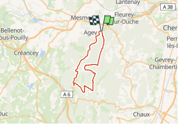
Tocht Mountainbike van 40 km beschikbaar op Bourgondië-Franche-Comté, Côte-d'Or, Sainte-Marie-sur-Ouche. Deze tocht wordt voorgesteld door mricard.
Beschrijving
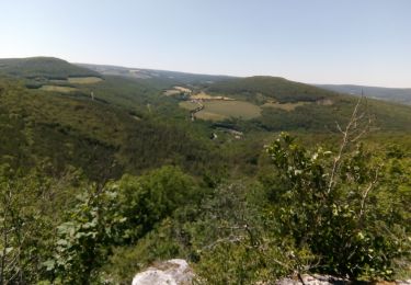
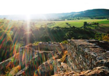
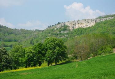
Une quarantaine de kilomètres en vélo. Chemins blancs en forêt avec quelques dénivelés, puis un retour tranquille par le chemin de halage.
Plaatsbepaling
Land:
France
Regio :
Bourgondië-Franche-Comté
Departement/Provincie :
Côte-d'Or
Gemeente :
Sainte-Marie-sur-Ouche
Locatie:
Unknown
Vertrek:(Dec)
Vertrek:(UTM)
635732 ; 5238527 (31T) N.
Opmerkingen
Wandeltochten in de omgeving
![Tocht Stappen Sainte-Marie-sur-Ouche - Pont de Pany - Photo](https://media.geolcdn.com/t/375/260/880c73c5-f480-4d0e-b6d7-7819f4768403.jpg&format=jpg&maxdim=2)
![Stappen Stappen](https://static1.geolcdn.com/sitytour/trail-icons/101.png)
Pont de Pany
Stappen
Gemakkelijk
(1)
Sainte-Marie-sur-Ouche,
Bourgondië-Franche-Comté,
Côte-d'Or,
France
![](/images/other/stat-length.png)
11,4 km | 16 km-effort
3h 19min
![](https://static1.geolcdn.com/siteimages/upload/files/16400158638029165_repeat_loop_refresh_sync_direction_icon.png)
Ja
![Tocht Stappen Urcy - Les environs d'Urcy - Photo](https://media.geolcdn.com/t/375/260/ext.jpg?maxdim=2&url=https%3A%2F%2Fservices.sitytrail.com%2FGeolivesWS%2FDownloadMedia.ashx%3FTrailID%3D104689%26Media%3D8092_1.jpg)
![Stappen Stappen](https://static1.geolcdn.com/sitytour/trail-icons/101.png)
Les environs d'Urcy
Stappen
Moeilijk
(2)
Urcy,
Bourgondië-Franche-Comté,
Côte-d'Or,
France
![](/images/other/stat-length.png)
18,9 km | 27 km-effort
6h 0min
![](https://static1.geolcdn.com/siteimages/upload/files/16400158638029165_repeat_loop_refresh_sync_direction_icon.png)
Neen
![Tocht Stappen Barbirey-sur-Ouche - Le Tour de Barbiriacum - Barbirey sur Ouche - Photo](https://media.geolcdn.com/t/375/260/ext.jpg?maxdim=2&url=https%3A%2F%2Fservices.sitytrail.com%2FGeolivesWS%2FDownloadMedia.ashx%3FTrailID%3D104688%26Media%3D8091_1.jpg)
![Stappen Stappen](https://static1.geolcdn.com/sitytour/trail-icons/101.png)
Le Tour de Barbiriacum - Barbirey sur Ouche
Stappen
Medium
(1)
Barbirey-sur-Ouche,
Bourgondië-Franche-Comté,
Côte-d'Or,
France
![](/images/other/stat-length.png)
10,5 km | 15,9 km-effort
2h 45min
![](https://static1.geolcdn.com/siteimages/upload/files/16400158638029165_repeat_loop_refresh_sync_direction_icon.png)
Ja
![Tocht Stappen Sainte-Marie-sur-Ouche - Belvédères sur la vallée de l'Ouche - Pont de Pany - Photo](https://media.geolcdn.com/t/375/260/ext.jpg?maxdim=2&url=https%3A%2F%2Fservices.sitytrail.com%2FGeolivesWS%2FDownloadMedia.ashx%3FTrailID%3D104685%26Media%3D8088_1.jpg)
![Stappen Stappen](https://static1.geolcdn.com/sitytour/trail-icons/101.png)
Belvédères sur la vallée de l'Ouche - Pont de Pany
Stappen
Moeilijk
(1)
Sainte-Marie-sur-Ouche,
Bourgondië-Franche-Comté,
Côte-d'Or,
France
![](/images/other/stat-length.png)
20 km | 28 km-effort
6h 0min
![](https://static1.geolcdn.com/siteimages/upload/files/16400158638029165_repeat_loop_refresh_sync_direction_icon.png)
Ja
![Tocht Stappen Mâlain - Mâlain - Charmoy - Baulme le Roche - Photo](https://media.geolcdn.com/t/375/260/ext.jpg?maxdim=2&url=https%3A%2F%2Fservices.sitytrail.com%2FGeolivesWS%2FDownloadMedia.ashx%3FTrailID%3D104684%26Media%3D8087_1.jpg)
![Stappen Stappen](https://static1.geolcdn.com/sitytour/trail-icons/101.png)
Mâlain - Charmoy - Baulme le Roche
Stappen
Medium
(3)
Mâlain,
Bourgondië-Franche-Comté,
Côte-d'Or,
France
![](/images/other/stat-length.png)
15,3 km | 21 km-effort
3h 30min
![](https://static1.geolcdn.com/siteimages/upload/files/16400158638029165_repeat_loop_refresh_sync_direction_icon.png)
Ja
![Tocht Stappen Fleurey-sur-Ouche - Le Marathon de Fleurey sur Ouche - Photo](https://media.geolcdn.com/t/375/260/ext.jpg?maxdim=2&url=https%3A%2F%2Fservices.sitytrail.com%2FGeolivesWS%2FDownloadMedia.ashx%3FTrailID%3D104675%26Media%3D8078_1.jpg)
![Stappen Stappen](https://static1.geolcdn.com/sitytour/trail-icons/101.png)
Le Marathon de Fleurey sur Ouche
Stappen
Zeer moeilijk
(1)
Fleurey-sur-Ouche,
Bourgondië-Franche-Comté,
Côte-d'Or,
France
![](/images/other/stat-length.png)
40 km | 54 km-effort
10h 0min
![](https://static1.geolcdn.com/siteimages/upload/files/16400158638029165_repeat_loop_refresh_sync_direction_icon.png)
Ja
![Tocht Elektrische fiets Sainte-Marie-sur-Ouche - Canal de Bourgogne_Etape 6 - Photo](https://media.geolcdn.com/t/375/260/ext.jpg?maxdim=2&url=https%3A%2F%2Fstatic1.geolcdn.com%2Fsiteimages%2Fupload%2Ffiles%2F1524743154velo.jpg)
![Elektrische fiets Elektrische fiets](https://static1.geolcdn.com/sitytour/trail-icons/205.png)
Canal de Bourgogne_Etape 6
Elektrische fiets
Heel gemakkelijk
(1)
Sainte-Marie-sur-Ouche,
Bourgondië-Franche-Comté,
Côte-d'Or,
France
![](/images/other/stat-length.png)
22 km | 23 km-effort
Onbekend
![](https://static1.geolcdn.com/siteimages/upload/files/16400158638029165_repeat_loop_refresh_sync_direction_icon.png)
Neen
![Tocht Te voet Mâlain - Sentier du Mâlain - Photo](https://media.geolcdn.com/t/375/260/ac839600-ec98-4d3e-b54d-0b1e7cde5571.jpeg&format=jpg&maxdim=2)
![Te voet Te voet](https://static1.geolcdn.com/sitytour/trail-icons/100.png)
Sentier du Mâlain
Te voet
Gemakkelijk
Mâlain,
Bourgondië-Franche-Comté,
Côte-d'Or,
France
![](/images/other/stat-length.png)
6,6 km | 10,5 km-effort
2h 22min
![](https://static1.geolcdn.com/siteimages/upload/files/16400158638029165_repeat_loop_refresh_sync_direction_icon.png)
Ja
![Tocht Te voet Fleurey-sur-Ouche - Sentier des Roches d'Orgères - Photo](https://media.geolcdn.com/t/375/260/22d3f48c-a3a5-4f31-ac6b-414d68092044.jpeg&format=jpg&maxdim=2)
![Te voet Te voet](https://static1.geolcdn.com/sitytour/trail-icons/100.png)
Sentier des Roches d'Orgères
Te voet
Gemakkelijk
Fleurey-sur-Ouche,
Bourgondië-Franche-Comté,
Côte-d'Or,
France
![](/images/other/stat-length.png)
4,2 km | 4,8 km-effort
1h 4min
![](https://static1.geolcdn.com/siteimages/upload/files/16400158638029165_repeat_loop_refresh_sync_direction_icon.png)
Ja