![](/images/other/stat-length.png)
![Tocht Stappen Saint-Étienne-de-Tinée - Circuit de Selasse, St Étienne de Tinee - Photo](https://media.geolcdn.com/t/1900/400/86b74c11-3810-443e-a768-1a9016296f59.jpg&format=pjpeg&maxdim=2)
Circuit de Selasse, St Étienne de Tinee
GrouGary
Gebruiker
![Lengte](/images/other/stat-length.png)
![Max. hoogte](https://static1.geolcdn.com/siteimages/upload/files/1508320355ic_sort_altitude_max_24dp.png)
![Positief hoogteverschil](https://static1.geolcdn.com/siteimages/upload/files/1508320355ic_sort_den_pos_24dp.png)
![Km-Effort](/images/other/stat-length.png)
![Min. hoogte](https://static1.geolcdn.com/siteimages/upload/files/1508320355ic_sort_altitude_min_24dp.png)
![Negatief hoogteverschil](https://static1.geolcdn.com/siteimages/upload/files/1508320355ic_sort_den_neg_24dp.png)
![Boucle](https://static1.geolcdn.com/siteimages/upload/files/16400158638029165_repeat_loop_refresh_sync_direction_icon.png)
![Stappen](https://static1.geolcdn.com/sitytour/trail-icons/101.png)
3h14
Moeilijkheid : Gemakkelijk
![Scan deze QR-code om de tocht te openen in de SityTrail-applicatie](https://capi.geolives.com/qq0zvz2zws4bq2lad0pu/sitytour/trails/3580925/qr.png?size=200)
Gratisgps-wandelapplicatie
Over ons
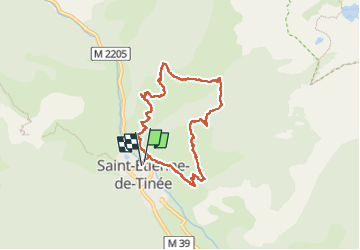
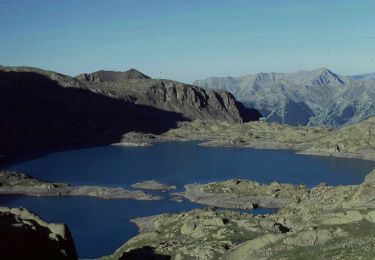
Tocht Stappen van 7,6 km beschikbaar op Provence-Alpes-Côte d'Azur, Alpes-Maritimes, Saint-Étienne-de-Tinée. Deze tocht wordt voorgesteld door GrouGary.
Beschrijving
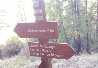
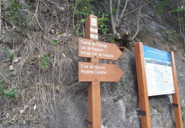
Circuit agréable, passant près des anciennes zones en alpages, anciennes bergeries. Traversée du torrent du Ténibre, sur troncs de bois.
Montée et descente soutenue sur 7,6 km. Belles vues sur les sommets enneigés du Mont Mounier, vallon de Demanldols.
Plaatsbepaling
Opmerkingen
Wandeltochten in de omgeving
![Tocht Stappen Saint-Étienne-de-Tinée - MERCANTOUR - Lac de rabuons - Photo](https://media.geolcdn.com/t/375/260/9be970a9-36fb-4800-8850-f3d8a283d146.jpg&format=jpg&maxdim=2)
![Stappen Stappen](https://static1.geolcdn.com/sitytour/trail-icons/101.png)
Stappen
![](/images/other/stat-length.png)
![](https://static1.geolcdn.com/siteimages/upload/files/16400158638029165_repeat_loop_refresh_sync_direction_icon.png)
![Tocht Stappen Saint-Étienne-de-Tinée - Mont Ténibre en boucle depuis Saint Etienne de Tinée - Photo](https://media.geolcdn.com/t/375/260/ext.jpg?maxdim=2&url=https%3A%2F%2Fservices.sitytrail.com%2FGeolivesWS%2FDownloadMedia.ashx%3FTrailID%3D316962%26Media%3D16081_1.jpg)
![Stappen Stappen](https://static1.geolcdn.com/sitytour/trail-icons/101.png)
Stappen
![](/images/other/stat-length.png)
![](https://static1.geolcdn.com/siteimages/upload/files/16400158638029165_repeat_loop_refresh_sync_direction_icon.png)
![Tocht Stappen Saint-Étienne-de-Tinée - Lacs de Rabuons et Chaffour - Photo](https://media.geolcdn.com/t/375/260/3c095966-4d41-4343-af9e-eff2f1957790.jpg&format=jpg&maxdim=2)
![Stappen Stappen](https://static1.geolcdn.com/sitytour/trail-icons/101.png)
Stappen
![](/images/other/stat-length.png)
![](https://static1.geolcdn.com/siteimages/upload/files/16400158638029165_repeat_loop_refresh_sync_direction_icon.png)
![Tocht Stappen Saint-Étienne-de-Tinée - Refuge du Rabuons -- Mt Ténibre A/R -- St Etienne de Tinée - Photo](https://media.geolcdn.com/t/375/260/994ef0cf-20db-466f-991e-cc6124ac559b.jpg&format=jpg&maxdim=2)
![Stappen Stappen](https://static1.geolcdn.com/sitytour/trail-icons/101.png)
Stappen
![](/images/other/stat-length.png)
![](https://static1.geolcdn.com/siteimages/upload/files/16400158638029165_repeat_loop_refresh_sync_direction_icon.png)
![Tocht Te voet Saint-Étienne-de-Tinée - Circuit du Bois d'Anelle - Photo](https://media.geolcdn.com/t/375/260/33170b65-b2a2-4258-939b-53929311e4fe.jpeg&format=jpg&maxdim=2)
![Te voet Te voet](https://static1.geolcdn.com/sitytour/trail-icons/100.png)
Te voet
![](/images/other/stat-length.png)
![](https://static1.geolcdn.com/siteimages/upload/files/16400158638029165_repeat_loop_refresh_sync_direction_icon.png)
![Tocht Te voet Saint-Étienne-de-Tinée - Circuit de Selasse - Photo](https://media.geolcdn.com/t/375/260/dfb717e2-6ad9-4c5c-8a23-b53a05088fa8.jpeg&format=jpg&maxdim=2)
![Te voet Te voet](https://static1.geolcdn.com/sitytour/trail-icons/100.png)
Te voet
![](/images/other/stat-length.png)
![](https://static1.geolcdn.com/siteimages/upload/files/16400158638029165_repeat_loop_refresh_sync_direction_icon.png)
![Tocht Te voet Saint-Étienne-de-Tinée - Cime de la Bercha - Photo](https://media.geolcdn.com/t/375/260/06e4d46f-e317-406d-bd2c-01041e541c38.jpeg&format=jpg&maxdim=2)
![Te voet Te voet](https://static1.geolcdn.com/sitytour/trail-icons/100.png)
Te voet
![](/images/other/stat-length.png)
![](https://static1.geolcdn.com/siteimages/upload/files/16400158638029165_repeat_loop_refresh_sync_direction_icon.png)
![Tocht Te voet Saint-Étienne-de-Tinée - Chemin de l'Energie - Etape 3 - Photo](https://media.geolcdn.com/t/375/260/45dc2ef9-a27b-439a-8012-c03ab217c2f9.jpeg&format=jpg&maxdim=2)
![Te voet Te voet](https://static1.geolcdn.com/sitytour/trail-icons/100.png)
Te voet
![](/images/other/stat-length.png)
![](https://static1.geolcdn.com/siteimages/upload/files/16400158638029165_repeat_loop_refresh_sync_direction_icon.png)
![Tocht Te voet Saint-Étienne-de-Tinée - Mont Ténibre - Photo](https://media.geolcdn.com/t/375/260/e4d2ef1c-7332-48ac-8d35-d330e68b6f30.jpeg&format=jpg&maxdim=2)
![Te voet Te voet](https://static1.geolcdn.com/sitytour/trail-icons/100.png)
Te voet
![](/images/other/stat-length.png)
![](https://static1.geolcdn.com/siteimages/upload/files/16400158638029165_repeat_loop_refresh_sync_direction_icon.png)