![](/images/other/stat-length.png)
![Tocht Stappen Montesquieu-des-Albères - Montesquieu des Albères. De Terradelles à Trompette basse. - Photo](https://media.geolcdn.com/t/1900/400/ext.pjpeg?maxdim=2&url=https%3A%2F%2Fstatic1.geolcdn.com%2Fsiteimages%2Fupload%2Ffiles%2F1553511878bg_sport_marche.png)
Montesquieu des Albères. De Terradelles à Trompette basse.
Denis Delay
Gebruiker
![Lengte](/images/other/stat-length.png)
Lengte
13,3 km
![Max. hoogte](https://static1.geolcdn.com/siteimages/upload/files/1508320355ic_sort_altitude_max_24dp.png)
Max. hoogte
374 m
![Positief hoogteverschil](https://static1.geolcdn.com/siteimages/upload/files/1508320355ic_sort_den_pos_24dp.png)
Positief hoogteverschil
413 m
![Km-Effort](/images/other/stat-length.png)
Km-Effort
18,8 km
![Min. hoogte](https://static1.geolcdn.com/siteimages/upload/files/1508320355ic_sort_altitude_min_24dp.png)
Min. hoogte
81 m
![Negatief hoogteverschil](https://static1.geolcdn.com/siteimages/upload/files/1508320355ic_sort_den_neg_24dp.png)
Negatief hoogteverschil
413 m
![Boucle](https://static1.geolcdn.com/siteimages/upload/files/16400158638029165_repeat_loop_refresh_sync_direction_icon.png)
Boucle
Ja
Datum van aanmaak :
2023-03-04 12:01:03.0
Laatste wijziging :
2023-03-04 12:01:05.279
![Stappen](https://static1.geolcdn.com/sitytour/trail-icons/101.png)
4h17
Moeilijkheid : Medium
![Scan deze QR-code om de tocht te openen in de SityTrail-applicatie](https://capi.geolives.com/qq0zvz2zws4bq2lad0pu/sitytour/trails/3572784/qr.png?size=200)
Gratisgps-wandelapplicatie
Over ons
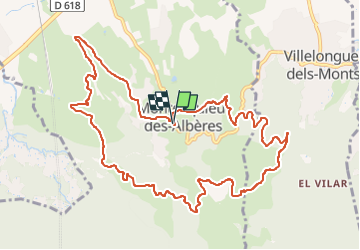
Tocht Stappen van 13,3 km beschikbaar op Occitanië, Pyrénées-Orientales, Montesquieu-des-Albères. Deze tocht wordt voorgesteld door Denis Delay.
Beschrijving
Montesquieu des Albères. École, Correc de la Vallauria, Terradells, treze vents, mas Pericot, trompette basse, della font. École.
On peut raccourcir en revenant directement du mas Pericot à Montesquieu. ( 2 km et 200 m de moins).
Plaatsbepaling
Land:
France
Regio :
Occitanië
Departement/Provincie :
Pyrénées-Orientales
Gemeente :
Montesquieu-des-Albères
Locatie:
Unknown
Vertrek:(Dec)
Vertrek:(UTM)
490151 ; 4707253 (31T) N.
Opmerkingen
Wandeltochten in de omgeving
![Tocht Stappen Les Cluses - LES CLUSES 66 - Photo](https://media.geolcdn.com/t/375/260/ext.jpg?maxdim=2&url=https%3A%2F%2Fstatic1.geolcdn.com%2Fsiteimages%2Fupload%2Ffiles%2F1553511878bg_sport_marche.png)
![Stappen Stappen](https://static1.geolcdn.com/sitytour/trail-icons/101.png)
LES CLUSES 66
Stappen
Gemakkelijk
(9)
Les Cluses,
Occitanië,
Pyrénées-Orientales,
France
![](/images/other/stat-length.png)
9,4 km | 12,8 km-effort
1h 50min
![](https://static1.geolcdn.com/siteimages/upload/files/16400158638029165_repeat_loop_refresh_sync_direction_icon.png)
Ja
![Tocht Stappen Laroque-des-Albères - 66 LAROQUE DES ALBERES (maison) SOREDE, par pistes DFCI AL12 et 19, mas del Ca et mas Manere, Itin.16 - Photo](https://media.geolcdn.com/t/375/260/ext.jpg?maxdim=2&url=https%3A%2F%2Fservices.sitytrail.com%2FGeolivesWS%2FDownloadMedia.ashx%3FTrailID%3D585179%26Media%3D20160616145650.jpg)
![Stappen Stappen](https://static1.geolcdn.com/sitytour/trail-icons/101.png)
66 LAROQUE DES ALBERES (maison) SOREDE, par pistes DFCI AL12 et 19, mas del C...
Stappen
Medium
(1)
Laroque-des-Albères,
Occitanië,
Pyrénées-Orientales,
France
![](/images/other/stat-length.png)
11,2 km | 15,3 km-effort
2h 5min
![](https://static1.geolcdn.com/siteimages/upload/files/16400158638029165_repeat_loop_refresh_sync_direction_icon.png)
Ja
![Tocht Stappen L'Albère - SAINT-JEAN-D'ALBERE 66 - PUIG de Sant Christau par le coll de Sant Joan - Photo](https://media.geolcdn.com/t/375/260/ext.jpg?maxdim=2&url=https%3A%2F%2Fservices.sitytrail.com%2FGeolivesWS%2FDownloadMedia.ashx%3FTrailID%3D452444%26Media%3D20150731170134.jpg)
![Stappen Stappen](https://static1.geolcdn.com/sitytour/trail-icons/101.png)
SAINT-JEAN-D'ALBERE 66 - PUIG de Sant Christau par le coll de Sant Joan
Stappen
Moeilijk
(1)
L'Albère,
Occitanië,
Pyrénées-Orientales,
France
![](/images/other/stat-length.png)
10,1 km | 17 km-effort
2h 46min
![](https://static1.geolcdn.com/siteimages/upload/files/16400158638029165_repeat_loop_refresh_sync_direction_icon.png)
Ja
![Tocht Stappen Montesquieu-des-Albères - MONTESQUIEU-DES-ALBERES 66 - Les Agouillous - les chemins de l'eau dans les Albères - Photo](https://media.geolcdn.com/t/375/260/ext.jpg?maxdim=2&url=https%3A%2F%2Fservices.sitytrail.com%2FGeolivesWS%2FDownloadMedia.ashx%3FTrailID%3D451257%26Media%3D20150728182708.jpg)
![Stappen Stappen](https://static1.geolcdn.com/sitytour/trail-icons/101.png)
MONTESQUIEU-DES-ALBERES 66 - Les Agouillous - les chemins de l'eau dans les A...
Stappen
Medium
(1)
Montesquieu-des-Albères,
Occitanië,
Pyrénées-Orientales,
France
![](/images/other/stat-length.png)
12,7 km | 13,9 km-effort
2h 16min
![](https://static1.geolcdn.com/siteimages/upload/files/16400158638029165_repeat_loop_refresh_sync_direction_icon.png)
Ja
![Tocht Stappen Le Boulou - LES THERMES DU BOULOU - 66 - Albera viva - PUIG de l'Estella - Photo](https://media.geolcdn.com/t/375/260/ext.jpg?maxdim=2&url=https%3A%2F%2Fservices.sitytrail.com%2FGeolivesWS%2FDownloadMedia.ashx%3FTrailID%3D443397%26Media%3D20150709200943.jpg)
![Stappen Stappen](https://static1.geolcdn.com/sitytour/trail-icons/101.png)
LES THERMES DU BOULOU - 66 - Albera viva - PUIG de l'Estella
Stappen
Medium
(2)
Le Boulou,
Occitanië,
Pyrénées-Orientales,
France
![](/images/other/stat-length.png)
7,3 km | 11,4 km-effort
1h 32min
![](https://static1.geolcdn.com/siteimages/upload/files/16400158638029165_repeat_loop_refresh_sync_direction_icon.png)
Ja
![Tocht Stappen Laroque-des-Albères - Col-Ullat Pic-aureille_Terrain - Photo](https://media.geolcdn.com/t/375/260/ext.jpg?maxdim=2&url=https%3A%2F%2Fservices.sitytrail.com%2FGeolivesWS%2FDownloadMedia.ashx%3FTrailID%3D221622%26Media%3Dfix__20130916174240.jpg)
![Stappen Stappen](https://static1.geolcdn.com/sitytour/trail-icons/101.png)
Col-Ullat Pic-aureille_Terrain
Stappen
Medium
(1)
Laroque-des-Albères,
Occitanië,
Pyrénées-Orientales,
France
![](/images/other/stat-length.png)
11,2 km | 23 km-effort
4h 47min
![](https://static1.geolcdn.com/siteimages/upload/files/16400158638029165_repeat_loop_refresh_sync_direction_icon.png)
Ja
![Tocht Stappen Brouilla - RP66 BROUILLA - BANYULS DELS ASPRES - par les bords de Tech et Vignobles - le 31.03.2017 - Photo](https://media.geolcdn.com/t/375/260/ext.jpg?maxdim=2&url=https%3A%2F%2Fstatic1.geolcdn.com%2Fsiteimages%2Fupload%2Ffiles%2F1553511878bg_sport_marche.png)
![Stappen Stappen](https://static1.geolcdn.com/sitytour/trail-icons/101.png)
RP66 BROUILLA - BANYULS DELS ASPRES - par les bords de Tech et Vignobles - le...
Stappen
Gemakkelijk
(3)
Brouilla,
Occitanië,
Pyrénées-Orientales,
France
![](/images/other/stat-length.png)
7,5 km | 8,3 km-effort
1h 26min
![](https://static1.geolcdn.com/siteimages/upload/files/16400158638029165_repeat_loop_refresh_sync_direction_icon.png)
Ja
![Tocht Stappen Laroque-des-Albères - LAROQUE des A. 66 - Le puits à neige - Casot del Guarda - Photo](https://media.geolcdn.com/t/375/260/ext.jpg?maxdim=2&url=https%3A%2F%2Fstatic1.geolcdn.com%2Fsiteimages%2Fupload%2Ffiles%2F1553511878bg_sport_marche.png)
![Stappen Stappen](https://static1.geolcdn.com/sitytour/trail-icons/101.png)
LAROQUE des A. 66 - Le puits à neige - Casot del Guarda
Stappen
Medium
(2)
Laroque-des-Albères,
Occitanië,
Pyrénées-Orientales,
France
![](/images/other/stat-length.png)
12,3 km | 19 km-effort
2h 17min
![](https://static1.geolcdn.com/siteimages/upload/files/16400158638029165_repeat_loop_refresh_sync_direction_icon.png)
Ja
![Tocht Stappen Laroque-des-Albères - LAROQUE boucle village - Photo](https://media.geolcdn.com/t/375/260/ext.jpg?maxdim=2&url=https%3A%2F%2Fstatic1.geolcdn.com%2Fsiteimages%2Fupload%2Ffiles%2F1553511878bg_sport_marche.png)
![Stappen Stappen](https://static1.geolcdn.com/sitytour/trail-icons/101.png)
LAROQUE boucle village
Stappen
Heel gemakkelijk
(2)
Laroque-des-Albères,
Occitanië,
Pyrénées-Orientales,
France
![](/images/other/stat-length.png)
5,2 km | 6,1 km-effort
53min
![](https://static1.geolcdn.com/siteimages/upload/files/16400158638029165_repeat_loop_refresh_sync_direction_icon.png)
Ja