![](/images/other/stat-length.png)
![Tocht Lopen Le Havre - Footing 2 Le Havre - Photo](https://media.geolcdn.com/t/1900/400/ext.pjpeg?maxdim=2&url=https%3A%2F%2Fstatic1.geolcdn.com%2Fsiteimages%2Fupload%2Ffiles%2F1524743154running.jpg)
Footing 2 Le Havre
yannick-p
Gebruiker
![Lengte](/images/other/stat-length.png)
Lengte
7,7 km
![Max. hoogte](https://static1.geolcdn.com/siteimages/upload/files/1508320355ic_sort_altitude_max_24dp.png)
Max. hoogte
11 m
![Positief hoogteverschil](https://static1.geolcdn.com/siteimages/upload/files/1508320355ic_sort_den_pos_24dp.png)
Positief hoogteverschil
52 m
![Km-Effort](/images/other/stat-length.png)
Km-Effort
8,4 km
![Min. hoogte](https://static1.geolcdn.com/siteimages/upload/files/1508320355ic_sort_altitude_min_24dp.png)
Min. hoogte
1 m
![Negatief hoogteverschil](https://static1.geolcdn.com/siteimages/upload/files/1508320355ic_sort_den_neg_24dp.png)
Negatief hoogteverschil
53 m
![Boucle](https://static1.geolcdn.com/siteimages/upload/files/16400158638029165_repeat_loop_refresh_sync_direction_icon.png)
Boucle
Ja
Datum van aanmaak :
2023-02-28 19:29:11.207
Laatste wijziging :
2023-02-28 19:45:20.016
![Lopen](https://static1.geolcdn.com/sitytour/trail-icons/103.png)
45m
Moeilijkheid : Gemakkelijk
![Scan deze QR-code om de tocht te openen in de SityTrail-applicatie](https://capi.geolives.com/qq0zvz2zws4bq2lad0pu/sitytour/trails/3568870/qr.png?size=200)
Gratisgps-wandelapplicatie
Over ons
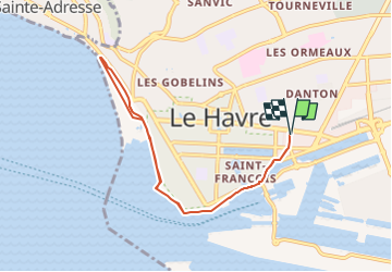
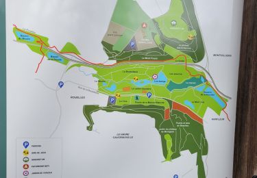
Tocht Lopen van 7,7 km beschikbaar op Normandië, Seine-Maritime, Le Havre. Deze tocht wordt voorgesteld door yannick-p.
Beschrijving
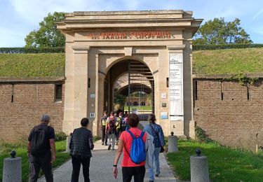
Petite sortie footing tranquille à partir du centre ville du Havre, direction le port puis la plage. Pas de difficulté de circulation, parcours sur une large esplanade avec vue sur le large et les côtes du Calvados.
Plaatsbepaling
Land:
France
Regio :
Normandië
Departement/Provincie :
Seine-Maritime
Gemeente :
Le Havre
Locatie:
Unknown
Vertrek:(Dec)
Vertrek:(UTM)
291374 ; 5486154 (31U) N.
Opmerkingen
Wandeltochten in de omgeving
![Tocht Stappen Le Havre - Découvrir Le Havre - Photo](https://media.geolcdn.com/t/375/260/ext.jpg?maxdim=2&url=https%3A%2F%2Fservices.sitytrail.com%2FGeolivesWS%2FDownloadMedia.ashx%3FTrailID%3D173067%26Media%3D14597_6.jpg)
![Stappen Stappen](https://static1.geolcdn.com/sitytour/trail-icons/101.png)
Découvrir Le Havre
Stappen
Moeilijk
(1)
Le Havre,
Normandië,
Seine-Maritime,
France
![](/images/other/stat-length.png)
14,2 km | 17 km-effort
3h 30min
![](https://static1.geolcdn.com/siteimages/upload/files/16400158638029165_repeat_loop_refresh_sync_direction_icon.png)
Ja
![Tocht Te voet Fontaine-la-Mallet - Les Bassins des Vallées - Photo](https://media.geolcdn.com/t/375/260/ce57ffe6-f4ea-486c-bc79-47861158f9a7.jpeg&format=jpg&maxdim=2)
![Te voet Te voet](https://static1.geolcdn.com/sitytour/trail-icons/100.png)
Les Bassins des Vallées
Te voet
Gemakkelijk
Fontaine-la-Mallet,
Normandië,
Seine-Maritime,
France
![](/images/other/stat-length.png)
5,1 km | 6 km-effort
1h 21min
![](https://static1.geolcdn.com/siteimages/upload/files/16400158638029165_repeat_loop_refresh_sync_direction_icon.png)
Neen
![Tocht Te voet Le Havre - Autour du Cap - Photo](https://media.geolcdn.com/t/375/260/5d7ac9de-0a46-49c7-8cfc-4f8d63e71135.jpeg&format=jpg&maxdim=2)
![Te voet Te voet](https://static1.geolcdn.com/sitytour/trail-icons/100.png)
Autour du Cap
Te voet
Gemakkelijk
Le Havre,
Normandië,
Seine-Maritime,
France
![](/images/other/stat-length.png)
4,8 km | 5,9 km-effort
1h 20min
![](https://static1.geolcdn.com/siteimages/upload/files/16400158638029165_repeat_loop_refresh_sync_direction_icon.png)
Neen
![Tocht Stappen Le Havre - 076-05-Le Havre A-Midi 9km - Photo](https://media.geolcdn.com/t/375/260/d02b20a6-0462-4a95-b9ff-2029e3ab179d.jpg&format=jpg&maxdim=2)
![Stappen Stappen](https://static1.geolcdn.com/sitytour/trail-icons/101.png)
076-05-Le Havre A-Midi 9km
Stappen
Gemakkelijk
(1)
Le Havre,
Normandië,
Seine-Maritime,
France
![](/images/other/stat-length.png)
8,8 km | 11,5 km-effort
2h 49min
![](https://static1.geolcdn.com/siteimages/upload/files/16400158638029165_repeat_loop_refresh_sync_direction_icon.png)
Ja
![Tocht Te voet Le Havre - Parc de Rouelles - GR - 16-09-2024 - Photo](https://media.geolcdn.com/t/375/260/ext.jpg?maxdim=2&url=https%3A%2F%2Fstatic1.geolcdn.com%2Fsiteimages%2Fupload%2Ffiles%2F1545311037marcheuse_200dpi.jpg)
![Te voet Te voet](https://static1.geolcdn.com/sitytour/trail-icons/100.png)
Parc de Rouelles - GR - 16-09-2024
Te voet
Gemakkelijk
(1)
Le Havre,
Normandië,
Seine-Maritime,
France
![](/images/other/stat-length.png)
9,4 km | 11,6 km-effort
2h 37min
![](https://static1.geolcdn.com/siteimages/upload/files/16400158638029165_repeat_loop_refresh_sync_direction_icon.png)
Ja
![Tocht Stappen Le Havre - le havre parcs - Photo](https://media.geolcdn.com/t/375/260/96da9185-4728-4bbd-baaf-9500c4363780.jpg&format=jpg&maxdim=2)
![Stappen Stappen](https://static1.geolcdn.com/sitytour/trail-icons/101.png)
le havre parcs
Stappen
Moeilijk
Le Havre,
Normandië,
Seine-Maritime,
France
![](/images/other/stat-length.png)
12,1 km | 14,5 km-effort
3h 25min
![](https://static1.geolcdn.com/siteimages/upload/files/16400158638029165_repeat_loop_refresh_sync_direction_icon.png)
Ja
![Tocht Stappen Le Havre - parc rouelles mini pas - Photo](https://media.geolcdn.com/t/375/260/4828ec3b-0ba5-48a6-a7b6-2d96d2df242a.jpg&format=jpg&maxdim=2)
![Stappen Stappen](https://static1.geolcdn.com/sitytour/trail-icons/101.png)
parc rouelles mini pas
Stappen
Gemakkelijk
Le Havre,
Normandië,
Seine-Maritime,
France
![](/images/other/stat-length.png)
3,1 km | 3,6 km-effort
49min
![](https://static1.geolcdn.com/siteimages/upload/files/16400158638029165_repeat_loop_refresh_sync_direction_icon.png)
Ja
![Tocht Stappen Le Havre - Le havre front de mer - Photo](https://media.geolcdn.com/t/375/260/3dca226e-3bee-4d91-903b-81db7c6a4339.jpg&format=jpg&maxdim=2)
![Stappen Stappen](https://static1.geolcdn.com/sitytour/trail-icons/101.png)
Le havre front de mer
Stappen
Medium
Le Havre,
Normandië,
Seine-Maritime,
France
![](/images/other/stat-length.png)
8,2 km | 9,7 km-effort
3h 14min
![](https://static1.geolcdn.com/siteimages/upload/files/16400158638029165_repeat_loop_refresh_sync_direction_icon.png)
Ja
![Tocht Noords wandelen Sainte-Adresse - Le Havre plage - Photo](https://media.geolcdn.com/t/375/260/74f6e575-20b6-423b-8e0f-ed4b954898f3.jpg&format=jpg&maxdim=2)
![Noords wandelen Noords wandelen](https://static1.geolcdn.com/sitytour/trail-icons/102.png)
Le Havre plage
Noords wandelen
Heel gemakkelijk
Sainte-Adresse,
Normandië,
Seine-Maritime,
France
![](/images/other/stat-length.png)
7,2 km | 7,8 km-effort
2h 0min
![](https://static1.geolcdn.com/siteimages/upload/files/16400158638029165_repeat_loop_refresh_sync_direction_icon.png)
Neen