![](/images/other/stat-length.png)
![Tocht Stappen Eyzerac - Eyzerac Lavoirs 14km - Photo](https://media.geolcdn.com/t/1900/400/ext.pjpeg?maxdim=2&url=https%3A%2F%2Fstatic1.geolcdn.com%2Fsiteimages%2Fupload%2Ffiles%2F1553511878bg_sport_marche.png)
Eyzerac Lavoirs 14km
YV24
Gebruiker
![Lengte](/images/other/stat-length.png)
Lengte
13,3 km
![Max. hoogte](https://static1.geolcdn.com/siteimages/upload/files/1508320355ic_sort_altitude_max_24dp.png)
Max. hoogte
256 m
![Positief hoogteverschil](https://static1.geolcdn.com/siteimages/upload/files/1508320355ic_sort_den_pos_24dp.png)
Positief hoogteverschil
223 m
![Km-Effort](/images/other/stat-length.png)
Km-Effort
16,3 km
![Min. hoogte](https://static1.geolcdn.com/siteimages/upload/files/1508320355ic_sort_altitude_min_24dp.png)
Min. hoogte
162 m
![Negatief hoogteverschil](https://static1.geolcdn.com/siteimages/upload/files/1508320355ic_sort_den_neg_24dp.png)
Negatief hoogteverschil
223 m
![Boucle](https://static1.geolcdn.com/siteimages/upload/files/16400158638029165_repeat_loop_refresh_sync_direction_icon.png)
Boucle
Ja
Datum van aanmaak :
2018-04-09 00:00:00.0
Laatste wijziging :
2020-02-04 14:19:05.048
![Stappen](https://static1.geolcdn.com/sitytour/trail-icons/101.png)
3h34
Moeilijkheid : Gemakkelijk
![Scan deze QR-code om de tocht te openen in de SityTrail-applicatie](https://capi.geolives.com/qq0zvz2zws4bq2lad0pu/sitytour/trails/356403/qr.png?size=200)
Gratisgps-wandelapplicatie
Over ons
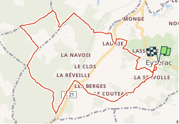
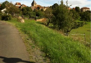
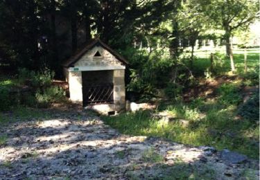
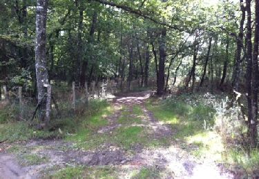
Tocht Stappen van 13,3 km beschikbaar op Nieuw-Aquitanië, Dordogne, Eyzerac. Deze tocht wordt voorgesteld door YV24.
Beschrijving
Selon PDIPR. ATTENTION, balisage "léger" le long de la N21, soyez prudent le long des glissières de bord de cette route. Tracé varié, impraticable après fortes pluies
Plaatsbepaling
Land:
France
Regio :
Nieuw-Aquitanië
Departement/Provincie :
Dordogne
Gemeente :
Eyzerac
Locatie:
Unknown
Vertrek:(Dec)
Vertrek:(UTM)
337189 ; 5028200 (31T) N.
Opmerkingen
Wandeltochten in de omgeving
![Tocht Stappen Corgnac-sur-l'Isle - Boucle de Puyfebert à Corgnac sur L'isle (24) - Photo](https://media.geolcdn.com/t/375/260/473ca2ea-b417-4ef5-b016-acee12c3b097.jpg&format=jpg&maxdim=2)
![Stappen Stappen](https://static1.geolcdn.com/sitytour/trail-icons/101.png)
Boucle de Puyfebert à Corgnac sur L'isle (24)
Stappen
Heel gemakkelijk
(1)
Corgnac-sur-l'Isle,
Nieuw-Aquitanië,
Dordogne,
France
![](/images/other/stat-length.png)
13,4 km | 16,5 km-effort
3h 27min
![](https://static1.geolcdn.com/siteimages/upload/files/16400158638029165_repeat_loop_refresh_sync_direction_icon.png)
Ja
![Tocht Mountainbike Thiviers - Thiviers vtt - Photo](https://media.geolcdn.com/t/375/260/df34d907-768b-4b26-a7b5-5ec7cdc86a99.jpg&format=jpg&maxdim=2)
![Mountainbike Mountainbike](https://static1.geolcdn.com/sitytour/trail-icons/202.png)
Thiviers vtt
Mountainbike
Heel gemakkelijk
Thiviers,
Nieuw-Aquitanië,
Dordogne,
France
![](/images/other/stat-length.png)
48 km | 58 km-effort
6h 2min
![](https://static1.geolcdn.com/siteimages/upload/files/16400158638029165_repeat_loop_refresh_sync_direction_icon.png)
Ja
![Tocht Stappen Eyzerac - La Servolle 2 - Photo](https://media.geolcdn.com/t/375/260/ext.jpg?maxdim=2&url=https%3A%2F%2Fservices.sitytrail.com%2FGeolivesWS%2FDownloadMedia.ashx%3FTrailID%3D226050%26Media%3D20131008110344.jpg)
![Stappen Stappen](https://static1.geolcdn.com/sitytour/trail-icons/101.png)
La Servolle 2
Stappen
Gemakkelijk
Eyzerac,
Nieuw-Aquitanië,
Dordogne,
France
![](/images/other/stat-length.png)
12,4 km | 14,9 km-effort
3h 16min
![](https://static1.geolcdn.com/siteimages/upload/files/16400158638029165_repeat_loop_refresh_sync_direction_icon.png)
Ja
![Tocht Stappen Corgnac-sur-l'Isle - Pouzol - Photo](https://media.geolcdn.com/t/375/260/ext.jpg?maxdim=2&url=https%3A%2F%2Fservices.sitytrail.com%2FGeolivesWS%2FDownloadMedia.ashx%3FTrailID%3D225982%26Media%3D20131006115329.jpg)
![Stappen Stappen](https://static1.geolcdn.com/sitytour/trail-icons/101.png)
Pouzol
Stappen
Gemakkelijk
Corgnac-sur-l'Isle,
Nieuw-Aquitanië,
Dordogne,
France
![](/images/other/stat-length.png)
11,5 km | 14,3 km-effort
3h 4min
![](https://static1.geolcdn.com/siteimages/upload/files/16400158638029165_repeat_loop_refresh_sync_direction_icon.png)
Ja
![Tocht Stappen Corgnac-sur-l'Isle - Boucle Pouzol par Corgnac - Photo](https://media.geolcdn.com/t/375/260/ext.jpg?maxdim=2&url=https%3A%2F%2Fservices.sitytrail.com%2FGeolivesWS%2FDownloadMedia.ashx%3FTrailID%3D225801%26Media%3D20131007121141.jpg)
![Stappen Stappen](https://static1.geolcdn.com/sitytour/trail-icons/101.png)
Boucle Pouzol par Corgnac
Stappen
Gemakkelijk
(1)
Corgnac-sur-l'Isle,
Nieuw-Aquitanië,
Dordogne,
France
![](/images/other/stat-length.png)
11,3 km | 14,1 km-effort
2h 46min
![](https://static1.geolcdn.com/siteimages/upload/files/16400158638029165_repeat_loop_refresh_sync_direction_icon.png)
Ja
![Tocht Stappen Vaunac - Vaunac-St Chavit - Photo](https://media.geolcdn.com/t/375/260/ext.jpg?maxdim=2&url=https%3A%2F%2Fservices.sitytrail.com%2FGeolivesWS%2FDownloadMedia.ashx%3FTrailID%3D226520%26Media%3D20131011113305.jpg)
![Stappen Stappen](https://static1.geolcdn.com/sitytour/trail-icons/101.png)
Vaunac-St Chavit
Stappen
Heel gemakkelijk
Vaunac,
Nieuw-Aquitanië,
Dordogne,
France
![](/images/other/stat-length.png)
9,9 km | 12,6 km-effort
2h 39min
![](https://static1.geolcdn.com/siteimages/upload/files/16400158638029165_repeat_loop_refresh_sync_direction_icon.png)
Ja
![Tocht Stappen Nantheuil - Nantheuil route - Photo](https://media.geolcdn.com/t/375/260/ext.jpg?maxdim=2&url=https%3A%2F%2Fstatic1.geolcdn.com%2Fsiteimages%2Fupload%2Ffiles%2F1553511878bg_sport_marche.png)
![Stappen Stappen](https://static1.geolcdn.com/sitytour/trail-icons/101.png)
Nantheuil route
Stappen
Gemakkelijk
Nantheuil,
Nieuw-Aquitanië,
Dordogne,
France
![](/images/other/stat-length.png)
8 km | 9,6 km-effort
1h 39min
![](https://static1.geolcdn.com/siteimages/upload/files/16400158638029165_repeat_loop_refresh_sync_direction_icon.png)
Neen
![Tocht Stappen Nantheuil - Boucle observatoire allongée Nantheuil - Photo](https://media.geolcdn.com/t/375/260/efe1fbe8-4080-47ca-9be9-dfb6227d2dee.jpg&format=jpg&maxdim=2)
![Stappen Stappen](https://static1.geolcdn.com/sitytour/trail-icons/101.png)
Boucle observatoire allongée Nantheuil
Stappen
Medium
Nantheuil,
Nieuw-Aquitanië,
Dordogne,
France
![](/images/other/stat-length.png)
11,2 km | 14,2 km-effort
2h 52min
![](https://static1.geolcdn.com/siteimages/upload/files/16400158638029165_repeat_loop_refresh_sync_direction_icon.png)
Ja
![Tocht Stappen Eyzerac - Eyzerat - Photo](https://media.geolcdn.com/t/375/260/ext.jpg?maxdim=2&url=https%3A%2F%2Fstatic1.geolcdn.com%2Fsiteimages%2Fupload%2Ffiles%2F1553511878bg_sport_marche.png)
![Stappen Stappen](https://static1.geolcdn.com/sitytour/trail-icons/101.png)
Eyzerat
Stappen
Medium
Eyzerac,
Nieuw-Aquitanië,
Dordogne,
France
![](/images/other/stat-length.png)
12,8 km | 15,7 km-effort
3h 3min
![](https://static1.geolcdn.com/siteimages/upload/files/16400158638029165_repeat_loop_refresh_sync_direction_icon.png)
Ja