![](/images/other/stat-length.png)
![Tocht Stappen Laruns - Cirque de Moundelhs - Photo](https://media.geolcdn.com/t/1900/400/ext.pjpeg?maxdim=2&url=https%3A%2F%2Fstatic1.geolcdn.com%2Fsiteimages%2Fupload%2Ffiles%2F1553511878bg_sport_marche.png)
Cirque de Moundelhs
DuMarsan
Gebruiker
![Lengte](/images/other/stat-length.png)
![Max. hoogte](https://static1.geolcdn.com/siteimages/upload/files/1508320355ic_sort_altitude_max_24dp.png)
![Positief hoogteverschil](https://static1.geolcdn.com/siteimages/upload/files/1508320355ic_sort_den_pos_24dp.png)
![Km-Effort](/images/other/stat-length.png)
![Min. hoogte](https://static1.geolcdn.com/siteimages/upload/files/1508320355ic_sort_altitude_min_24dp.png)
![Negatief hoogteverschil](https://static1.geolcdn.com/siteimages/upload/files/1508320355ic_sort_den_neg_24dp.png)
![Boucle](https://static1.geolcdn.com/siteimages/upload/files/16400158638029165_repeat_loop_refresh_sync_direction_icon.png)
![Stappen](https://static1.geolcdn.com/sitytour/trail-icons/101.png)
3h57
Moeilijkheid : Gemakkelijk
![Scan deze QR-code om de tocht te openen in de SityTrail-applicatie](https://capi.geolives.com/qq0zvz2zws4bq2lad0pu/sitytour/trails/356192/qr.png?size=200)
Gratisgps-wandelapplicatie
Over ons
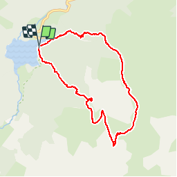
Tocht Stappen van 9 km beschikbaar op Nieuw-Aquitanië, Pyrénées-Atlantiques, Laruns. Deze tocht wordt voorgesteld door DuMarsan.
Beschrijving
Départ:Lac de BIOUS ARTIGUE
Du parking supérieur, prendre la piste qui longe le lac sur 300m.A la hauteur d'un refuge forestier (blanc) sur la droite
.Continuer prendre la piste forestière qui part sur la droite jusqu'à traverser un ruisseau puis continuer jusqu'à la sortie de la forêt vers 1800m.En dessous se trouve le petit lac de Moundelhs. Continuer jusqu'à être dans le cirque au pieds du pic d'Ossau.Traverser le cirque par la gauche et prendre un sentier sinueux qui monte vers le col de Moundelhs. Au col prendre la pente abrupte qui mène au chemin en direction du col de Suzon. Une fois sur le chemin prendre à droite vers le parking de Bious Artigues.
Plaatsbepaling
Opmerkingen
Wandeltochten in de omgeving
![Tocht Stappen Laruns - Ossau : Tour des lacs d’Ayous - Photo](https://media.geolcdn.com/t/375/260/506674d0-c4fd-4a53-a5f4-01b6386a74ed.jpg&format=jpg&maxdim=2)
![Stappen Stappen](https://static1.geolcdn.com/sitytour/trail-icons/101.png)
Stappen
![](/images/other/stat-length.png)
![](https://static1.geolcdn.com/siteimages/upload/files/16400158638029165_repeat_loop_refresh_sync_direction_icon.png)
![Tocht Stappen Laruns - Tour des Lacs d'Ayous en boucle depuis Bious-Artigues - Photo](https://media.geolcdn.com/t/375/260/ext.jpg?maxdim=2&url=https%3A%2F%2Fservices.sitytrail.com%2FGeolivesWS%2FDownloadMedia.ashx%3FTrailID%3D109944%26Media%3D5004_1.jpg)
![Stappen Stappen](https://static1.geolcdn.com/sitytour/trail-icons/101.png)
Stappen
![](/images/other/stat-length.png)
![](https://static1.geolcdn.com/siteimages/upload/files/16400158638029165_repeat_loop_refresh_sync_direction_icon.png)
![Tocht Stappen Laruns - Tour des Lacs d'Ayous + Pic des Moines (2349m) - Photo](https://media.geolcdn.com/t/375/260/ext.jpg?maxdim=2&url=https%3A%2F%2Fservices.sitytrail.com%2FGeolivesWS%2FDownloadMedia.ashx%3FTrailID%3D103574%26Media%3D5886_1.jpg)
![Stappen Stappen](https://static1.geolcdn.com/sitytour/trail-icons/101.png)
Stappen
![](/images/other/stat-length.png)
![](https://static1.geolcdn.com/siteimages/upload/files/16400158638029165_repeat_loop_refresh_sync_direction_icon.png)
![Tocht Stappen Laruns - GR 10 - U - Photo](https://media.geolcdn.com/t/375/260/ext.jpg?maxdim=2&url=https%3A%2F%2Fstatic1.geolcdn.com%2Fsiteimages%2Fupload%2Ffiles%2F1553511878bg_sport_marche.png)
![Stappen Stappen](https://static1.geolcdn.com/sitytour/trail-icons/101.png)
Stappen
![](/images/other/stat-length.png)
![](https://static1.geolcdn.com/siteimages/upload/files/16400158638029165_repeat_loop_refresh_sync_direction_icon.png)
![Tocht Stappen Laruns - chemin des fenetres - Photo](https://media.geolcdn.com/t/375/260/ext.jpg?maxdim=2&url=https%3A%2F%2Fstatic1.geolcdn.com%2Fsiteimages%2Fupload%2Ffiles%2F1553511878bg_sport_marche.png)
![Stappen Stappen](https://static1.geolcdn.com/sitytour/trail-icons/101.png)
Stappen
![](/images/other/stat-length.png)
![](https://static1.geolcdn.com/siteimages/upload/files/16400158638029165_repeat_loop_refresh_sync_direction_icon.png)
![Tocht sport Laruns - Gabas Etsaut - Photo](https://media.geolcdn.com/t/375/260/7c21af10-1d22-476f-b216-9aa4a04acfe4.jpg&format=jpg&maxdim=2)
sport
![](/images/other/stat-length.png)
![](https://static1.geolcdn.com/siteimages/upload/files/16400158638029165_repeat_loop_refresh_sync_direction_icon.png)
![Tocht Stappen Laruns - Lac d’Aule et Col du Turin Garié - Photo](https://media.geolcdn.com/t/375/260/5b20a947-15d2-453e-9b90-ef85d05c68e0.jpg&format=jpg&maxdim=2)
![Stappen Stappen](https://static1.geolcdn.com/sitytour/trail-icons/101.png)
Stappen
![](/images/other/stat-length.png)
![](https://static1.geolcdn.com/siteimages/upload/files/16400158638029165_repeat_loop_refresh_sync_direction_icon.png)
![Tocht Stappen Laruns - lacs d'Ayous - Photo](https://media.geolcdn.com/t/375/260/dd136f74-904d-495b-bdb2-8389a76c47db.jpg&format=jpg&maxdim=2)
![Stappen Stappen](https://static1.geolcdn.com/sitytour/trail-icons/101.png)
Stappen
![](/images/other/stat-length.png)
![](https://static1.geolcdn.com/siteimages/upload/files/16400158638029165_repeat_loop_refresh_sync_direction_icon.png)
![Tocht Te voet Laruns - Voie d'OssauB - Photo](https://media.geolcdn.com/t/375/260/7ccbfa81-52aa-450a-9353-320987110b82.jpeg&format=jpg&maxdim=2)
![Te voet Te voet](https://static1.geolcdn.com/sitytour/trail-icons/100.png)
Te voet
![](/images/other/stat-length.png)
![](https://static1.geolcdn.com/siteimages/upload/files/16400158638029165_repeat_loop_refresh_sync_direction_icon.png)