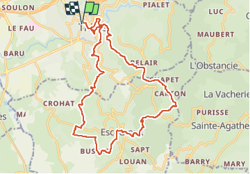
![](/images/other/stat-length.png)
![Tocht Stappen Thiers - Thiers_Couteliere_3 - Photo](https://media.geolcdn.com/t/1900/400/dcb28280-70fa-4637-9a62-befd9280dc1e.jpg&format=pjpeg&maxdim=2)
Thiers_Couteliere_3
jagarnier
Gebruiker GUIDE
![Lengte](/images/other/stat-length.png)
![Max. hoogte](https://static1.geolcdn.com/siteimages/upload/files/1508320355ic_sort_altitude_max_24dp.png)
![Positief hoogteverschil](https://static1.geolcdn.com/siteimages/upload/files/1508320355ic_sort_den_pos_24dp.png)
![Km-Effort](/images/other/stat-length.png)
![Min. hoogte](https://static1.geolcdn.com/siteimages/upload/files/1508320355ic_sort_altitude_min_24dp.png)
![Negatief hoogteverschil](https://static1.geolcdn.com/siteimages/upload/files/1508320355ic_sort_den_neg_24dp.png)
![Boucle](https://static1.geolcdn.com/siteimages/upload/files/16400158638029165_repeat_loop_refresh_sync_direction_icon.png)
![Stappen](https://static1.geolcdn.com/sitytour/trail-icons/101.png)
7h00
Moeilijkheid : Moeilijk
![Scan deze QR-code om de tocht te openen in de SityTrail-applicatie](https://capi.geolives.com/qq0zvz2zws4bq2lad0pu/sitytour/trails/3554056/qr.png?size=200)
Gratisgps-wandelapplicatie
Over ons
Tocht Stappen van 21 km beschikbaar op Auvergne-Rhône-Alpes, Puy-de-Dôme, Thiers. Deze tocht wordt voorgesteld door jagarnier.
Beschrijving
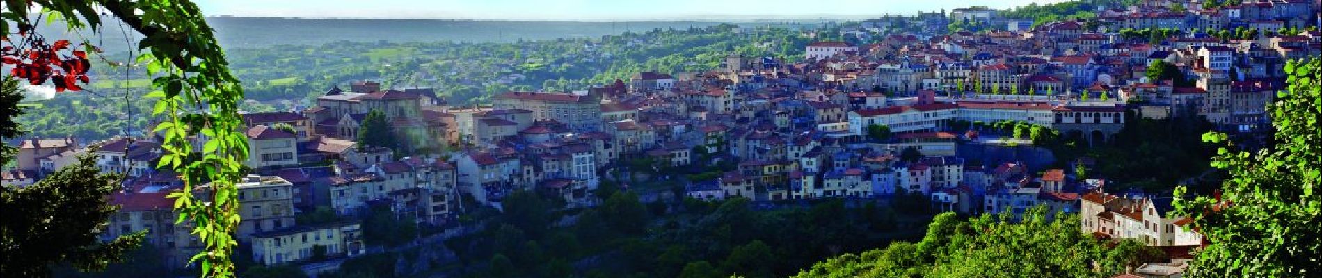
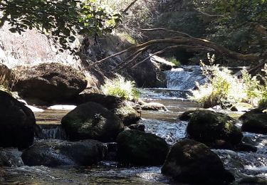
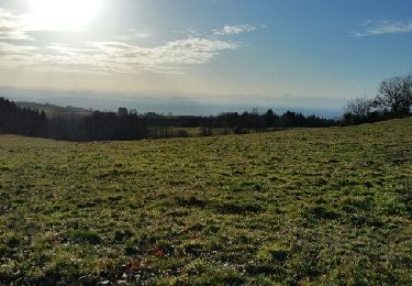
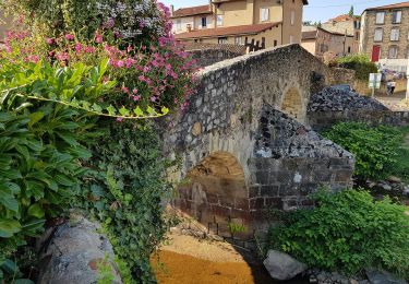
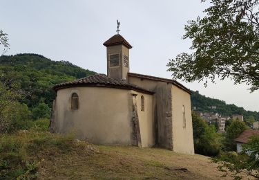
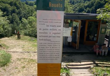
Thiers, depuis 6 siècles, a été marqué par ses couteliers, le GMIT (Groupe des Marcheurs Indépendants de Thiers) leur dédie une randonnée avec un parcours recentré sur la région thiernoise, la Vallée des rouets, la Durolle, la cité médiévale, les paysages du Livradois Forez et du val de DORE, ...
Plaatsbepaling
Opmerkingen
Wandeltochten in de omgeving
![Tocht Stappen Thiers - Thiers_Enfer_Rouets - Photo](https://media.geolcdn.com/t/375/260/d30f62f6-c2be-42d4-8327-b960a8e7ad10.jpg&format=jpg&maxdim=2)
![Stappen Stappen](https://static1.geolcdn.com/sitytour/trail-icons/101.png)
Stappen
![](/images/other/stat-length.png)
![](https://static1.geolcdn.com/siteimages/upload/files/16400158638029165_repeat_loop_refresh_sync_direction_icon.png)
![Tocht Stappen Thiers - Thiers_Horts - Photo](https://media.geolcdn.com/t/375/260/a517b9ce-72b2-4eb8-b533-599543dd0dbf.jpg&format=jpg&maxdim=2)
![Stappen Stappen](https://static1.geolcdn.com/sitytour/trail-icons/101.png)
Stappen
![](/images/other/stat-length.png)
![](https://static1.geolcdn.com/siteimages/upload/files/16400158638029165_repeat_loop_refresh_sync_direction_icon.png)
![Tocht Stappen Saint-Rémy-sur-Durolle - 2016-1-26- Chabrol - Photo](https://media.geolcdn.com/t/375/260/ext.jpg?maxdim=2&url=https%3A%2F%2Fservices.sitytrail.com%2FGeolivesWS%2FDownloadMedia.ashx%3FTrailID%3D517769%26Media%3Dfix__20160126160133.jpg)
![Stappen Stappen](https://static1.geolcdn.com/sitytour/trail-icons/101.png)
Stappen
![](/images/other/stat-length.png)
![](https://static1.geolcdn.com/siteimages/upload/files/16400158638029165_repeat_loop_refresh_sync_direction_icon.png)
![Tocht Te voet Thiers - Thiers - Château de Vaulx - Photo](https://media.geolcdn.com/t/375/260/d9376438-b0f9-4c05-849e-307a520c5889.jpeg&format=jpg&maxdim=2)
![Te voet Te voet](https://static1.geolcdn.com/sitytour/trail-icons/100.png)
Te voet
![](/images/other/stat-length.png)
![](https://static1.geolcdn.com/siteimages/upload/files/16400158638029165_repeat_loop_refresh_sync_direction_icon.png)
![Tocht Te voet Thiers - Château de Vaulx - Thiers - Photo](https://media.geolcdn.com/t/375/260/a3f04348-13bb-4f13-9b8b-5e876d0aa9b1.jpeg&format=jpg&maxdim=2)
![Te voet Te voet](https://static1.geolcdn.com/sitytour/trail-icons/100.png)
Te voet
![](/images/other/stat-length.png)
![](https://static1.geolcdn.com/siteimages/upload/files/16400158638029165_repeat_loop_refresh_sync_direction_icon.png)
![Tocht Te voet Dorat - Le sentier de Néron - Photo](https://media.geolcdn.com/t/375/260/c929225b-d926-40dd-9fd6-d6dd547a4945.jpeg&format=jpg&maxdim=2)
![Te voet Te voet](https://static1.geolcdn.com/sitytour/trail-icons/100.png)
Te voet
![](/images/other/stat-length.png)
![](https://static1.geolcdn.com/siteimages/upload/files/16400158638029165_repeat_loop_refresh_sync_direction_icon.png)
![Tocht Te voet Thiers - De l'Enfer aux Rouets - Photo](https://media.geolcdn.com/t/375/260/929c0432-0df8-4b9b-9f47-7f14e14b443e.jpeg&format=jpg&maxdim=2)
![Te voet Te voet](https://static1.geolcdn.com/sitytour/trail-icons/100.png)
Te voet
![](/images/other/stat-length.png)
![](https://static1.geolcdn.com/siteimages/upload/files/16400158638029165_repeat_loop_refresh_sync_direction_icon.png)
![Tocht Te voet Escoutoux - Les Terrasses de la Dore - Photo](https://media.geolcdn.com/t/375/260/35672727-a85c-4fd8-ae6f-8544d7faa0f5.jpeg&format=jpg&maxdim=2)
![Te voet Te voet](https://static1.geolcdn.com/sitytour/trail-icons/100.png)
Te voet
![](/images/other/stat-length.png)
![](https://static1.geolcdn.com/siteimages/upload/files/16400158638029165_repeat_loop_refresh_sync_direction_icon.png)
![Tocht Stappen Thiers - Ballet des rouets - Photo](https://media.geolcdn.com/t/375/260/810cc98b-159f-4c9b-8e0c-49a79d616f43.jpg&format=jpg&maxdim=2)
![Stappen Stappen](https://static1.geolcdn.com/sitytour/trail-icons/101.png)
Stappen
![](/images/other/stat-length.png)
![](https://static1.geolcdn.com/siteimages/upload/files/16400158638029165_repeat_loop_refresh_sync_direction_icon.png)