![](/images/other/stat-length.png)
![Tocht Stappen Rennes-sur-Loue - Rennes sur Loue - Photo](https://media.geolcdn.com/t/1900/400/eb24f96c-dd7d-40a0-a849-4c5b681e042a.jpg&format=pjpeg&maxdim=2)
Rennes sur Loue
eltonnermou
Gebruiker
![Lengte](/images/other/stat-length.png)
![Max. hoogte](https://static1.geolcdn.com/siteimages/upload/files/1508320355ic_sort_altitude_max_24dp.png)
![Positief hoogteverschil](https://static1.geolcdn.com/siteimages/upload/files/1508320355ic_sort_den_pos_24dp.png)
![Km-Effort](/images/other/stat-length.png)
![Min. hoogte](https://static1.geolcdn.com/siteimages/upload/files/1508320355ic_sort_altitude_min_24dp.png)
![Negatief hoogteverschil](https://static1.geolcdn.com/siteimages/upload/files/1508320355ic_sort_den_neg_24dp.png)
![Boucle](https://static1.geolcdn.com/siteimages/upload/files/16400158638029165_repeat_loop_refresh_sync_direction_icon.png)
![Stappen](https://static1.geolcdn.com/sitytour/trail-icons/101.png)
4h07
Moeilijkheid : Medium
![Scan deze QR-code om de tocht te openen in de SityTrail-applicatie](https://capi.geolives.com/qq0zvz2zws4bq2lad0pu/sitytour/trails/3545933/qr.png?size=200)
Gratisgps-wandelapplicatie
Over ons
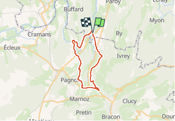
Tocht Stappen van 21 km beschikbaar op Bourgondië-Franche-Comté, Doubs, Rennes-sur-Loue. Deze tocht wordt voorgesteld door eltonnermou.
Beschrijving
distance réelle 20 km : erreur due à la recherche de passage
A 12 km du départ une table pour pique-nique sur le lieu des ruines du château de Vaulgrenant. En cas de crue de la Loue, entre Port-Lesney et Rennes le sentier tracé est impraticable, au poteau balise à l'entrée du chemin des gabelous existe une variante flèchée qui évite le bord de rivière.
parking secteur de la mairie de Rennes.
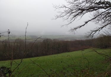
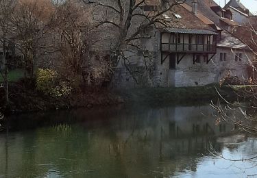
Belle randonnée avec de beaux points de vue sur la vallée de la Loue.
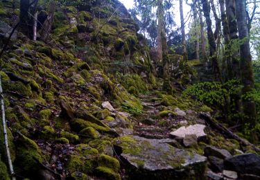
Dans ces espaces escarpés laissez vous surprendre par la faune sauvage (chamois, chevreuil, ...) et très proche de l'arrivée observé ces arbres abattus de manière particulière : les castors ...
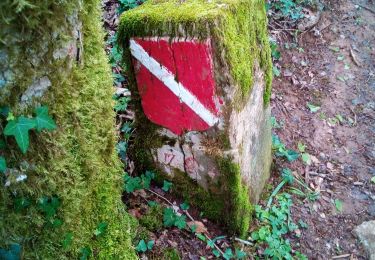
Plaatsbepaling
Opmerkingen
Wandeltochten in de omgeving
![Tocht Te voet Port-Lesney - Val d'Amour - Photo](https://media.geolcdn.com/t/375/260/5cfc7e14-9f65-4fa1-a053-b82c7404ed99.jpeg&format=jpg&maxdim=2)
![Te voet Te voet](https://static1.geolcdn.com/sitytour/trail-icons/100.png)
Te voet
![](/images/other/stat-length.png)
![](https://static1.geolcdn.com/siteimages/upload/files/16400158638029165_repeat_loop_refresh_sync_direction_icon.png)
![Tocht Stappen Paroy - paroy - Photo](https://media.geolcdn.com/t/375/260/378ec14a-d696-40da-bfca-933f8dfdc99c.jpg&format=jpg&maxdim=2)
![Stappen Stappen](https://static1.geolcdn.com/sitytour/trail-icons/101.png)
Stappen
![](/images/other/stat-length.png)
![](https://static1.geolcdn.com/siteimages/upload/files/16400158638029165_repeat_loop_refresh_sync_direction_icon.png)
![Tocht Te voet Port-Lesney - Chemin des Gabelous - Photo](https://media.geolcdn.com/t/375/260/09807b3d-6dc5-4f94-a372-f894abc0bac2.jpeg&format=jpg&maxdim=2)
![Te voet Te voet](https://static1.geolcdn.com/sitytour/trail-icons/100.png)
Te voet
![](/images/other/stat-length.png)
![](https://static1.geolcdn.com/siteimages/upload/files/16400158638029165_repeat_loop_refresh_sync_direction_icon.png)
![Tocht Stappen Ivrey - Nans sous ste Anne - Photo](https://media.geolcdn.com/t/375/260/2c1907f9-25f3-456f-93de-39df357245b8.jpg&format=jpg&maxdim=2)
![Stappen Stappen](https://static1.geolcdn.com/sitytour/trail-icons/101.png)
Stappen
![](/images/other/stat-length.png)
![](https://static1.geolcdn.com/siteimages/upload/files/16400158638029165_repeat_loop_refresh_sync_direction_icon.png)
![Tocht Stappen Ivrey - Ivrey - Mr Poupet 7 juillet 20250 CAF - Photo](https://media.geolcdn.com/t/375/260/5f9423aa-ea9d-41da-ade4-234e9fd3c0f0.jpg&format=jpg&maxdim=2)
![Stappen Stappen](https://static1.geolcdn.com/sitytour/trail-icons/101.png)
Stappen
![](/images/other/stat-length.png)
![](https://static1.geolcdn.com/siteimages/upload/files/16400158638029165_repeat_loop_refresh_sync_direction_icon.png)
![Tocht Stappen Champagne-sur-Loue - champagne sur Loue - Photo](https://media.geolcdn.com/t/375/260/dd8d5849-8e09-4521-8614-bfddc1d7c7ae.jpg&format=jpg&maxdim=2)
![Stappen Stappen](https://static1.geolcdn.com/sitytour/trail-icons/101.png)
Stappen
![](/images/other/stat-length.png)
![](https://static1.geolcdn.com/siteimages/upload/files/16400158638029165_repeat_loop_refresh_sync_direction_icon.png)
![Tocht Stappen Ivrey - Mont POUPET SALINS LES BAINS - Photo](https://media.geolcdn.com/t/375/260/86549112-5193-40f7-bfd7-a4668e312ffe.jpg&format=jpg&maxdim=2)
![Stappen Stappen](https://static1.geolcdn.com/sitytour/trail-icons/101.png)
Stappen
![](/images/other/stat-length.png)
![](https://static1.geolcdn.com/siteimages/upload/files/16400158638029165_repeat_loop_refresh_sync_direction_icon.png)
![Tocht Stappen Port-Lesney - Vaulgrenan depuis Port Lesney. - Photo](https://media.geolcdn.com/t/375/260/888b9e37-2427-47c6-a53b-dfa1373cf9fa.jpg&format=jpg&maxdim=2)
![Stappen Stappen](https://static1.geolcdn.com/sitytour/trail-icons/101.png)
Stappen
![](/images/other/stat-length.png)
![](https://static1.geolcdn.com/siteimages/upload/files/16400158638029165_repeat_loop_refresh_sync_direction_icon.png)
![Tocht Stappen La Chapelle-sur-Furieuse - Chapelle sur Furieuse 20241024 - Photo](https://media.geolcdn.com/t/375/260/ext.jpg?maxdim=2&url=https%3A%2F%2Fstatic1.geolcdn.com%2Fsiteimages%2Fupload%2Ffiles%2F1553511878bg_sport_marche.png)
![Stappen Stappen](https://static1.geolcdn.com/sitytour/trail-icons/101.png)
Stappen
![](/images/other/stat-length.png)
![](https://static1.geolcdn.com/siteimages/upload/files/16400158638029165_repeat_loop_refresh_sync_direction_icon.png)