![](/images/other/stat-length.png)
![Tocht Mountainbike Theux - 20141008 Forestia - Photo](https://media.geolcdn.com/t/1900/400/ext.pjpeg?maxdim=2&url=https%3A%2F%2Fservices.sitytrail.com%2FGeolivesWS%2FDownloadMedia.ashx%3FTrailID%3D352277%26Media%3D20141008180830.jpg)
20141008 Forestia
Yeyette VTT team
Plus vî, plus sot
![Lengte](/images/other/stat-length.png)
Lengte
22 km
![Max. hoogte](https://static1.geolcdn.com/siteimages/upload/files/1508320355ic_sort_altitude_max_24dp.png)
Max. hoogte
419 m
![Positief hoogteverschil](https://static1.geolcdn.com/siteimages/upload/files/1508320355ic_sort_den_pos_24dp.png)
Positief hoogteverschil
405 m
![Km-Effort](/images/other/stat-length.png)
Km-Effort
27 km
![Min. hoogte](https://static1.geolcdn.com/siteimages/upload/files/1508320355ic_sort_altitude_min_24dp.png)
Min. hoogte
223 m
![Negatief hoogteverschil](https://static1.geolcdn.com/siteimages/upload/files/1508320355ic_sort_den_neg_24dp.png)
Negatief hoogteverschil
405 m
![Boucle](https://static1.geolcdn.com/siteimages/upload/files/16400158638029165_repeat_loop_refresh_sync_direction_icon.png)
Boucle
Ja
Datum van aanmaak :
2014-12-10 00:00:00.0
Laatste wijziging :
2014-12-10 00:00:00.0
![Mountainbike](https://static1.geolcdn.com/sitytour/trail-icons/202.png)
1h45
Moeilijkheid : Onbekend
![Scan deze QR-code om de tocht te openen in de SityTrail-applicatie](https://capi.geolives.com/qq0zvz2zws4bq2lad0pu/sitytour/trails/352277/qr.png?size=200)
Gratisgps-wandelapplicatie
Over ons
Tocht Mountainbike van 22 km beschikbaar op Wallonië, Luik, Theux. Deze tocht wordt voorgesteld door Yeyette VTT team.
Beschrijving
Une toute tranquille vers la Charmille. Deux montées costaudes sur le retour. A faire en sens contraire ?
Plaatsbepaling
Land:
Belgium
Regio :
Wallonië
Departement/Provincie :
Luik
Gemeente :
Theux
Locatie:
Theux
Vertrek:(Dec)
Vertrek:(UTM)
696562 ; 5599198 (31U) N.
Opmerkingen
Wandeltochten in de omgeving
![Tocht Stappen Theux - Theux - Natura 2000, des sites qui valent le détour - LG22 - Photo](https://media.geolcdn.com/t/375/260/ext.jpg?maxdim=2&url=https%3A%2F%2Fservices.sitytrail.com%2FGeolivesWS%2FDownloadMedia.ashx%3FTrailID%3D612638%26Media%3D53072597-f13a-4b1e-b213-a2c1df094f1f.JPG)
![Stappen Stappen](https://static1.geolcdn.com/sitytour/trail-icons/101.png)
Theux - Natura 2000, des sites qui valent le détour - LG22
Stappen
Medium
(6)
Theux,
Wallonië,
Luik,
Belgium
![](/images/other/stat-length.png)
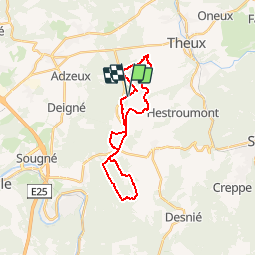
12,7 km | 16,8 km-effort
3h 31min
![](https://static1.geolcdn.com/siteimages/upload/files/16400158638029165_repeat_loop_refresh_sync_direction_icon.png)
Ja
![Tocht Stappen Theux - RB-Lg-24_La-Reid_via-racc-1 - Photo](https://media.geolcdn.com/t/375/260/ext.jpg?maxdim=2&url=https%3A%2F%2Fservices.sitytrail.com%2FGeolivesWS%2FDownloadMedia.ashx%3FTrailID%3D400924%26Media%3De46f0d15-4872-47d2-9c6f-9e812d51cefb.jpg)
![Stappen Stappen](https://static1.geolcdn.com/sitytour/trail-icons/101.png)
RB-Lg-24_La-Reid_via-racc-1
Stappen
(11)
Theux,
Wallonië,
Luik,
Belgium
![](/images/other/stat-length.png)
15,9 km | 21 km-effort
4h 50min
![](https://static1.geolcdn.com/siteimages/upload/files/16400158638029165_repeat_loop_refresh_sync_direction_icon.png)
Ja
![Tocht Stappen Theux - RB-Lg-24_La-Reid - Photo](https://media.geolcdn.com/t/375/260/ext.jpg?maxdim=2&url=https%3A%2F%2Fservices.sitytrail.com%2FGeolivesWS%2FDownloadMedia.ashx%3FTrailID%3D400922%26Media%3De46f0d15-4872-47d2-9c6f-9e812d51cefb.jpg)
![Stappen Stappen](https://static1.geolcdn.com/sitytour/trail-icons/101.png)
![Tocht Stappen Aywaille - RB-Lg-12 - De Sougné-Remouchamps à Deigné et retour - Photo](https://media.geolcdn.com/t/375/260/ext.jpg?maxdim=2&url=https%3A%2F%2Fservices.sitytrail.com%2FGeolivesWS%2FDownloadMedia.ashx%3FTrailID%3D179570%26Media%3D1074d230-2da3-49cf-8210-a5f6b46fd870.jpg)
![Stappen Stappen](https://static1.geolcdn.com/sitytour/trail-icons/101.png)
RB-Lg-12 - De Sougné-Remouchamps à Deigné et retour
Stappen
Moeilijk
(9)
Aywaille,
Wallonië,
Luik,
Belgium
![](/images/other/stat-length.png)
24 km | 34 km-effort
7h 39min
![](https://static1.geolcdn.com/siteimages/upload/files/16400158638029165_repeat_loop_refresh_sync_direction_icon.png)
Ja
![Tocht Stappen Aywaille - Petite remontée du Ninglispo - Photo](https://media.geolcdn.com/t/375/260/ext.jpg?maxdim=2&url=https%3A%2F%2Fservices.sitytrail.com%2FGeolivesWS%2FDownloadMedia.ashx%3FTrailID%3D536482%26Media%3D20160311161707.jpg)
![Stappen Stappen](https://static1.geolcdn.com/sitytour/trail-icons/101.png)
Petite remontée du Ninglispo
Stappen
Medium
(9)
Aywaille,
Wallonië,
Luik,
Belgium
![](/images/other/stat-length.png)
6,7 km | 9,7 km-effort
2h 11min
![](https://static1.geolcdn.com/siteimages/upload/files/16400158638029165_repeat_loop_refresh_sync_direction_icon.png)
Ja
![Tocht Stappen Aywaille - RB-LG-12 - Raccourci 2 - Photo](https://media.geolcdn.com/t/375/260/ext.jpg?maxdim=2&url=https%3A%2F%2Fservices.sitytrail.com%2FGeolivesWS%2FDownloadMedia.ashx%3FTrailID%3D209433%26Media%3D1f1ef83d-c0c7-4521-b15a-02c5e9e7c1f1.jpg)
![Stappen Stappen](https://static1.geolcdn.com/sitytour/trail-icons/101.png)
RB-LG-12 - Raccourci 2
Stappen
Moeilijk
(6)
Aywaille,
Wallonië,
Luik,
Belgium
![](/images/other/stat-length.png)
17 km | 25 km-effort
5h 46min
![](https://static1.geolcdn.com/siteimages/upload/files/16400158638029165_repeat_loop_refresh_sync_direction_icon.png)
Ja
![Tocht Stappen Theux - RF-Lg-08_Franchimont_Grande-boucle - Photo](https://media.geolcdn.com/t/375/260/ext.jpg?maxdim=2&url=https%3A%2F%2Fstatic1.geolcdn.com%2Fsiteimages%2Fupload%2Ffiles%2F1553511878bg_sport_marche.png)
![Stappen Stappen](https://static1.geolcdn.com/sitytour/trail-icons/101.png)
RF-Lg-08_Franchimont_Grande-boucle
Stappen
Heel gemakkelijk
(6)
Theux,
Wallonië,
Luik,
Belgium
![](/images/other/stat-length.png)
10,8 km | 14,6 km-effort
3h 9min
![](https://static1.geolcdn.com/siteimages/upload/files/16400158638029165_repeat_loop_refresh_sync_direction_icon.png)
Ja
![Tocht Stappen Sprimont - Banneux - Rouge Thier - Adzeux - Photo](https://media.geolcdn.com/t/375/260/0f185ab2-d29a-4b49-b676-7a8415068951.jpg&format=jpg&maxdim=2)
![Stappen Stappen](https://static1.geolcdn.com/sitytour/trail-icons/101.png)
Banneux - Rouge Thier - Adzeux
Stappen
Gemakkelijk
(4)
Sprimont,
Wallonië,
Luik,
Belgium
![](/images/other/stat-length.png)
9,1 km | 11,3 km-effort
2h 34min
![](https://static1.geolcdn.com/siteimages/upload/files/16400158638029165_repeat_loop_refresh_sync_direction_icon.png)
Ja
![Tocht Stappen Theux - Theux Natura 2000 château Franchimont - Photo](https://media.geolcdn.com/t/375/260/c750767f-f208-4264-8684-0a202377691f.jpg&format=jpg&maxdim=2)
![Stappen Stappen](https://static1.geolcdn.com/sitytour/trail-icons/101.png)
Theux Natura 2000 château Franchimont
Stappen
Medium
(2)
Theux,
Wallonië,
Luik,
Belgium
![](/images/other/stat-length.png)
13,1 km | 17,3 km-effort
3h 0min
![](https://static1.geolcdn.com/siteimages/upload/files/16400158638029165_repeat_loop_refresh_sync_direction_icon.png)
Ja