![](/images/other/stat-length.png)
![Tocht Stappen Vexin-sur-Epte - Chateau Sur Epte 13 4 - Photo](https://media.geolcdn.com/t/1900/400/ext.pjpeg?maxdim=2&url=https%3A%2F%2Fstatic1.geolcdn.com%2Fsiteimages%2Fupload%2Ffiles%2F1553511878bg_sport_marche.png)
Chateau Sur Epte 13 4
philberard95
Gebruiker
![Lengte](/images/other/stat-length.png)
Lengte
19,7 km
![Max. hoogte](https://static1.geolcdn.com/siteimages/upload/files/1508320355ic_sort_altitude_max_24dp.png)
Max. hoogte
140 m
![Positief hoogteverschil](https://static1.geolcdn.com/siteimages/upload/files/1508320355ic_sort_den_pos_24dp.png)
Positief hoogteverschil
335 m
![Km-Effort](/images/other/stat-length.png)
Km-Effort
24 km
![Min. hoogte](https://static1.geolcdn.com/siteimages/upload/files/1508320355ic_sort_altitude_min_24dp.png)
Min. hoogte
45 m
![Negatief hoogteverschil](https://static1.geolcdn.com/siteimages/upload/files/1508320355ic_sort_den_neg_24dp.png)
Negatief hoogteverschil
336 m
![Boucle](https://static1.geolcdn.com/siteimages/upload/files/16400158638029165_repeat_loop_refresh_sync_direction_icon.png)
Boucle
Ja
Datum van aanmaak :
2023-01-11 09:46:15.064
Laatste wijziging :
2023-01-11 10:05:54.967
![Stappen](https://static1.geolcdn.com/sitytour/trail-icons/101.png)
5h29
Moeilijkheid : Zeer moeilijk
![Scan deze QR-code om de tocht te openen in de SityTrail-applicatie](https://capi.geolives.com/qq0zvz2zws4bq2lad0pu/sitytour/trails/3515314/qr.png?size=200)
Gratisgps-wandelapplicatie
Over ons
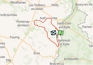
Tocht Stappen van 19,7 km beschikbaar op Normandië, Eure, Vexin-sur-Epte. Deze tocht wordt voorgesteld door philberard95.
Beschrijving
Berthenonville, Château sur Epte, Authevernes, Cahaignes, Requiécourt et Molincourt.
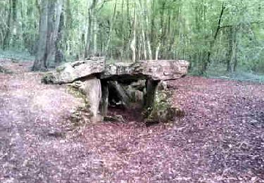
Allée couverte et Pierre tournante.
Plaatsbepaling
Land:
France
Regio :
Normandië
Departement/Provincie :
Eure
Gemeente :
Vexin-sur-Epte
Locatie:
Unknown
Vertrek:(Dec)
Vertrek:(UTM)
402338 ; 5448657 (31U) N.
Opmerkingen
Wandeltochten in de omgeving
![Tocht Stappen Château-sur-Epte - Château sur Epte - Berthenonville - Photo](https://media.geolcdn.com/t/375/260/ext.jpg?maxdim=2&url=https%3A%2F%2Fservices.sitytrail.com%2FGeolivesWS%2FDownloadMedia.ashx%3FTrailID%3D891370%26Media%3D28f306c4-ccd7-4e45-8d5f-378c794acdd1.jpg)
![Stappen Stappen](https://static1.geolcdn.com/sitytour/trail-icons/101.png)
Château sur Epte - Berthenonville
Stappen
Gemakkelijk
(1)
Château-sur-Epte,
Normandië,
Eure,
France
![](/images/other/stat-length.png)
7,8 km | 9,5 km-effort
2h 7min
![](https://static1.geolcdn.com/siteimages/upload/files/16400158638029165_repeat_loop_refresh_sync_direction_icon.png)
Ja
![Tocht Stappen Château-sur-Epte - Château sur Epte - Rollon Nord - Photo](https://media.geolcdn.com/t/375/260/ext.jpg?maxdim=2&url=https%3A%2F%2Fservices.sitytrail.com%2FGeolivesWS%2FDownloadMedia.ashx%3FTrailID%3D158414%26Media%3Df92478f2-a815-4319-b098-de4877cf6291.jpg)
![Stappen Stappen](https://static1.geolcdn.com/sitytour/trail-icons/101.png)
Château sur Epte - Rollon Nord
Stappen
Gemakkelijk
(1)
Château-sur-Epte,
Normandië,
Eure,
France
![](/images/other/stat-length.png)
8,4 km | 10,2 km-effort
2h 2min
![](https://static1.geolcdn.com/siteimages/upload/files/16400158638029165_repeat_loop_refresh_sync_direction_icon.png)
Ja
![Tocht Stappen Buhy - De Buchet à Magny en Vexin - Photo](https://media.geolcdn.com/t/375/260/1020b94f-166d-40ac-8266-f51a3f0e5d45.jpg&format=jpg&maxdim=2)
![Stappen Stappen](https://static1.geolcdn.com/sitytour/trail-icons/101.png)
De Buchet à Magny en Vexin
Stappen
Medium
Buhy,
Île-de-France,
Val-d'Oise,
France
![](/images/other/stat-length.png)
25 km | 29 km-effort
5h 3min
![](https://static1.geolcdn.com/siteimages/upload/files/16400158638029165_repeat_loop_refresh_sync_direction_icon.png)
Neen
![Tocht Stappen Vexin-sur-Epte - Château sur Epte variante par pierre tournante - Photo](https://media.geolcdn.com/t/375/260/ext.jpg?maxdim=2&url=https%3A%2F%2Fstatic1.geolcdn.com%2Fsiteimages%2Fupload%2Ffiles%2F1553511878bg_sport_marche.png)
![Stappen Stappen](https://static1.geolcdn.com/sitytour/trail-icons/101.png)
Château sur Epte variante par pierre tournante
Stappen
Gemakkelijk
(1)
Vexin-sur-Epte,
Normandië,
Eure,
France
![](/images/other/stat-length.png)
9,8 km | 12,1 km-effort
2h 30min
![](https://static1.geolcdn.com/siteimages/upload/files/16400158638029165_repeat_loop_refresh_sync_direction_icon.png)
Ja
![Tocht Noords wandelen Authevernes - MN 57 Authevernes - Photo](https://media.geolcdn.com/t/375/260/ext.jpg?maxdim=2&url=https%3A%2F%2Fstatic1.geolcdn.com%2Fsiteimages%2Fupload%2Ffiles%2F1545311037marcheuse_200dpi.jpg)
![Noords wandelen Noords wandelen](https://static1.geolcdn.com/sitytour/trail-icons/102.png)
MN 57 Authevernes
Noords wandelen
Gemakkelijk
(3)
Authevernes,
Normandië,
Eure,
France
![](/images/other/stat-length.png)
8,5 km | 10,1 km-effort
1h 30min
![](https://static1.geolcdn.com/siteimages/upload/files/16400158638029165_repeat_loop_refresh_sync_direction_icon.png)
Ja
![Tocht Stappen Vexin-sur-Epte - Rando Douce 1 - Ecos - Photo](https://media.geolcdn.com/t/375/260/ext.jpg?maxdim=2&url=https%3A%2F%2Fstatic1.geolcdn.com%2Fsiteimages%2Fupload%2Ffiles%2F1553511878bg_sport_marche.png)
![Stappen Stappen](https://static1.geolcdn.com/sitytour/trail-icons/101.png)
Rando Douce 1 - Ecos
Stappen
Gemakkelijk
(1)
Vexin-sur-Epte,
Normandië,
Eure,
France
![](/images/other/stat-length.png)
6,5 km | 7,6 km-effort
1h 28min
![](https://static1.geolcdn.com/siteimages/upload/files/16400158638029165_repeat_loop_refresh_sync_direction_icon.png)
Ja
![Tocht Stappen Vexin-sur-Epte - Ecos - les trois boucles court - Photo](https://media.geolcdn.com/t/375/260/ext.jpg?maxdim=2&url=https%3A%2F%2Fstatic1.geolcdn.com%2Fsiteimages%2Fupload%2Ffiles%2F1553511878bg_sport_marche.png)
![Stappen Stappen](https://static1.geolcdn.com/sitytour/trail-icons/101.png)
Ecos - les trois boucles court
Stappen
Gemakkelijk
(2)
Vexin-sur-Epte,
Normandië,
Eure,
France
![](/images/other/stat-length.png)
11,1 km | 13,1 km-effort
2h 51min
![](https://static1.geolcdn.com/siteimages/upload/files/16400158638029165_repeat_loop_refresh_sync_direction_icon.png)
Ja
![Tocht Stappen Guerny - Gisancourt - Notre Dame du Chêne - Photo](https://media.geolcdn.com/t/375/260/ext.jpg?maxdim=2&url=https%3A%2F%2Fstatic1.geolcdn.com%2Fsiteimages%2Fupload%2Ffiles%2F1553511878bg_sport_marche.png)
![Stappen Stappen](https://static1.geolcdn.com/sitytour/trail-icons/101.png)
Gisancourt - Notre Dame du Chêne
Stappen
Gemakkelijk
(2)
Guerny,
Normandië,
Eure,
France
![](/images/other/stat-length.png)
11,6 km | 13,9 km-effort
3h 2min
![](https://static1.geolcdn.com/siteimages/upload/files/16400158638029165_repeat_loop_refresh_sync_direction_icon.png)
Ja
![Tocht Stappen Omerville - omerville et alentours - Photo](https://media.geolcdn.com/t/375/260/ext.jpg?maxdim=2&url=https%3A%2F%2Fstatic1.geolcdn.com%2Fsiteimages%2Fupload%2Ffiles%2F1553511878bg_sport_marche.png)
![Stappen Stappen](https://static1.geolcdn.com/sitytour/trail-icons/101.png)
omerville et alentours
Stappen
Gemakkelijk
(3)
Omerville,
Île-de-France,
Val-d'Oise,
France
![](/images/other/stat-length.png)
12,7 km | 16 km-effort
3h 17min
![](https://static1.geolcdn.com/siteimages/upload/files/16400158638029165_repeat_loop_refresh_sync_direction_icon.png)
Ja