![](/images/other/stat-length.png)
![Tocht Te voet Fiumalbo - 20221227Escursione - Photo](https://media.geolcdn.com/t/1900/400/ext.pjpeg?maxdim=2&url=https%3A%2F%2Fstatic1.geolcdn.com%2Fsiteimages%2Fupload%2Ffiles%2F1545311037marcheuse_200dpi.jpg)
20221227Escursione
Maurizio Melandri
Gebruiker
![Lengte](/images/other/stat-length.png)
![Max. hoogte](https://static1.geolcdn.com/siteimages/upload/files/1508320355ic_sort_altitude_max_24dp.png)
![Positief hoogteverschil](https://static1.geolcdn.com/siteimages/upload/files/1508320355ic_sort_den_pos_24dp.png)
![Km-Effort](/images/other/stat-length.png)
![Min. hoogte](https://static1.geolcdn.com/siteimages/upload/files/1508320355ic_sort_altitude_min_24dp.png)
![Negatief hoogteverschil](https://static1.geolcdn.com/siteimages/upload/files/1508320355ic_sort_den_neg_24dp.png)
![Boucle](https://static1.geolcdn.com/siteimages/upload/files/16400158638029165_repeat_loop_refresh_sync_direction_icon.png)
![Te voet](https://static1.geolcdn.com/sitytour/trail-icons/100.png)
1h51
Moeilijkheid : Medium
![Scan deze QR-code om de tocht te openen in de SityTrail-applicatie](https://capi.geolives.com/qq0zvz2zws4bq2lad0pu/sitytour/trails/3494401/qr.png?size=200)
Gratisgps-wandelapplicatie
Over ons
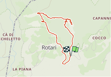
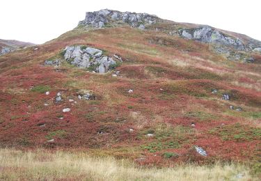
Tocht Te voet van 4,4 km beschikbaar op Emilia-Romagna, Modena, Fiumalbo. Deze tocht wordt voorgesteld door Maurizio Melandri.
Beschrijving
Si parte dal passo della Fiancata prendendo il sentiero CAI 509 e lo si segue fino alla cima del Monte Modino
Si discende usando il sentiero CAI 511a che ci porta fino al sentiero 511 con cui torneremo sulla strada che da Dogana Nuova va a Rotari.
L'ultima parte, su strada asfaltata, ci riporta al passo della Fiancata dove abbiamo lasciato la macchina
Plaatsbepaling
Opmerkingen
Wandeltochten in de omgeving
![Tocht Te voet Pievepelago - (SI L16) Lago Santo Modenese - Passo delle Radici - Photo](https://media.geolcdn.com/t/375/260/5e3e4a9c-3762-45fe-bacf-33e2f6ab55a3.jpeg&format=jpg&maxdim=2)
![Te voet Te voet](https://static1.geolcdn.com/sitytour/trail-icons/100.png)
Te voet
![](/images/other/stat-length.png)
![](https://static1.geolcdn.com/siteimages/upload/files/16400158638029165_repeat_loop_refresh_sync_direction_icon.png)
![Tocht Te voet Abetone Cutigliano - IT-507 - Photo](https://media.geolcdn.com/t/375/260/b0e1bc75-1c50-479c-ada2-a5db2babd61b.jpeg&format=jpg&maxdim=2)
![Te voet Te voet](https://static1.geolcdn.com/sitytour/trail-icons/100.png)
Te voet
![](/images/other/stat-length.png)
![](https://static1.geolcdn.com/siteimages/upload/files/16400158638029165_repeat_loop_refresh_sync_direction_icon.png)
![Tocht Te voet Pievepelago - (SI L16 OLD) Lago Santo Modenese - Passo delle Radici - Photo](https://media.geolcdn.com/t/375/260/5e3e4a9c-3762-45fe-bacf-33e2f6ab55a3.jpeg&format=jpg&maxdim=2)
![Te voet Te voet](https://static1.geolcdn.com/sitytour/trail-icons/100.png)
Te voet
![](/images/other/stat-length.png)
![](https://static1.geolcdn.com/siteimages/upload/files/16400158638029165_repeat_loop_refresh_sync_direction_icon.png)
![Tocht Te voet Abetone Cutigliano - (SI L15) Abetone (Boscolungo) - Lago Santo Modenese - Photo](https://media.geolcdn.com/t/375/260/d9c856e7-0fee-46cb-b1dc-d250ecd0b74b.jpeg&format=jpg&maxdim=2)
![Te voet Te voet](https://static1.geolcdn.com/sitytour/trail-icons/100.png)
Te voet
![](/images/other/stat-length.png)
![](https://static1.geolcdn.com/siteimages/upload/files/16400158638029165_repeat_loop_refresh_sync_direction_icon.png)
![Tocht Te voet Fiumalbo - IT-505 - Photo](https://media.geolcdn.com/t/375/260/ba8edcd9-6d4d-4a3d-9510-b543506f2742.jpeg&format=jpg&maxdim=2)
![Te voet Te voet](https://static1.geolcdn.com/sitytour/trail-icons/100.png)
Te voet
![](/images/other/stat-length.png)
![](https://static1.geolcdn.com/siteimages/upload/files/16400158638029165_repeat_loop_refresh_sync_direction_icon.png)
![Tocht Te voet Abetone Cutigliano - IT-100 - Photo](https://media.geolcdn.com/t/375/260/555a5dd0-53d5-431c-8b7e-814ca8ca46c4.jpeg&format=jpg&maxdim=2)
![Te voet Te voet](https://static1.geolcdn.com/sitytour/trail-icons/100.png)
Te voet
![](/images/other/stat-length.png)
![](https://static1.geolcdn.com/siteimages/upload/files/16400158638029165_repeat_loop_refresh_sync_direction_icon.png)
![Tocht Te voet Abetone Cutigliano - Sentiero del Tedesco - Photo](https://media.geolcdn.com/t/375/260/ab8c7a67-de8b-49bd-88d7-f633522fd8d7.jpeg&format=jpg&maxdim=2)
![Te voet Te voet](https://static1.geolcdn.com/sitytour/trail-icons/100.png)
Te voet
![](/images/other/stat-length.png)
![](https://static1.geolcdn.com/siteimages/upload/files/16400158638029165_repeat_loop_refresh_sync_direction_icon.png)
![Tocht Te voet Pievepelago - IT-539 - Photo](https://media.geolcdn.com/t/375/260/947fc455-3f41-4811-8c06-dd2b0fd54c00.jpeg&format=jpg&maxdim=2)
![Te voet Te voet](https://static1.geolcdn.com/sitytour/trail-icons/100.png)
Te voet
![](/images/other/stat-length.png)
![](https://static1.geolcdn.com/siteimages/upload/files/16400158638029165_repeat_loop_refresh_sync_direction_icon.png)
![Tocht Te voet Fiumalbo - IT-487 - Photo](https://media.geolcdn.com/t/375/260/c380166d-b449-4f0b-8f40-36ba415db876.jpeg&format=jpg&maxdim=2)
![Te voet Te voet](https://static1.geolcdn.com/sitytour/trail-icons/100.png)
Te voet
![](/images/other/stat-length.png)
![](https://static1.geolcdn.com/siteimages/upload/files/16400158638029165_repeat_loop_refresh_sync_direction_icon.png)