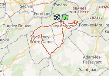
![](/images/other/stat-length.png)
![Tocht Stappen Silley-Bléfond - Silley Blėfond - Photo](https://media.geolcdn.com/t/1900/400/72cba853-944f-4e71-a6a4-e1015b10675c.jpg&format=pjpeg&maxdim=2)
Silley Blėfond
eltonnermou
Gebruiker
![Lengte](/images/other/stat-length.png)
![Max. hoogte](https://static1.geolcdn.com/siteimages/upload/files/1508320355ic_sort_altitude_max_24dp.png)
![Positief hoogteverschil](https://static1.geolcdn.com/siteimages/upload/files/1508320355ic_sort_den_pos_24dp.png)
![Km-Effort](/images/other/stat-length.png)
![Min. hoogte](https://static1.geolcdn.com/siteimages/upload/files/1508320355ic_sort_altitude_min_24dp.png)
![Negatief hoogteverschil](https://static1.geolcdn.com/siteimages/upload/files/1508320355ic_sort_den_neg_24dp.png)
![Boucle](https://static1.geolcdn.com/siteimages/upload/files/16400158638029165_repeat_loop_refresh_sync_direction_icon.png)
![Stappen](https://static1.geolcdn.com/sitytour/trail-icons/101.png)
3h23
Moeilijkheid : Medium
![Scan deze QR-code om de tocht te openen in de SityTrail-applicatie](https://capi.geolives.com/qq0zvz2zws4bq2lad0pu/sitytour/trails/3481109/qr.png?size=200)
Gratisgps-wandelapplicatie
Over ons
Tocht Stappen van 15,8 km beschikbaar op Bourgondië-Franche-Comté, Doubs, Silley-Bléfond. Deze tocht wordt voorgesteld door eltonnermou.
Beschrijving
parking mairie
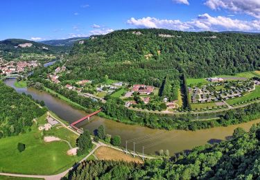
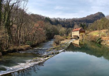
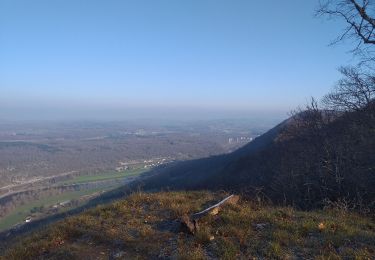
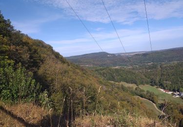
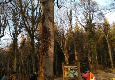
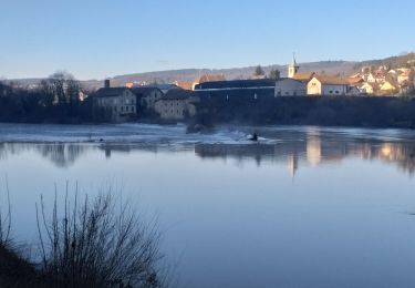
Belle randonnée avec de beaux points de vue sur la vallée du Doubs. Le cheminement est parfois difficile, les bâtons sont fortement conseillés.
Dans ces espaces escarpés laissez vous surprendre par la faune sauvage (chamois, chevreuil, ...). Petit bémol, un peu trop de goudron (et pas assez de plumes) à mon goût.
Plaatsbepaling
Opmerkingen
Wandeltochten in de omgeving
![Tocht Stappen Dammartin-les-Templiers - dammartin les templiers - Photo](https://media.geolcdn.com/t/375/260/c2bd0938-453f-48b0-b513-762bbdd613a3.jpg&format=jpg&maxdim=2)
![Stappen Stappen](https://static1.geolcdn.com/sitytour/trail-icons/101.png)
Stappen
![](/images/other/stat-length.png)
![](https://static1.geolcdn.com/siteimages/upload/files/16400158638029165_repeat_loop_refresh_sync_direction_icon.png)
![Tocht Te voet Bretigney-Notre-Dame - Les Gorges de l'Audeux - Photo](https://media.geolcdn.com/t/375/260/3c4f074e-3673-45a1-aa6d-0738dd54ea67.jpeg&format=jpg&maxdim=2)
![Te voet Te voet](https://static1.geolcdn.com/sitytour/trail-icons/100.png)
Te voet
![](/images/other/stat-length.png)
![](https://static1.geolcdn.com/siteimages/upload/files/16400158638029165_repeat_loop_refresh_sync_direction_icon.png)
![Tocht Te voet Esnans - Mont Dommage - Photo](https://media.geolcdn.com/t/375/260/79f418a8-7ee1-46f5-8173-ee740f887b5c.jpeg&format=jpg&maxdim=2)
![Te voet Te voet](https://static1.geolcdn.com/sitytour/trail-icons/100.png)
Te voet
![](/images/other/stat-length.png)
![](https://static1.geolcdn.com/siteimages/upload/files/16400158638029165_repeat_loop_refresh_sync_direction_icon.png)
![Tocht Te voet Baume-les-Dames - La Croix de Châtard - Photo](https://media.geolcdn.com/t/375/260/d651c9f5-c262-4fb0-99ee-1d55033f4dec.jpeg&format=jpg&maxdim=2)
![Te voet Te voet](https://static1.geolcdn.com/sitytour/trail-icons/100.png)
Te voet
![](/images/other/stat-length.png)
![](https://static1.geolcdn.com/siteimages/upload/files/16400158638029165_repeat_loop_refresh_sync_direction_icon.png)
![Tocht Te voet Baume-les-Dames - La Fente de Babre - Photo](https://media.geolcdn.com/t/375/260/f4606131-7993-4602-bc5e-c9844fe9a64f.jpeg&format=jpg&maxdim=2)
![Te voet Te voet](https://static1.geolcdn.com/sitytour/trail-icons/100.png)
Te voet
![](/images/other/stat-length.png)
![](https://static1.geolcdn.com/siteimages/upload/files/16400158638029165_repeat_loop_refresh_sync_direction_icon.png)
![Tocht Stappen Ougney-Douvot - ougney la Roche (douvot) - Photo](https://media.geolcdn.com/t/375/260/532e6234-3db8-43f6-834f-754785112099.jpg&format=jpg&maxdim=2)
![Stappen Stappen](https://static1.geolcdn.com/sitytour/trail-icons/101.png)
Stappen
![](/images/other/stat-length.png)
![](https://static1.geolcdn.com/siteimages/upload/files/16400158638029165_repeat_loop_refresh_sync_direction_icon.png)
![Tocht Stappen Pont-les-Moulins - pont les moulins - Photo](https://media.geolcdn.com/t/375/260/7e6122b6-1654-426d-8833-6b2b329e62b0.jpg&format=jpg&maxdim=2)
![Stappen Stappen](https://static1.geolcdn.com/sitytour/trail-icons/101.png)
Stappen
![](/images/other/stat-length.png)
![](https://static1.geolcdn.com/siteimages/upload/files/16400158638029165_repeat_loop_refresh_sync_direction_icon.png)
![Tocht Stappen Séchin - Sechin 23 janvier 2020 CAF - Photo](https://media.geolcdn.com/t/375/260/9bdc166d-03a0-478f-a63a-eb5267e40a66.jpg&format=jpg&maxdim=2)
![Stappen Stappen](https://static1.geolcdn.com/sitytour/trail-icons/101.png)
Stappen
![](/images/other/stat-length.png)
![](https://static1.geolcdn.com/siteimages/upload/files/16400158638029165_repeat_loop_refresh_sync_direction_icon.png)
![Tocht Stappen Baume-les-Dames - Baume les dames, fente de Babre - Photo](https://media.geolcdn.com/t/375/260/aa0af467-9313-4a29-a7b9-19f30e0259cd.jpg&format=jpg&maxdim=2)
![Stappen Stappen](https://static1.geolcdn.com/sitytour/trail-icons/101.png)
Stappen
![](/images/other/stat-length.png)
![](https://static1.geolcdn.com/siteimages/upload/files/16400158638029165_repeat_loop_refresh_sync_direction_icon.png)