![](/images/other/stat-length.png)
![Tocht Stappen Orgères - Orgères, circuit sud - Photo](https://media.geolcdn.com/t/1900/400/ext.pjpeg?maxdim=2&url=https%3A%2F%2Fstatic1.geolcdn.com%2Fsiteimages%2Fupload%2Ffiles%2F1553511878bg_sport_marche.png)
Orgères, circuit sud
chasle
Gebruiker
![Lengte](/images/other/stat-length.png)
![Max. hoogte](https://static1.geolcdn.com/siteimages/upload/files/1508320355ic_sort_altitude_max_24dp.png)
![Positief hoogteverschil](https://static1.geolcdn.com/siteimages/upload/files/1508320355ic_sort_den_pos_24dp.png)
![Km-Effort](/images/other/stat-length.png)
![Min. hoogte](https://static1.geolcdn.com/siteimages/upload/files/1508320355ic_sort_altitude_min_24dp.png)
![Negatief hoogteverschil](https://static1.geolcdn.com/siteimages/upload/files/1508320355ic_sort_den_neg_24dp.png)
![Boucle](https://static1.geolcdn.com/siteimages/upload/files/16400158638029165_repeat_loop_refresh_sync_direction_icon.png)
![Stappen](https://static1.geolcdn.com/sitytour/trail-icons/101.png)
4h17
Moeilijkheid : Gemakkelijk
![Scan deze QR-code om de tocht te openen in de SityTrail-applicatie](https://capi.geolives.com/qq0zvz2zws4bq2lad0pu/sitytour/trails/3465484/qr.png?size=200)
Gratisgps-wandelapplicatie
Over ons
Tocht Stappen van 16,4 km beschikbaar op Bretagne, Ille-et-Vilaine, Orgères. Deze tocht wordt voorgesteld door chasle.
Beschrijving
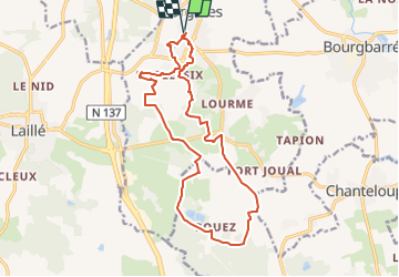
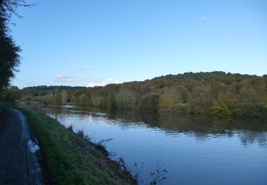
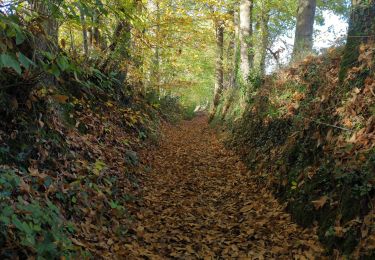
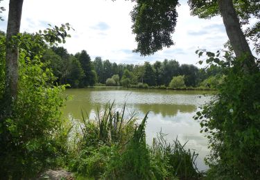
Au sud de l'agglomération rennaise, sur l'axe Rennes - Nantes, [b]Orgères[/b] est une commune offrant un cadre de vie à la fois urbain et rural. Son territoire avec de nombreuses zones boisées s'étend sur des espaces naturels et agricoles. Ce topo présente une boucle de randonnée sur le sud de la commune vers le bois de Pouez.
Départ du parking de la salle des Fêtes.
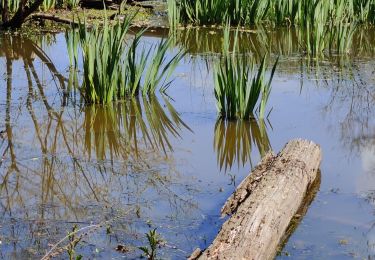
Partir vers la halle des sports et le plan d'eau de la Blanchetais au sud du lotissement. Prendre la passerelle au sud du plan d'eau, entre pavillons jusqu'à la rue de l'Hermitage. Prendre à gauche le [b]circuit du moulin de la Chicane[/b], vers l'ancien [b]Moulin des Quatre Vents[/b] et la Plessette. Suivre le balisage jusqu'au carrefour sur la D41 et prendre à droite la route de la Grée vers les landes d'Orgères. Suivre maintenant le balisage du [b]circuit la balade de Pouez[/b] vers le bois de Pouez et la Ville Orion. A la fin du chemin des deux communes, tourner à gauche vers la lande du Moulin Boitel pour rejoindre
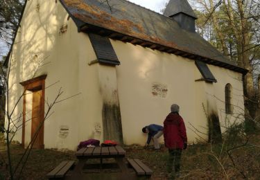
le ruisseau de la Blanchetais et la Lande des Deux Monts. Fin de parcours par le circuit du moulin de la chicane et le belvédère du centre ville près de l'église.
[b]Circuits d'Orgères[/b] : [url]https://www.visugpx.com/cUgFBYztXm[/url]
Plaatsbepaling
Opmerkingen
Wandeltochten in de omgeving
![Tocht Mountainbike Pont-Péan - Le long de la Vilaine - Pont Péan - Photo](https://media.geolcdn.com/t/375/260/ext.jpg?maxdim=2&url=https%3A%2F%2Fservices.sitytrail.com%2FGeolivesWS%2FDownloadMedia.ashx%3FTrailID%3D214889%26Media%3D15441_3.jpg)
![Mountainbike Mountainbike](https://static1.geolcdn.com/sitytour/trail-icons/202.png)
Mountainbike
![](/images/other/stat-length.png)
![](https://static1.geolcdn.com/siteimages/upload/files/16400158638029165_repeat_loop_refresh_sync_direction_icon.png)
![Tocht Stappen Pont-Péan - Randonnée autour de Pont-Péan - Photo](https://media.geolcdn.com/t/375/260/ext.jpg?maxdim=2&url=https%3A%2F%2Fservices.sitytrail.com%2FGeolivesWS%2FDownloadMedia.ashx%3FTrailID%3D191361%26Media%3D14926_3.jpg)
![Stappen Stappen](https://static1.geolcdn.com/sitytour/trail-icons/101.png)
Stappen
![](/images/other/stat-length.png)
![](https://static1.geolcdn.com/siteimages/upload/files/16400158638029165_repeat_loop_refresh_sync_direction_icon.png)
![Tocht Te voet Laillé - Laillé la Chapelle - Photo](https://media.geolcdn.com/t/375/260/80425336-5829-4a9b-bf94-af8dc6722242.jpeg&format=jpg&maxdim=2)
![Te voet Te voet](https://static1.geolcdn.com/sitytour/trail-icons/100.png)
Te voet
![](/images/other/stat-length.png)
![](https://static1.geolcdn.com/siteimages/upload/files/16400158638029165_repeat_loop_refresh_sync_direction_icon.png)
![Tocht Stappen Laillé - Laillé, Roche qui chome - Photo](https://media.geolcdn.com/t/375/260/420863b8-58d5-4ae8-816c-3f076cdd0c92.jpg&format=jpg&maxdim=2)
![Stappen Stappen](https://static1.geolcdn.com/sitytour/trail-icons/101.png)
Stappen
![](/images/other/stat-length.png)
![](https://static1.geolcdn.com/siteimages/upload/files/16400158638029165_repeat_loop_refresh_sync_direction_icon.png)
![Tocht Te voet Orgères - Circuit d'Orgerblon - Photo](https://media.geolcdn.com/t/375/260/8e6ed8ea-e08b-426d-a4df-886cc990daca.jpeg&format=jpg&maxdim=2)
![Te voet Te voet](https://static1.geolcdn.com/sitytour/trail-icons/100.png)
Te voet
![](/images/other/stat-length.png)
![](https://static1.geolcdn.com/siteimages/upload/files/16400158638029165_repeat_loop_refresh_sync_direction_icon.png)
![Tocht Te voet Orgères - Circuit des deux Monts et du Télégraphe - Photo](https://media.geolcdn.com/t/375/260/610afbfe-2a2c-4336-a051-18e768a6f818.jpeg&format=jpg&maxdim=2)
![Te voet Te voet](https://static1.geolcdn.com/sitytour/trail-icons/100.png)
Te voet
![](/images/other/stat-length.png)
![](https://static1.geolcdn.com/siteimages/upload/files/16400158638029165_repeat_loop_refresh_sync_direction_icon.png)
![Tocht Te voet Bourgbarré - Circuit de la Vayrie - Photo](https://media.geolcdn.com/t/375/260/ade5fc9d-0e6c-4531-86cd-cfdfad8d9910.jpeg&format=jpg&maxdim=2)
![Te voet Te voet](https://static1.geolcdn.com/sitytour/trail-icons/100.png)
Te voet
![](/images/other/stat-length.png)
![](https://static1.geolcdn.com/siteimages/upload/files/16400158638029165_repeat_loop_refresh_sync_direction_icon.png)
![Tocht Stappen Noyal-Châtillon-sur-Seiche - Noyal Châtillon 2 - Photo](https://media.geolcdn.com/t/375/260/b89e474f-43a3-432a-8a48-6a6c45a7502e.jpg&format=jpg&maxdim=2)
![Stappen Stappen](https://static1.geolcdn.com/sitytour/trail-icons/101.png)
Stappen
![](/images/other/stat-length.png)
![](https://static1.geolcdn.com/siteimages/upload/files/16400158638029165_repeat_loop_refresh_sync_direction_icon.png)
![Tocht Stappen Laillé - Laille, Chapelle du Désert - Photo](https://media.geolcdn.com/t/375/260/45ac716c-d87b-4273-81c1-8988ce8d629a.jpg&format=jpg&maxdim=2)
![Stappen Stappen](https://static1.geolcdn.com/sitytour/trail-icons/101.png)
Stappen
![](/images/other/stat-length.png)
![](https://static1.geolcdn.com/siteimages/upload/files/16400158638029165_repeat_loop_refresh_sync_direction_icon.png)