![](/images/other/stat-length.png)
![Tocht Paardrijden Saint-Cassien - 202211 boucle StCassien 15km - Photo](https://media.geolcdn.com/t/1900/400/ext.pjpeg?maxdim=2&url=https%3A%2F%2Fstatic1.geolcdn.com%2Fsiteimages%2Fupload%2Ffiles%2F1524743154cheval.jpg)
202211 boucle StCassien 15km
xhakon
Gebruiker
![Lengte](/images/other/stat-length.png)
Lengte
15,5 km
![Max. hoogte](https://static1.geolcdn.com/siteimages/upload/files/1508320355ic_sort_altitude_max_24dp.png)
Max. hoogte
484 m
![Positief hoogteverschil](https://static1.geolcdn.com/siteimages/upload/files/1508320355ic_sort_den_pos_24dp.png)
Positief hoogteverschil
317 m
![Km-Effort](/images/other/stat-length.png)
Km-Effort
19,7 km
![Min. hoogte](https://static1.geolcdn.com/siteimages/upload/files/1508320355ic_sort_altitude_min_24dp.png)
Min. hoogte
336 m
![Negatief hoogteverschil](https://static1.geolcdn.com/siteimages/upload/files/1508320355ic_sort_den_neg_24dp.png)
Negatief hoogteverschil
316 m
![Boucle](https://static1.geolcdn.com/siteimages/upload/files/16400158638029165_repeat_loop_refresh_sync_direction_icon.png)
Boucle
Ja
Datum van aanmaak :
2022-11-12 12:48:58.889
Laatste wijziging :
2022-11-13 19:33:08.056
![Paardrijden](https://static1.geolcdn.com/sitytour/trail-icons/301.png)
2h45
Moeilijkheid : Gemakkelijk
![Scan deze QR-code om de tocht te openen in de SityTrail-applicatie](https://capi.geolives.com/qq0zvz2zws4bq2lad0pu/sitytour/trails/3454719/qr.png?size=200)
Gratisgps-wandelapplicatie
Over ons
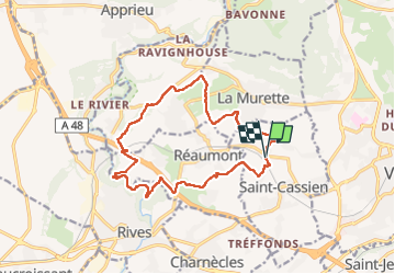
Tocht Paardrijden van 15,5 km beschikbaar op Auvergne-Rhône-Alpes, Isère, Saint-Cassien. Deze tocht wordt voorgesteld door xhakon.
Beschrijving
Boucle variée et roulante.
Ok pieds nus habitués avec quand-même pas mal de galets.
Organisée par Sophie G.
Plaatsbepaling
Land:
France
Regio :
Auvergne-Rhône-Alpes
Departement/Provincie :
Isère
Gemeente :
Saint-Cassien
Locatie:
Unknown
Vertrek:(Dec)
Vertrek:(UTM)
699394 ; 5026829 (31T) N.
Opmerkingen
Wandeltochten in de omgeving
![Tocht Mountainbike Chirens - Rives Vtt départ Chirens - Photo](https://media.geolcdn.com/t/375/260/ext.jpg?maxdim=2&url=https%3A%2F%2Fstatic1.geolcdn.com%2Fsiteimages%2Fupload%2Ffiles%2F1524743154velo.jpg)
![Mountainbike Mountainbike](https://static1.geolcdn.com/sitytour/trail-icons/202.png)
Rives Vtt départ Chirens
Mountainbike
Moeilijk
(1)
Chirens,
Auvergne-Rhône-Alpes,
Isère,
France
![](/images/other/stat-length.png)
25 km | 34 km-effort
2h 16min
![](https://static1.geolcdn.com/siteimages/upload/files/16400158638029165_repeat_loop_refresh_sync_direction_icon.png)
Neen
![Tocht Mountainbike Voiron - EVTT Merc.AM Charauze - Photo](https://media.geolcdn.com/t/375/260/ext.jpg?maxdim=2&url=https%3A%2F%2Fstatic1.geolcdn.com%2Fsiteimages%2Fupload%2Ffiles%2F1524743154velo.jpg)
![Mountainbike Mountainbike](https://static1.geolcdn.com/sitytour/trail-icons/202.png)
EVTT Merc.AM Charauze
Mountainbike
Gemakkelijk
(1)
Voiron,
Auvergne-Rhône-Alpes,
Isère,
France
![](/images/other/stat-length.png)
12,9 km | 16 km-effort
1h 6min
![](https://static1.geolcdn.com/siteimages/upload/files/16400158638029165_repeat_loop_refresh_sync_direction_icon.png)
Ja
![Tocht Stappen Saint-Blaise-du-Buis - Le tour des Voyes - Photo](https://media.geolcdn.com/t/375/260/52e090e6-02ac-4fdb-b326-05575f2c58a3.jpg&format=jpg&maxdim=2)
![Stappen Stappen](https://static1.geolcdn.com/sitytour/trail-icons/101.png)
Le tour des Voyes
Stappen
Gemakkelijk
Saint-Blaise-du-Buis,
Auvergne-Rhône-Alpes,
Isère,
France
![](/images/other/stat-length.png)
8,5 km | 10,6 km-effort
2h 24min
![](https://static1.geolcdn.com/siteimages/upload/files/16400158638029165_repeat_loop_refresh_sync_direction_icon.png)
Ja
![Tocht Stappen Réaumont - reaumont 2019 - Photo](https://media.geolcdn.com/t/375/260/5dec39a5-985b-46be-b425-20477c11c827.jpg&format=jpg&maxdim=2)
![Stappen Stappen](https://static1.geolcdn.com/sitytour/trail-icons/101.png)
reaumont 2019
Stappen
Gemakkelijk
Réaumont,
Auvergne-Rhône-Alpes,
Isère,
France
![](/images/other/stat-length.png)
8,2 km | 10,6 km-effort
2h 57min
![](https://static1.geolcdn.com/siteimages/upload/files/16400158638029165_repeat_loop_refresh_sync_direction_icon.png)
Ja
![Tocht Stappen La Murette - Pays Voironnais - Tour de la Murette - Photo](https://media.geolcdn.com/t/375/260/ext.jpg?maxdim=2&url=https%3A%2F%2Fservices.sitytrail.com%2FGeolivesWS%2FDownloadMedia.ashx%3FTrailID%3D109051%26Media%3D3060_1.jpg)
![Stappen Stappen](https://static1.geolcdn.com/sitytour/trail-icons/101.png)
Pays Voironnais - Tour de la Murette
Stappen
Gemakkelijk
(1)
La Murette,
Auvergne-Rhône-Alpes,
Isère,
France
![](/images/other/stat-length.png)
3,5 km | 4,4 km-effort
45min
![](https://static1.geolcdn.com/siteimages/upload/files/16400158638029165_repeat_loop_refresh_sync_direction_icon.png)
Ja
![Tocht Stappen Rives - Anniv Do - Photo](https://media.geolcdn.com/t/375/260/ext.jpg?maxdim=2&url=https%3A%2F%2Fstatic1.geolcdn.com%2Fsiteimages%2Fupload%2Ffiles%2F1553511878bg_sport_marche.png)
![Stappen Stappen](https://static1.geolcdn.com/sitytour/trail-icons/101.png)
Anniv Do
Stappen
Medium
Rives,
Auvergne-Rhône-Alpes,
Isère,
France
![](/images/other/stat-length.png)
7,8 km | 9,8 km-effort
2h 12min
![](https://static1.geolcdn.com/siteimages/upload/files/16400158638029165_repeat_loop_refresh_sync_direction_icon.png)
Ja
![Tocht Stappen Saint-Nicolas-de-Macherin - Étang des Chartreux et St Sixte depuis St Nicolas de M. - 01 mai 2022 - Photo](https://media.geolcdn.com/t/375/260/ext.jpg?maxdim=2&url=https%3A%2F%2Fstatic1.geolcdn.com%2Fsiteimages%2Fupload%2Ffiles%2F1553511878bg_sport_marche.png)
![Stappen Stappen](https://static1.geolcdn.com/sitytour/trail-icons/101.png)
Étang des Chartreux et St Sixte depuis St Nicolas de M. - 01 mai 2022
Stappen
Gemakkelijk
Saint-Nicolas-de-Macherin,
Auvergne-Rhône-Alpes,
Isère,
France
![](/images/other/stat-length.png)
15 km | 22 km-effort
4h 3min
![](https://static1.geolcdn.com/siteimages/upload/files/16400158638029165_repeat_loop_refresh_sync_direction_icon.png)
Ja
![Tocht Mountainbike La Murette - Chara - Photo](https://media.geolcdn.com/t/375/260/ext.jpg?maxdim=2&url=https%3A%2F%2Fstatic1.geolcdn.com%2Fsiteimages%2Fupload%2Ffiles%2F1524743154velo.jpg)
![Mountainbike Mountainbike](https://static1.geolcdn.com/sitytour/trail-icons/202.png)
Chara
Mountainbike
Moeilijk
La Murette,
Auvergne-Rhône-Alpes,
Isère,
France
![](/images/other/stat-length.png)
20 km | 26 km-effort
2h 26min
![](https://static1.geolcdn.com/siteimages/upload/files/16400158638029165_repeat_loop_refresh_sync_direction_icon.png)
Ja
![Tocht Stappen Rives - rando rives - Photo](https://media.geolcdn.com/t/375/260/ext.jpg?maxdim=2&url=https%3A%2F%2Fstatic1.geolcdn.com%2Fsiteimages%2Fupload%2Ffiles%2F1553511878bg_sport_marche.png)
![Stappen Stappen](https://static1.geolcdn.com/sitytour/trail-icons/101.png)
rando rives
Stappen
Heel gemakkelijk
Rives,
Auvergne-Rhône-Alpes,
Isère,
France
![](/images/other/stat-length.png)
6 km | 7,5 km-effort
2h 28min
![](https://static1.geolcdn.com/siteimages/upload/files/16400158638029165_repeat_loop_refresh_sync_direction_icon.png)
Ja