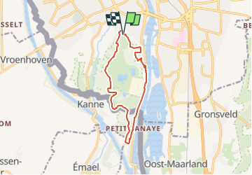
![](/images/other/stat-length.png)
![Tocht Stappen Maastricht - 2022-11-12_10h20m44_sint-pietersberg-en-enci-groeve-ma3-maastricht (1) - Photo](https://media.geolcdn.com/t/1900/400/ext.pjpeg?maxdim=2&url=https%3A%2F%2Fstatic1.geolcdn.com%2Fsiteimages%2Fupload%2Ffiles%2F1553511878bg_sport_marche.png)
2022-11-12_10h20m44_sint-pietersberg-en-enci-groeve-ma3-maastricht (1)
mumu.larandonneuse
Gebruiker GUIDE
![Lengte](/images/other/stat-length.png)
![Max. hoogte](https://static1.geolcdn.com/siteimages/upload/files/1508320355ic_sort_altitude_max_24dp.png)
![Positief hoogteverschil](https://static1.geolcdn.com/siteimages/upload/files/1508320355ic_sort_den_pos_24dp.png)
![Km-Effort](/images/other/stat-length.png)
![Min. hoogte](https://static1.geolcdn.com/siteimages/upload/files/1508320355ic_sort_altitude_min_24dp.png)
![Negatief hoogteverschil](https://static1.geolcdn.com/siteimages/upload/files/1508320355ic_sort_den_neg_24dp.png)
![Boucle](https://static1.geolcdn.com/siteimages/upload/files/16400158638029165_repeat_loop_refresh_sync_direction_icon.png)
![Stappen](https://static1.geolcdn.com/sitytour/trail-icons/101.png)
3h04
Moeilijkheid : Medium
![Scan deze QR-code om de tocht te openen in de SityTrail-applicatie](https://capi.geolives.com/qq0zvz2zws4bq2lad0pu/sitytour/trails/3454239/qr.png?size=200)
Gratisgps-wandelapplicatie
Over ons
Tocht Stappen van 10,8 km beschikbaar op Limburg, Onbekend, Maastricht. Deze tocht wordt voorgesteld door mumu.larandonneuse.
Beschrijving
ℹ www.visitzuidlimburg.nl
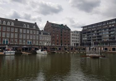
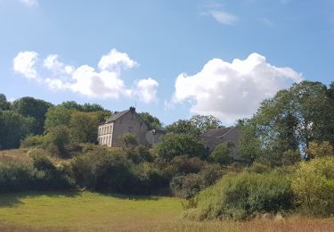
➡️ La périphérie de Maastricht vaut sans aucun doute une visite. Itinéraire est une longue marche à travers la région de Natuurmonumenten.
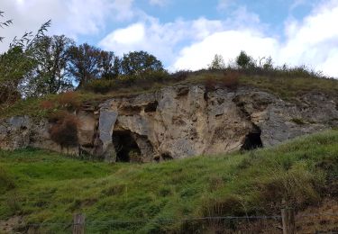
Vous vous promenez autour du Sint-Pietersberg ou vous découvrez le Fort Sint-Pieter (le trail ne passe pas par la carrière). Il est possible de faire la promenade avec le chien tenu en laisse. Vous pouvez vous promener dans la carrière sur la route jaune (plus courte), mais les chiens ne sont pas autorisés ici.
De plus, vous avez une belle vue sur la Meuse. La carrière ENCI est encore en plein développement : on y voit de l'activité, mais aussi de la belle nature. Un must absolu pour une promenade près de Maastricht.
Le parcours commence au Fort Saint-Pierre et vous pouvez garer votre voiture à l'Œil de Saint-Pierre. En chemin, vous croiserez divers établissements de restauration.
Le parcours fait environ 10,5 kilomètres. Le parcours est balisé par des poteaux avec un triangle rouge sur une plaque blanche. Une flèche bleue indique alors la direction.
Plaatsbepaling
Opmerkingen
Wandeltochten in de omgeving
![Tocht Stappen Eijsden-Margraten - 2024-01-08_03h28m34_eijsden-margraten-e8-bloesemroute-3 - Photo](https://media.geolcdn.com/t/375/260/7792b7db-95a9-4b53-8cd5-7eae3fedc6a4.jpg&format=jpg&maxdim=2)
![Stappen Stappen](https://static1.geolcdn.com/sitytour/trail-icons/101.png)
Stappen
![](/images/other/stat-length.png)
![](https://static1.geolcdn.com/siteimages/upload/files/16400158638029165_repeat_loop_refresh_sync_direction_icon.png)
![Tocht Stappen Riemst - 2023-08-16_09h58m46_1192.gpx.xml - Photo](https://media.geolcdn.com/t/375/260/63b86f10-f314-488d-80d4-00787e3a9126.jpg&format=jpg&maxdim=2)
![Stappen Stappen](https://static1.geolcdn.com/sitytour/trail-icons/101.png)
Stappen
![](/images/other/stat-length.png)
![](https://static1.geolcdn.com/siteimages/upload/files/16400158638029165_repeat_loop_refresh_sync_direction_icon.png)
![Tocht Stappen Maastricht - 2023-07-28_14h10m13_1693.gpx.xml - Photo](https://media.geolcdn.com/t/375/260/35d0d485-5909-42ec-b3f4-9d96e17c2c7d.jpg&format=jpg&maxdim=2)
![Stappen Stappen](https://static1.geolcdn.com/sitytour/trail-icons/101.png)
Stappen
![](/images/other/stat-length.png)
![](https://static1.geolcdn.com/siteimages/upload/files/16400158638029165_repeat_loop_refresh_sync_direction_icon.png)
![Tocht Stappen Eijsden-Margraten - 2022-11-10_16h33m33_1327 - Photo](https://media.geolcdn.com/t/375/260/877eed2d-204c-4212-a49e-caf4fc574b56.jpg&format=jpg&maxdim=2)
![Stappen Stappen](https://static1.geolcdn.com/sitytour/trail-icons/101.png)
Stappen
![](/images/other/stat-length.png)
![](https://static1.geolcdn.com/siteimages/upload/files/16400158638029165_repeat_loop_refresh_sync_direction_icon.png)
![Tocht Stappen Maastricht - Maastricht - Hoge Fronten & 't Bassin - Photo](https://media.geolcdn.com/t/375/260/0d1db1de-c9bf-433a-9df4-c07031a55999.jpg&format=jpg&maxdim=2)
![Stappen Stappen](https://static1.geolcdn.com/sitytour/trail-icons/101.png)
Stappen
![](/images/other/stat-length.png)
![](https://static1.geolcdn.com/siteimages/upload/files/16400158638029165_repeat_loop_refresh_sync_direction_icon.png)
![Tocht Stappen Maastricht - 2022-07-06_09h30m07_1540 - Photo](https://media.geolcdn.com/t/375/260/8e415027-26b4-4bc6-9623-75f03f38b59c.jpg&format=jpg&maxdim=2)
![Stappen Stappen](https://static1.geolcdn.com/sitytour/trail-icons/101.png)
Stappen
![](/images/other/stat-length.png)
![](https://static1.geolcdn.com/siteimages/upload/files/16400158638029165_repeat_loop_refresh_sync_direction_icon.png)
![Tocht Stappen Maastricht - 2022-06-10_16h16m23_1459 - Photo](https://media.geolcdn.com/t/375/260/bd8acbf6-ee38-4b48-89c0-97eec4bf77bd.jpg&format=jpg&maxdim=2)
![Stappen Stappen](https://static1.geolcdn.com/sitytour/trail-icons/101.png)
Stappen
![](/images/other/stat-length.png)
![](https://static1.geolcdn.com/siteimages/upload/files/16400158638029165_repeat_loop_refresh_sync_direction_icon.png)
![Tocht Stappen Maastricht - 2021-10-27_21h23m34_1087 - Photo](https://media.geolcdn.com/t/375/260/23f3cb69-ec7d-4156-85e2-e9b9420f412b.jpg&format=jpg&maxdim=2)
![Stappen Stappen](https://static1.geolcdn.com/sitytour/trail-icons/101.png)
Stappen
![](/images/other/stat-length.png)
![](https://static1.geolcdn.com/siteimages/upload/files/16400158638029165_repeat_loop_refresh_sync_direction_icon.png)
![Tocht Stappen Maastricht - 2021-07-30_08h24m01_280 - Photo](https://media.geolcdn.com/t/375/260/68c18dc9-dcb8-48e4-b64a-8d1fd453745f.jpg&format=jpg&maxdim=2)
![Stappen Stappen](https://static1.geolcdn.com/sitytour/trail-icons/101.png)
Stappen
![](/images/other/stat-length.png)
![](https://static1.geolcdn.com/siteimages/upload/files/16400158638029165_repeat_loop_refresh_sync_direction_icon.png)