![](/images/other/stat-length.png)
![Tocht Stappen Beekdaelen - 2022-11-11_18h13m14_panoramaroute-sc08-schinnen - Photo](https://media.geolcdn.com/t/1900/400/ext.pjpeg?maxdim=2&url=https%3A%2F%2Fstatic1.geolcdn.com%2Fsiteimages%2Fupload%2Ffiles%2F1553511878bg_sport_marche.png)
2022-11-11_18h13m14_panoramaroute-sc08-schinnen
mumu.larandonneuse
Gebruiker GUIDE
![Lengte](/images/other/stat-length.png)
![Max. hoogte](https://static1.geolcdn.com/siteimages/upload/files/1508320355ic_sort_altitude_max_24dp.png)
![Positief hoogteverschil](https://static1.geolcdn.com/siteimages/upload/files/1508320355ic_sort_den_pos_24dp.png)
![Km-Effort](/images/other/stat-length.png)
![Min. hoogte](https://static1.geolcdn.com/siteimages/upload/files/1508320355ic_sort_altitude_min_24dp.png)
![Negatief hoogteverschil](https://static1.geolcdn.com/siteimages/upload/files/1508320355ic_sort_den_neg_24dp.png)
![Boucle](https://static1.geolcdn.com/siteimages/upload/files/16400158638029165_repeat_loop_refresh_sync_direction_icon.png)
![Stappen](https://static1.geolcdn.com/sitytour/trail-icons/101.png)
3h54
Moeilijkheid : Medium
![Scan deze QR-code om de tocht te openen in de SityTrail-applicatie](https://capi.geolives.com/qq0zvz2zws4bq2lad0pu/sitytour/trails/3453733/qr.png?size=200)
Gratisgps-wandelapplicatie
Over ons
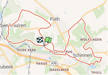
Tocht Stappen van 14,1 km beschikbaar op Limburg, Onbekend, Beekdaelen. Deze tocht wordt voorgesteld door mumu.larandonneuse.
Beschrijving
ℹ www.visitzuidlimburg.nl
➡️ Route panoramique SC08
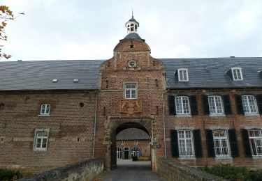
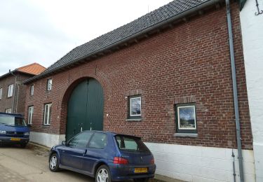
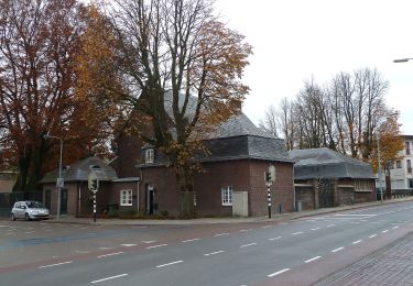
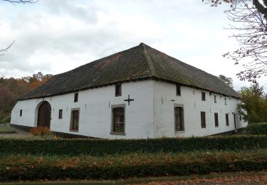
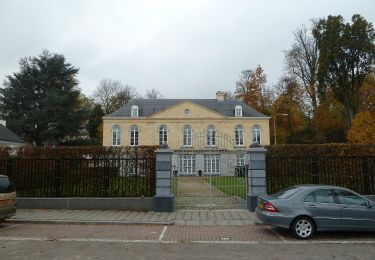
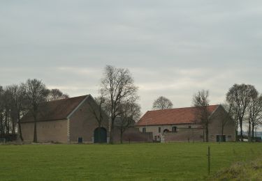
Qu'est-ce qui rend le Limbourg si amusant ? Est-ce les châteaux anciens, les authentiques maisons à colombages et les églises et chapelles qui respirent encore la culture catholique ? S'agit-il des forêts luxuriantes à flanc de colline, des prairies vallonnées et des ruisseaux qui ondulent dans les vallées ? Est-ce les bières spéciales, les plats bourguignons et la gentillesse des gens ? Vous les rencontrerez tous sur cet itinéraire de randonnée dans les magnifiques environs de Schinnen, afin que vous puissiez juger par vous-même de ce qui rend votre expérience du sud du Limbourg si inoubliable.Vous utiliserez également la route panoramique au château de Terborgh, où ils ont une excellente maison d'hôtes, et suivez les poteaux orange (anneau).
📍 Oliemolenweg , 6365 Schinnen, Pays-Bas.
Plaatsbepaling
Opmerkingen
Wandeltochten in de omgeving
![Tocht Te voet Beekdaelen - Schepenroute - Photo](https://media.geolcdn.com/t/375/260/3dc83ec1-eb05-4590-bc82-c92e8a8aa294.jpeg&format=jpg&maxdim=2)
![Te voet Te voet](https://static1.geolcdn.com/sitytour/trail-icons/100.png)
Te voet
![](/images/other/stat-length.png)
![](https://static1.geolcdn.com/siteimages/upload/files/16400158638029165_repeat_loop_refresh_sync_direction_icon.png)
![Tocht Te voet Beekdaelen - Dwergroute - Photo](https://media.geolcdn.com/t/375/260/48445299-af41-4ecb-86b3-522df3308e1f.jpeg&format=jpg&maxdim=2)
![Te voet Te voet](https://static1.geolcdn.com/sitytour/trail-icons/100.png)
Te voet
![](/images/other/stat-length.png)
![](https://static1.geolcdn.com/siteimages/upload/files/16400158638029165_repeat_loop_refresh_sync_direction_icon.png)
![Tocht Te voet Beekdaelen - Kroedwösjroute - Photo](https://media.geolcdn.com/t/375/260/b56d4c08-b24e-42eb-8416-1ce9bf72759e.jpeg&format=jpg&maxdim=2)
![Te voet Te voet](https://static1.geolcdn.com/sitytour/trail-icons/100.png)
Te voet
![](/images/other/stat-length.png)
![](https://static1.geolcdn.com/siteimages/upload/files/16400158638029165_repeat_loop_refresh_sync_direction_icon.png)
![Tocht Te voet Beekdaelen - Gröbberoute - Photo](https://media.geolcdn.com/t/375/260/b56d4c08-b24e-42eb-8416-1ce9bf72759e.jpeg&format=jpg&maxdim=2)
![Te voet Te voet](https://static1.geolcdn.com/sitytour/trail-icons/100.png)
Te voet
![](/images/other/stat-length.png)
![](https://static1.geolcdn.com/siteimages/upload/files/16400158638029165_repeat_loop_refresh_sync_direction_icon.png)
![Tocht Te voet Beekdaelen - Droepnaasroute - Photo](https://media.geolcdn.com/t/375/260/1a0117ec-7eca-4d8e-8dcf-4542aea011c8.jpeg&format=jpg&maxdim=2)
![Te voet Te voet](https://static1.geolcdn.com/sitytour/trail-icons/100.png)
Te voet
![](/images/other/stat-length.png)
![](https://static1.geolcdn.com/siteimages/upload/files/16400158638029165_repeat_loop_refresh_sync_direction_icon.png)
![Tocht Te voet Beekdaelen - Kollenboomroute - Photo](https://media.geolcdn.com/t/375/260/e12664f1-60f5-45cc-b950-31ef25be4e8a.jpeg&format=jpg&maxdim=2)
![Te voet Te voet](https://static1.geolcdn.com/sitytour/trail-icons/100.png)
Te voet
![](/images/other/stat-length.png)
![](https://static1.geolcdn.com/siteimages/upload/files/16400158638029165_repeat_loop_refresh_sync_direction_icon.png)
![Tocht Te voet Beekdaelen - Zevenmijlslaarzenroute - Photo](https://media.geolcdn.com/t/375/260/dev_1fdcc12b-c712-40a2-acfe-86dd1f2376f2.jpeg&format=jpg&maxdim=2)
![Te voet Te voet](https://static1.geolcdn.com/sitytour/trail-icons/100.png)
Te voet
![](/images/other/stat-length.png)
![](https://static1.geolcdn.com/siteimages/upload/files/16400158638029165_repeat_loop_refresh_sync_direction_icon.png)
![Tocht Te voet Beekdaelen - De route van de Reus - Photo](https://media.geolcdn.com/t/375/260/338816e8-9944-45a5-9788-662998f69101.jpeg&format=jpg&maxdim=2)
![Te voet Te voet](https://static1.geolcdn.com/sitytour/trail-icons/100.png)
Te voet
![](/images/other/stat-length.png)
![](https://static1.geolcdn.com/siteimages/upload/files/16400158638029165_repeat_loop_refresh_sync_direction_icon.png)
![Tocht Te voet Beek - Rondje Genhout - Photo](https://media.geolcdn.com/t/375/260/abb5d7e1-7a3a-42b7-bbd5-5c0d66587d99.jpeg&format=jpg&maxdim=2)
![Te voet Te voet](https://static1.geolcdn.com/sitytour/trail-icons/100.png)
Te voet
![](/images/other/stat-length.png)
![](https://static1.geolcdn.com/siteimages/upload/files/16400158638029165_repeat_loop_refresh_sync_direction_icon.png)