![](/images/other/stat-length.png)
Projet de voie verte Pourcieux Trets Rousset Fuveau Gardanne
ericberlin
Gebruiker
![Lengte](/images/other/stat-length.png)
![Max. hoogte](https://static1.geolcdn.com/siteimages/upload/files/1508320355ic_sort_altitude_max_24dp.png)
![Positief hoogteverschil](https://static1.geolcdn.com/siteimages/upload/files/1508320355ic_sort_den_pos_24dp.png)
![Km-Effort](/images/other/stat-length.png)
![Min. hoogte](https://static1.geolcdn.com/siteimages/upload/files/1508320355ic_sort_altitude_min_24dp.png)
![Negatief hoogteverschil](https://static1.geolcdn.com/siteimages/upload/files/1508320355ic_sort_den_neg_24dp.png)
![Boucle](https://static1.geolcdn.com/siteimages/upload/files/16400158638029165_repeat_loop_refresh_sync_direction_icon.png)
![Stappen](https://static1.geolcdn.com/sitytour/trail-icons/101.png)
7h00
Moeilijkheid : Gemakkelijk
![Noords wandelen](https://static1.geolcdn.com/sitytour/trail-icons/102.png)
0m
Moeilijkheid : Heel gemakkelijk
![Lopen](https://static1.geolcdn.com/sitytour/trail-icons/103.png)
0m
Moeilijkheid : Gemakkelijk
![Fiets](https://static1.geolcdn.com/sitytour/trail-icons/200.png)
1h30
Moeilijkheid : Gemakkelijk
![Fietstoerisme](https://static1.geolcdn.com/sitytour/trail-icons/204.png)
0m
Moeilijkheid : Heel gemakkelijk
![Elektrische fiets](https://static1.geolcdn.com/sitytour/trail-icons/205.png)
0m
Moeilijkheid : Heel gemakkelijk
![Varia](https://static1.geolcdn.com/sitytour/trail-icons/900.png)
0m
Moeilijkheid : Heel gemakkelijk
![Scan deze QR-code om de tocht te openen in de SityTrail-applicatie](https://capi.geolives.com/qq0zvz2zws4bq2lad0pu/sitytour/trails/3449669/qr.png?size=200)
Gratisgps-wandelapplicatie
Over ons
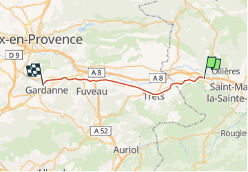
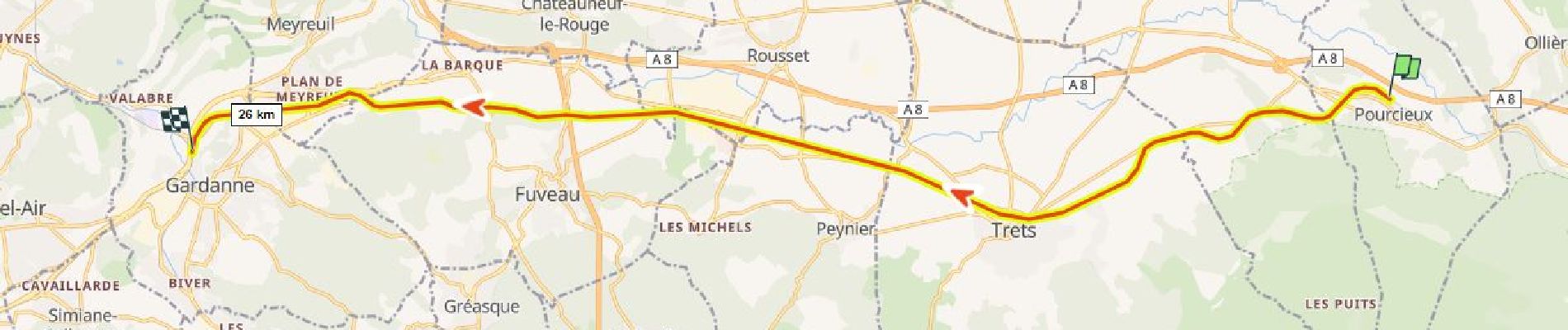
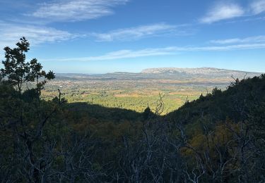
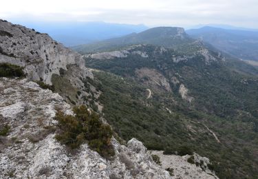
Tocht Stappen van 28 km beschikbaar op Provence-Alpes-Côte d'Azur, Var, Pourcieux. Deze tocht wordt voorgesteld door ericberlin.
Beschrijving
ATTENTION ceci n'est qu'un projet d’aménagement, il n’existe pas encore !
Projet de voie verte Pourcieux Trets Peynier Rousset Fuveau Gardanne en aménageant la voie ferrée désaffectée Gardanne-Carnoules.
Celle-ci étant désormais abandonnée par la SNCF.
Quoi de mieux qu’une voie ferrée pour créer une voie verte. Pas d’expropriations requises, tous les ponts existent déjà, tracé plat !
Ce projet mettrait en sécurité les usagers pour le travail et les loisirs :
Il dessert les zones d'activités de Trets, Rousset-Peynier-Fuveau, Meyreuil et Gardanne.
Il favorise le cyclotourisme dans la vallée de l'Arc.
Si vous êtes intéressé(e) postez ici votre avis et commentaire sur ce projet ou envoyer moi un message :
eric.berlin.f@gmail.com
Ressources utiles :
https://fr.wikipedia.org/
Voie_verte
Lignes_ferroviaires_françaises_désaffectées_ou_disparues (liste)
Ligne_de_Carnoules_à_Gardanne (historique)
Ligne_d’Aubagne_à_La_Barque (ramification à partir de Fuveau, petite portion déjà transformée en voie verte)
https://www.af3v.org/
https://www.ma-voie-verte.fr/
https://www.pistes-cyclables.com/
Plaatsbepaling
Opmerkingen
Wandeltochten in de omgeving
![Tocht Stappen Pourrières - JPS Monts Aurélien-17655561 - Photo](https://media.geolcdn.com/t/375/260/8dbb5ea6-c181-4e2b-88a9-6319fd5fd375.jpg&format=jpg&maxdim=2)
![Stappen Stappen](https://static1.geolcdn.com/sitytour/trail-icons/101.png)
Stappen
![](/images/other/stat-length.png)
![](https://static1.geolcdn.com/siteimages/upload/files/16400158638029165_repeat_loop_refresh_sync_direction_icon.png)
![Tocht Stappen Pourcieux - 2022-11-11_17h53m46_pourcieux - Photo](https://media.geolcdn.com/t/375/260/ext.jpg?maxdim=2&url=https%3A%2F%2Fstatic1.geolcdn.com%2Fsiteimages%2Fupload%2Ffiles%2F1553511878bg_sport_marche.png)
![Stappen Stappen](https://static1.geolcdn.com/sitytour/trail-icons/101.png)
Stappen
![](/images/other/stat-length.png)
![](https://static1.geolcdn.com/siteimages/upload/files/16400158638029165_repeat_loop_refresh_sync_direction_icon.png)
![Tocht Stappen Pourcieux - pas des iifs - Photo](https://media.geolcdn.com/t/375/260/ext.jpg?maxdim=2&url=https%3A%2F%2Fstatic1.geolcdn.com%2Fsiteimages%2Fupload%2Ffiles%2F1553511878bg_sport_marche.png)
![Stappen Stappen](https://static1.geolcdn.com/sitytour/trail-icons/101.png)
Stappen
![](/images/other/stat-length.png)
![](https://static1.geolcdn.com/siteimages/upload/files/16400158638029165_repeat_loop_refresh_sync_direction_icon.png)
![Tocht Stappen Pourrières - Mt Olympe et le pas du Titet - Photo](https://media.geolcdn.com/t/375/260/dc918a12-1c27-4a5f-a427-bc8e0fdbc469.jpg&format=jpg&maxdim=2)
![Stappen Stappen](https://static1.geolcdn.com/sitytour/trail-icons/101.png)
Stappen
![](/images/other/stat-length.png)
![](https://static1.geolcdn.com/siteimages/upload/files/16400158638029165_repeat_loop_refresh_sync_direction_icon.png)
![Tocht Stappen Pourcieux - 2024-03-02_17h01m33_La chouette d'Or Pourcieux - Photo](https://media.geolcdn.com/t/375/260/ext.jpg?maxdim=2&url=https%3A%2F%2Fstatic1.geolcdn.com%2Fsiteimages%2Fupload%2Ffiles%2F1553511878bg_sport_marche.png)
![Stappen Stappen](https://static1.geolcdn.com/sitytour/trail-icons/101.png)
Stappen
![](/images/other/stat-length.png)
![](https://static1.geolcdn.com/siteimages/upload/files/16400158638029165_repeat_loop_refresh_sync_direction_icon.png)
![Tocht Stappen Trets - SityTrail - mont olympe + crête - Photo](https://media.geolcdn.com/t/375/260/ext.jpg?maxdim=2&url=https%3A%2F%2Fstatic1.geolcdn.com%2Fsiteimages%2Fupload%2Ffiles%2F1553511878bg_sport_marche.png)
![Stappen Stappen](https://static1.geolcdn.com/sitytour/trail-icons/101.png)
Stappen
![](/images/other/stat-length.png)
![](https://static1.geolcdn.com/siteimages/upload/files/16400158638029165_repeat_loop_refresh_sync_direction_icon.png)
![Tocht Stappen Pourrières - Pourcieux :Mont Olympe et Pas du Titet - Photo](https://media.geolcdn.com/t/375/260/bc3de33d-3e9b-495a-a14b-a8c68a4f3699.jpg&format=jpg&maxdim=2)
![Stappen Stappen](https://static1.geolcdn.com/sitytour/trail-icons/101.png)
Stappen
![](/images/other/stat-length.png)
![](https://static1.geolcdn.com/siteimages/upload/files/16400158638029165_repeat_loop_refresh_sync_direction_icon.png)
![Stappen Stappen](https://static1.geolcdn.com/sitytour/trail-icons/101.png)
Stappen
![](/images/other/stat-length.png)
![](https://static1.geolcdn.com/siteimages/upload/files/16400158638029165_repeat_loop_refresh_sync_direction_icon.png)
![Tocht Stappen Pourcieux - Croix de pourcieux - Photo](https://media.geolcdn.com/t/375/260/028bd40e-26d3-4985-87d9-e7ed90ef1201.jpg&format=jpg&maxdim=2)
![Stappen Stappen](https://static1.geolcdn.com/sitytour/trail-icons/101.png)
Stappen
![](/images/other/stat-length.png)
![](https://static1.geolcdn.com/siteimages/upload/files/16400158638029165_repeat_loop_refresh_sync_direction_icon.png)