![](/images/other/stat-length.png)
Cinque Terre, Monterosso, Vernazza, Corniglia, Manarola, Riomaggiore
ericberlin
Gebruiker
![Lengte](/images/other/stat-length.png)
Lengte
22 km
![Max. hoogte](https://static1.geolcdn.com/siteimages/upload/files/1508320355ic_sort_altitude_max_24dp.png)
Max. hoogte
536 m
![Positief hoogteverschil](https://static1.geolcdn.com/siteimages/upload/files/1508320355ic_sort_den_pos_24dp.png)
Positief hoogteverschil
1501 m
![Km-Effort](/images/other/stat-length.png)
Km-Effort
42 km
![Min. hoogte](https://static1.geolcdn.com/siteimages/upload/files/1508320355ic_sort_altitude_min_24dp.png)
Min. hoogte
-6 m
![Negatief hoogteverschil](https://static1.geolcdn.com/siteimages/upload/files/1508320355ic_sort_den_neg_24dp.png)
Negatief hoogteverschil
1457 m
![Boucle](https://static1.geolcdn.com/siteimages/upload/files/16400158638029165_repeat_loop_refresh_sync_direction_icon.png)
Boucle
Neen
Datum van aanmaak :
2022-10-30 08:20:41.266
Laatste wijziging :
2023-06-05 15:55:26.695
![Stappen](https://static1.geolcdn.com/sitytour/trail-icons/101.png)
9h33
Moeilijkheid : Zeer moeilijk
![Scan deze QR-code om de tocht te openen in de SityTrail-applicatie](https://capi.geolives.com/qq0zvz2zws4bq2lad0pu/sitytour/trails/3440335/qr.png?size=200)
Gratisgps-wandelapplicatie
Over ons
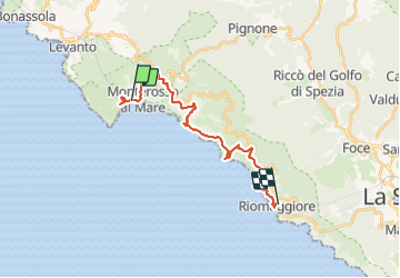
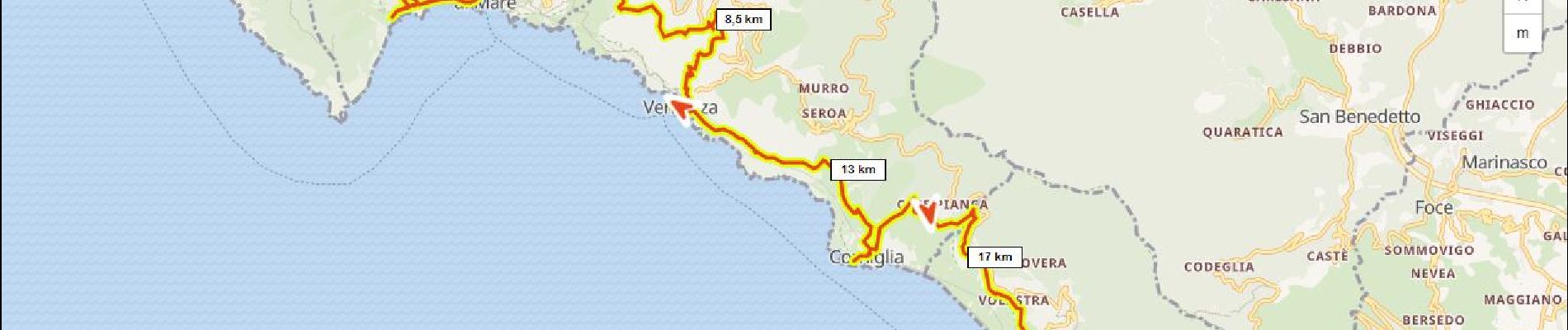
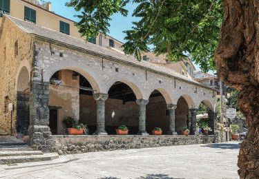
Tocht Stappen van 22 km beschikbaar op Ligurië, La Spezia, Monterosso al Mare. Deze tocht wordt voorgesteld door ericberlin.
Beschrijving
Projet de tracé pour plusieurs jours
Sources:
https://hiking.waymarkedtrails.org/
https://www.i-trekkings.net/
https://www.baladescotieres.com
http://www.parconazionale5terre.it/
https://www.cailaspezia.it/
Plaatsbepaling
Land:
Italy
Regio :
Ligurië
Departement/Provincie :
La Spezia
Gemeente :
Monterosso al Mare
Locatie:
Unknown
Vertrek:(Dec)
Vertrek:(UTM)
551905 ; 4888280 (32T) N.
Opmerkingen
Wandeltochten in de omgeving
![Tocht Stappen Vernazza - Rando cinq Terre 4ème jour Vernazza-Riomaggiore - Photo](https://media.geolcdn.com/t/375/260/f9331efa-b16c-4633-8239-c8a50683b624.jpg&format=jpg&maxdim=2)
![Stappen Stappen](https://static1.geolcdn.com/sitytour/trail-icons/101.png)
Rando cinq Terre 4ème jour Vernazza-Riomaggiore
Stappen
Zeer moeilijk
(1)
Vernazza,
Ligurië,
La Spezia,
Italy
![](/images/other/stat-length.png)
12,4 km | 23 km-effort
4h 26min
![](https://static1.geolcdn.com/siteimages/upload/files/16400158638029165_repeat_loop_refresh_sync_direction_icon.png)
Neen
![Tocht Stappen Vernazza - Fernacchi - manarola - Photo](https://media.geolcdn.com/t/375/260/ext.jpg?maxdim=2&url=https%3A%2F%2Fstatic1.geolcdn.com%2Fsiteimages%2Fupload%2Ffiles%2F1553511878bg_sport_marche.png)
![Stappen Stappen](https://static1.geolcdn.com/sitytour/trail-icons/101.png)
Fernacchi - manarola
Stappen
Gemakkelijk
(1)
Vernazza,
Ligurië,
La Spezia,
Italy
![](/images/other/stat-length.png)
5,8 km | 9,7 km-effort
2h 12min
![](https://static1.geolcdn.com/siteimages/upload/files/16400158638029165_repeat_loop_refresh_sync_direction_icon.png)
Neen
![Tocht Stappen Levanto - Levanto - Vernazza 6.5.23 - Photo](https://media.geolcdn.com/t/375/260/0287dcd3-7795-4c8b-8f35-962c00e797c3.jpg&format=jpg&maxdim=2)
![Stappen Stappen](https://static1.geolcdn.com/sitytour/trail-icons/101.png)
Levanto - Vernazza 6.5.23
Stappen
Moeilijk
Levanto,
Ligurië,
La Spezia,
Italy
![](/images/other/stat-length.png)
14,1 km | 23 km-effort
5h 0min
![](https://static1.geolcdn.com/siteimages/upload/files/16400158638029165_repeat_loop_refresh_sync_direction_icon.png)
Neen
![Tocht Te voet Levanto - Vallesanta - Monte delle Streghe - Colletto - Photo](https://media.geolcdn.com/t/375/260/efa63fd2-8e4e-4cf6-bbf2-2f4e4541a575.jpeg&format=jpg&maxdim=2)
![Te voet Te voet](https://static1.geolcdn.com/sitytour/trail-icons/100.png)
Vallesanta - Monte delle Streghe - Colletto
Te voet
Gemakkelijk
Levanto,
Ligurië,
La Spezia,
Italy
![](/images/other/stat-length.png)
4,6 km | 9,5 km-effort
2h 9min
![](https://static1.geolcdn.com/siteimages/upload/files/16400158638029165_repeat_loop_refresh_sync_direction_icon.png)
Neen
![Tocht Te voet Levanto - Il Termine – Mad.di Soviore – Colla di Gritta – S.Antonio al Mesco - Photo](https://media.geolcdn.com/t/375/260/7d93da1b-0b41-4fef-acc9-26fc84562262.jpeg&format=jpg&maxdim=2)
![Te voet Te voet](https://static1.geolcdn.com/sitytour/trail-icons/100.png)
Il Termine – Mad.di Soviore – Colla di Gritta – S.Antonio al Mesco
Te voet
Gemakkelijk
Levanto,
Ligurië,
La Spezia,
Italy
![](/images/other/stat-length.png)
7,4 km | 12,6 km-effort
2h 52min
![](https://static1.geolcdn.com/siteimages/upload/files/16400158638029165_repeat_loop_refresh_sync_direction_icon.png)
Neen
![Tocht Te voet Levanto - Levanto - Montale - Foce di Montale - Valle Carbonetta - Photo](https://media.geolcdn.com/t/375/260/f14c232d-65b5-4ec2-b169-eb236882792a.jpeg&format=jpg&maxdim=2)
![Te voet Te voet](https://static1.geolcdn.com/sitytour/trail-icons/100.png)
Levanto - Montale - Foce di Montale - Valle Carbonetta
Te voet
Gemakkelijk
Levanto,
Ligurië,
La Spezia,
Italy
![](/images/other/stat-length.png)
6,3 km | 11,5 km-effort
2h 37min
![](https://static1.geolcdn.com/siteimages/upload/files/16400158638029165_repeat_loop_refresh_sync_direction_icon.png)
Neen
![Tocht Te voet Levanto - Tuvo – C.sa Massola – M.Focone - innesto 591 - Photo](https://media.geolcdn.com/t/375/260/ad9ed57f-9477-4e43-95c5-11010ee7449f.jpeg&format=jpg&maxdim=2)
![Te voet Te voet](https://static1.geolcdn.com/sitytour/trail-icons/100.png)
Tuvo – C.sa Massola – M.Focone - innesto 591
Te voet
Gemakkelijk
Levanto,
Ligurië,
La Spezia,
Italy
![](/images/other/stat-length.png)
3,4 km | 7,2 km-effort
1h 38min
![](https://static1.geolcdn.com/siteimages/upload/files/16400158638029165_repeat_loop_refresh_sync_direction_icon.png)
Neen
![Tocht Te voet Levanto - Pian di Barca – Mad. del Trezzo – Pignone - M. Martinasca – M. Crocettola - Photo](https://media.geolcdn.com/t/375/260/7d93da1b-0b41-4fef-acc9-26fc84562262.jpeg&format=jpg&maxdim=2)
![Te voet Te voet](https://static1.geolcdn.com/sitytour/trail-icons/100.png)
Pian di Barca – Mad. del Trezzo – Pignone - M. Martinasca – M. Crocettola
Te voet
Gemakkelijk
Levanto,
Ligurië,
La Spezia,
Italy
![](/images/other/stat-length.png)
3,7 km | 5,8 km-effort
1h 19min
![](https://static1.geolcdn.com/siteimages/upload/files/16400158638029165_repeat_loop_refresh_sync_direction_icon.png)
Neen
![Tocht Te voet Levanto - Pié di Fontona – Fontona - Colla di Gritta - Photo](https://media.geolcdn.com/t/375/260/f14c232d-65b5-4ec2-b169-eb236882792a.jpeg&format=jpg&maxdim=2)
![Te voet Te voet](https://static1.geolcdn.com/sitytour/trail-icons/100.png)
Pié di Fontona – Fontona - Colla di Gritta
Te voet
Gemakkelijk
Levanto,
Ligurië,
La Spezia,
Italy
![](/images/other/stat-length.png)
4 km | 7,3 km-effort
1h 39min
![](https://static1.geolcdn.com/siteimages/upload/files/16400158638029165_repeat_loop_refresh_sync_direction_icon.png)
Neen