![](/images/other/stat-length.png)
![Tocht Stappen Steinbach - SityTrail - Steinbach-Thann - Photo](https://media.geolcdn.com/t/1900/400/ext.pjpeg?maxdim=2&url=https%3A%2F%2Fstatic1.geolcdn.com%2Fsiteimages%2Fupload%2Ffiles%2F1553511878bg_sport_marche.png)
SityTrail - Steinbach-Thann
E.BURCK
Gebruiker
![Lengte](/images/other/stat-length.png)
![Max. hoogte](https://static1.geolcdn.com/siteimages/upload/files/1508320355ic_sort_altitude_max_24dp.png)
![Positief hoogteverschil](https://static1.geolcdn.com/siteimages/upload/files/1508320355ic_sort_den_pos_24dp.png)
![Km-Effort](/images/other/stat-length.png)
![Min. hoogte](https://static1.geolcdn.com/siteimages/upload/files/1508320355ic_sort_altitude_min_24dp.png)
![Negatief hoogteverschil](https://static1.geolcdn.com/siteimages/upload/files/1508320355ic_sort_den_neg_24dp.png)
![Boucle](https://static1.geolcdn.com/siteimages/upload/files/16400158638029165_repeat_loop_refresh_sync_direction_icon.png)
![Stappen](https://static1.geolcdn.com/sitytour/trail-icons/101.png)
4h03
Moeilijkheid : Medium
![Scan deze QR-code om de tocht te openen in de SityTrail-applicatie](https://capi.geolives.com/qq0zvz2zws4bq2lad0pu/sitytour/trails/3435946/qr.png?size=200)
Gratisgps-wandelapplicatie
Over ons
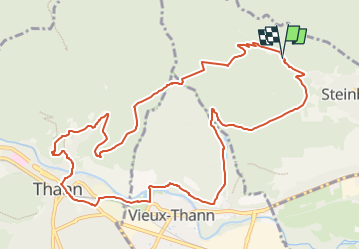
Tocht Stappen van 12,4 km beschikbaar op Grand Est, Haut-Rhin, Steinbach. Deze tocht wordt voorgesteld door E.BURCK.
Beschrijving
Pour manger au Moschenross à Thann en partant de Steinbach.
Dénivelé de 400 m, dont environ 100 m l'après midi, sur une distance totale de 12 km .
ACCÈS :
- Par Cernay, Steinbach puis direction Mine Saint Nicolas.
PARKING :
- sur la droite à la sortie de Steinbach avant d'arriver à la mine St Nicolas.
47.8251, 7.14114 ou
N 47°49'30", E 07°08'28"
DEPART : 9h30
RESTAURATION : Le Moschenross à Thann.
Tél.: 03 89 37 00 86
Plaatsbepaling
Opmerkingen
Wandeltochten in de omgeving
![Tocht Stappen Soultz-Haut-Rhin - Hartmannswillerkopf - Circuit découverte - Photo](https://media.geolcdn.com/t/375/260/ext.jpg?maxdim=2&url=https%3A%2F%2Fservices.sitytrail.com%2FGeolivesWS%2FDownloadMedia.ashx%3FTrailID%3D422294%26Media%3Dfix__20150517124954.jpg)
![Stappen Stappen](https://static1.geolcdn.com/sitytour/trail-icons/101.png)
Stappen
![](/images/other/stat-length.png)
![](https://static1.geolcdn.com/siteimages/upload/files/16400158638029165_repeat_loop_refresh_sync_direction_icon.png)
![Tocht Stappen Soultz-Haut-Rhin - Hartmannswillerkopf - Circuit anneau bleu - Photo](https://media.geolcdn.com/t/375/260/ext.jpg?maxdim=2&url=https%3A%2F%2Fservices.sitytrail.com%2FGeolivesWS%2FDownloadMedia.ashx%3FTrailID%3D422291%26Media%3Dfix__20150517150228.jpg)
![Stappen Stappen](https://static1.geolcdn.com/sitytour/trail-icons/101.png)
Stappen
![](/images/other/stat-length.png)
![](https://static1.geolcdn.com/siteimages/upload/files/16400158638029165_repeat_loop_refresh_sync_direction_icon.png)
![Tocht Andere activiteiten Steinbach - lac du ballon - Photo](https://media.geolcdn.com/t/375/260/ext.jpg?maxdim=2&url=https%3A%2F%2Fservices.sitytrail.com%2FGeolivesWS%2FDownloadMedia.ashx%3FTrailID%3D210434%26Media%3Dfix__20130805111422.jpg)
![Andere activiteiten Andere activiteiten](https://static1.geolcdn.com/sitytour/trail-icons/900.png)
Andere activiteiten
![](/images/other/stat-length.png)
![](https://static1.geolcdn.com/siteimages/upload/files/16400158638029165_repeat_loop_refresh_sync_direction_icon.png)
![Tocht Stappen Steinbach - Cascade de Erzenbach - Photo](https://media.geolcdn.com/t/375/260/069cb34c-c699-4fdf-8c9c-4524251a300c.jpg&format=jpg&maxdim=2)
![Stappen Stappen](https://static1.geolcdn.com/sitytour/trail-icons/101.png)
Stappen
![](/images/other/stat-length.png)
![](https://static1.geolcdn.com/siteimages/upload/files/16400158638029165_repeat_loop_refresh_sync_direction_icon.png)
![Tocht Wegfiets Cernay - Le Grand ballon de Cernay - Photo](https://media.geolcdn.com/t/375/260/8eb85347-6368-4eeb-8b65-86ddce4529dc.jpg&format=jpg&maxdim=2)
![Wegfiets Wegfiets](https://static1.geolcdn.com/sitytour/trail-icons/201.png)
Wegfiets
![](/images/other/stat-length.png)
![](https://static1.geolcdn.com/siteimages/upload/files/16400158638029165_repeat_loop_refresh_sync_direction_icon.png)
![Tocht Trail Wattwiller - The History Ultra - stage 1 - Photo](https://media.geolcdn.com/t/375/260/ext.jpg?maxdim=2&url=https%3A%2F%2Fstatic1.geolcdn.com%2Fsiteimages%2Fupload%2Ffiles%2F1524743154running.jpg)
![Trail Trail](https://static1.geolcdn.com/sitytour/trail-icons/104.png)
Trail
![](/images/other/stat-length.png)
![](https://static1.geolcdn.com/siteimages/upload/files/16400158638029165_repeat_loop_refresh_sync_direction_icon.png)
![Tocht Stappen Thann - SityTrail - 2489713 - thann-roche--albert--grumbachkopf - Photo](https://media.geolcdn.com/t/375/260/ext.jpg?maxdim=2&url=https%3A%2F%2Fstatic1.geolcdn.com%2Fsiteimages%2Fupload%2Ffiles%2F1553511878bg_sport_marche.png)
![Stappen Stappen](https://static1.geolcdn.com/sitytour/trail-icons/101.png)
Stappen
![](/images/other/stat-length.png)
![](https://static1.geolcdn.com/siteimages/upload/files/16400158638029165_repeat_loop_refresh_sync_direction_icon.png)
![Tocht Te voet Bitschwiller-lès-Thann - Bitschwiller les Thann - Rehbrunnel - Abri du Becherkopf - Roche Albert - Photo](https://media.geolcdn.com/t/375/260/ext.jpg?maxdim=2&url=https%3A%2F%2Fstatic1.geolcdn.com%2Fsiteimages%2Fupload%2Ffiles%2F1545311037marcheuse_200dpi.jpg)
![Te voet Te voet](https://static1.geolcdn.com/sitytour/trail-icons/100.png)
Te voet
![](/images/other/stat-length.png)
![](https://static1.geolcdn.com/siteimages/upload/files/16400158638029165_repeat_loop_refresh_sync_direction_icon.png)
![Tocht Stappen Uffholtz - Molkenrain 1 - Photo](https://media.geolcdn.com/t/375/260/ext.jpg?maxdim=2&url=https%3A%2F%2Fstatic1.geolcdn.com%2Fsiteimages%2Fupload%2Ffiles%2F1553511878bg_sport_marche.png)
![Stappen Stappen](https://static1.geolcdn.com/sitytour/trail-icons/101.png)
Stappen
![](/images/other/stat-length.png)
![](https://static1.geolcdn.com/siteimages/upload/files/16400158638029165_repeat_loop_refresh_sync_direction_icon.png)