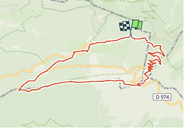
![](/images/other/stat-length.png)
![Tocht Stappen Beaumont-du-Ventoux - Ventoux-Rochers de Cachillan 12km - Photo](https://media.geolcdn.com/t/1900/400/f89fc7c6-5e21-403a-bfed-6357946e3a1d.jpg&format=pjpeg&maxdim=2)
Ventoux-Rochers de Cachillan 12km
thonyc
Gebruiker GUIDE
![Lengte](/images/other/stat-length.png)
![Max. hoogte](https://static1.geolcdn.com/siteimages/upload/files/1508320355ic_sort_altitude_max_24dp.png)
![Positief hoogteverschil](https://static1.geolcdn.com/siteimages/upload/files/1508320355ic_sort_den_pos_24dp.png)
![Km-Effort](/images/other/stat-length.png)
![Min. hoogte](https://static1.geolcdn.com/siteimages/upload/files/1508320355ic_sort_altitude_min_24dp.png)
![Negatief hoogteverschil](https://static1.geolcdn.com/siteimages/upload/files/1508320355ic_sort_den_neg_24dp.png)
![Boucle](https://static1.geolcdn.com/siteimages/upload/files/16400158638029165_repeat_loop_refresh_sync_direction_icon.png)
![Stappen](https://static1.geolcdn.com/sitytour/trail-icons/101.png)
5h30
Moeilijkheid : Zeer moeilijk
![Scan deze QR-code om de tocht te openen in de SityTrail-applicatie](https://capi.geolives.com/qq0zvz2zws4bq2lad0pu/sitytour/trails/3433118/qr.png?size=200)
Gratisgps-wandelapplicatie
Over ons
Tocht Stappen van 12,4 km beschikbaar op Provence-Alpes-Côte d'Azur, Vaucluse, Beaumont-du-Ventoux. Deze tocht wordt voorgesteld door thonyc.
Beschrijving
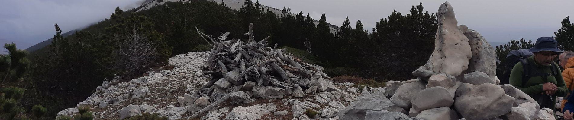
ATTENTION: rando très sportive avec une montée abrupte. Le passage sur les rochers de Cachillan est réservé à des randonneurs très expérimentés . En effet les lapiaz et pierriers rendent la progression difficile et scabreuse. Ne pas emmener d'enfants ou des personnes n'ayant pas un bon équilibre.
Plaatsbepaling
Opmerkingen
Wandeltochten in de omgeving
![Tocht Stappen Beaumont-du-Ventoux - Le Ventoux - Corniche Nord - Photo](https://media.geolcdn.com/t/375/260/ext.jpg?maxdim=2&url=https%3A%2F%2Fservices.sitytrail.com%2FGeolivesWS%2FDownloadMedia.ashx%3FTrailID%3D105329%26Media%3D9023_2.jpg)
![Stappen Stappen](https://static1.geolcdn.com/sitytour/trail-icons/101.png)
Stappen
![](/images/other/stat-length.png)
![](https://static1.geolcdn.com/siteimages/upload/files/16400158638029165_repeat_loop_refresh_sync_direction_icon.png)
![Tocht Stappen Beaumont-du-Ventoux - Sentier de découverte au Mont Serein - Photo](https://media.geolcdn.com/t/375/260/ext.jpg?maxdim=2&url=https%3A%2F%2Fservices.sitytrail.com%2FGeolivesWS%2FDownloadMedia.ashx%3FTrailID%3D103767%26Media%3D6520_2.jpg)
![Stappen Stappen](https://static1.geolcdn.com/sitytour/trail-icons/101.png)
Stappen
![](/images/other/stat-length.png)
![](https://static1.geolcdn.com/siteimages/upload/files/16400158638029165_repeat_loop_refresh_sync_direction_icon.png)
![Tocht Mountainbike Bédoin - Enduro Lilou Collet de Robin - Photo](https://media.geolcdn.com/t/375/260/5b277d16-82be-4683-8302-c0071eeba31c.jpg&format=jpg&maxdim=2)
![Mountainbike Mountainbike](https://static1.geolcdn.com/sitytour/trail-icons/202.png)
Mountainbike
![](/images/other/stat-length.png)
![](https://static1.geolcdn.com/siteimages/upload/files/16400158638029165_repeat_loop_refresh_sync_direction_icon.png)
![Tocht Mountainbike Bédoin - Enduro les Pins Noirs - Photo](https://media.geolcdn.com/t/375/260/2664f93b-d28f-4f7e-87bb-83b490384099.jpg&format=jpg&maxdim=2)
![Mountainbike Mountainbike](https://static1.geolcdn.com/sitytour/trail-icons/202.png)
Mountainbike
![](/images/other/stat-length.png)
![](https://static1.geolcdn.com/siteimages/upload/files/16400158638029165_repeat_loop_refresh_sync_direction_icon.png)
![Tocht Mountainbike Bédoin - Enduro ventoux Jas de Roubin - Photo](https://media.geolcdn.com/t/375/260/1373ca7b-671b-4daf-87c8-1e173f3e01d8.jpg&format=jpg&maxdim=2)
![Mountainbike Mountainbike](https://static1.geolcdn.com/sitytour/trail-icons/202.png)
Mountainbike
![](/images/other/stat-length.png)
![](https://static1.geolcdn.com/siteimages/upload/files/16400158638029165_repeat_loop_refresh_sync_direction_icon.png)
![Tocht Stappen Bédoin - Les Glacières du Facteur - Photo](https://media.geolcdn.com/t/375/260/cb31eb20-4ac1-469f-8550-b7fec6b9125d.jpg&format=jpg&maxdim=2)
![Stappen Stappen](https://static1.geolcdn.com/sitytour/trail-icons/101.png)
Stappen
![](/images/other/stat-length.png)
![](https://static1.geolcdn.com/siteimages/upload/files/16400158638029165_repeat_loop_refresh_sync_direction_icon.png)
![Tocht Stappen Bédoin - sentier du Vertige - Photo](https://media.geolcdn.com/t/375/260/537c0036-295e-4148-b1ac-658565f4196a.jpg&format=jpg&maxdim=2)
![Stappen Stappen](https://static1.geolcdn.com/sitytour/trail-icons/101.png)
Stappen
![](/images/other/stat-length.png)
![](https://static1.geolcdn.com/siteimages/upload/files/16400158638029165_repeat_loop_refresh_sync_direction_icon.png)
![Tocht Stappen Beaumont-du-Ventoux - Crêtes du Ventoux - Photo](https://media.geolcdn.com/t/375/260/91441923-a9c0-4765-9dda-d1eb9e281d5f.jpg&format=jpg&maxdim=2)
![Stappen Stappen](https://static1.geolcdn.com/sitytour/trail-icons/101.png)
Stappen
![](/images/other/stat-length.png)
![](https://static1.geolcdn.com/siteimages/upload/files/16400158638029165_repeat_loop_refresh_sync_direction_icon.png)
![Tocht Stappen Brantes - Ascencion du Ventoux sur 2 jours j1 - Photo](https://media.geolcdn.com/t/375/260/f9d58ab5-05c4-42e7-b010-c69a5ea3f997.jpg&format=jpg&maxdim=2)
![Stappen Stappen](https://static1.geolcdn.com/sitytour/trail-icons/101.png)
Stappen
![](/images/other/stat-length.png)
![](https://static1.geolcdn.com/siteimages/upload/files/16400158638029165_repeat_loop_refresh_sync_direction_icon.png)