![](/images/other/stat-length.png)
![Tocht Stappen Annot - Grès d'Annot Carte IGN 3541OT - Photo](https://media.geolcdn.com/t/1900/400/9f9453a3-f8fb-41f4-87f9-67579e26dbf0.jpg&format=pjpeg&maxdim=2)
Grès d'Annot Carte IGN 3541OT
domi06
Gebruiker
![Lengte](/images/other/stat-length.png)
![Max. hoogte](https://static1.geolcdn.com/siteimages/upload/files/1508320355ic_sort_altitude_max_24dp.png)
![Positief hoogteverschil](https://static1.geolcdn.com/siteimages/upload/files/1508320355ic_sort_den_pos_24dp.png)
![Km-Effort](/images/other/stat-length.png)
![Min. hoogte](https://static1.geolcdn.com/siteimages/upload/files/1508320355ic_sort_altitude_min_24dp.png)
![Negatief hoogteverschil](https://static1.geolcdn.com/siteimages/upload/files/1508320355ic_sort_den_neg_24dp.png)
![Boucle](https://static1.geolcdn.com/siteimages/upload/files/16400158638029165_repeat_loop_refresh_sync_direction_icon.png)
![Stappen](https://static1.geolcdn.com/sitytour/trail-icons/101.png)
7h23
Moeilijkheid : Medium
![Scan deze QR-code om de tocht te openen in de SityTrail-applicatie](https://capi.geolives.com/qq0zvz2zws4bq2lad0pu/sitytour/trails/3429896/qr.png?size=200)
Gratisgps-wandelapplicatie
Over ons
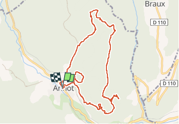
Tocht Stappen van 11,3 km beschikbaar op Provence-Alpes-Côte d'Azur, Alpes-de-Haute-Provence, Annot. Deze tocht wordt voorgesteld door domi06.
Beschrijving
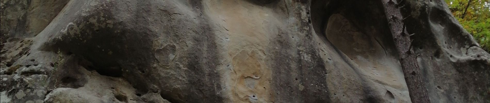
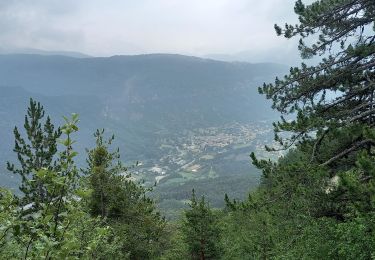
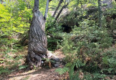
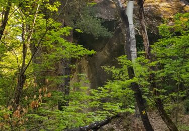
Au départ du village, le parcours monte dans une belle forêt de châtaigniers au milieu d'énormes blocs de grès. Il traverse ensuite l'étroit défilé des Garambes , le Jardin et la Chambre du Roi. Après un passage sur une corniche large mais vertigineuse on atteint un belvédère sur un large plateau gréseux donnant sur le vallon du Coulomp. Ensuite on franchit un joli plateau boisé jusqu'à l'arche rocheuse des Portettes avant de traverser une très belle forêt de châtaigniers centenaires pour arriver au sommet de ce parcours avant de redescendre sur Annot à travers des paysages forestiers typiques. Profitez pour visiter le village et sa belle église
Cotation E4/T3/R4
Plaatsbepaling
Opmerkingen
Wandeltochten in de omgeving
![Tocht Te voet Annot - Le Grès d'Annot - Photo](https://media.geolcdn.com/t/375/260/d494c9f4-04f5-4184-be97-f5fea23e1191.jpeg&format=jpg&maxdim=2)
![Te voet Te voet](https://static1.geolcdn.com/sitytour/trail-icons/100.png)
Te voet
![](/images/other/stat-length.png)
![](https://static1.geolcdn.com/siteimages/upload/files/16400158638029165_repeat_loop_refresh_sync_direction_icon.png)
![Tocht Stappen Annot - J4 Annot - Photo](https://media.geolcdn.com/t/375/260/be9d9d12-b8a6-45a8-bd70-6f8cacf32730.jpg&format=jpg&maxdim=2)
![Stappen Stappen](https://static1.geolcdn.com/sitytour/trail-icons/101.png)
Stappen
![](/images/other/stat-length.png)
![](https://static1.geolcdn.com/siteimages/upload/files/16400158638029165_repeat_loop_refresh_sync_direction_icon.png)
![Stappen Stappen](https://static1.geolcdn.com/sitytour/trail-icons/101.png)
Stappen
![](/images/other/stat-length.png)
![](https://static1.geolcdn.com/siteimages/upload/files/16400158638029165_repeat_loop_refresh_sync_direction_icon.png)
![Tocht Stappen Annot - Rando gastro Roncharel - Photo](https://media.geolcdn.com/t/375/260/4e3f8487-9887-4ec3-94b2-d5bbd50aefe8.jpg&format=jpg&maxdim=2)
![Stappen Stappen](https://static1.geolcdn.com/sitytour/trail-icons/101.png)
Stappen
![](/images/other/stat-length.png)
![](https://static1.geolcdn.com/siteimages/upload/files/16400158638029165_repeat_loop_refresh_sync_direction_icon.png)
![Tocht Stappen Annot - Les grès d'Annot - Photo](https://media.geolcdn.com/t/375/260/ext.jpg?maxdim=2&url=https%3A%2F%2Fstatic1.geolcdn.com%2Fsiteimages%2Fupload%2Ffiles%2F1553511878bg_sport_marche.png)
![Stappen Stappen](https://static1.geolcdn.com/sitytour/trail-icons/101.png)
Stappen
![](/images/other/stat-length.png)
![](https://static1.geolcdn.com/siteimages/upload/files/16400158638029165_repeat_loop_refresh_sync_direction_icon.png)
![Tocht Stappen Annot - Rando bleue - Photo](https://media.geolcdn.com/t/375/260/94ab7e9b-3b20-4840-b15c-d5a4c12ad390.jpg&format=jpg&maxdim=2)
![Stappen Stappen](https://static1.geolcdn.com/sitytour/trail-icons/101.png)
Stappen
![](/images/other/stat-length.png)
![](https://static1.geolcdn.com/siteimages/upload/files/16400158638029165_repeat_loop_refresh_sync_direction_icon.png)
![Tocht Stappen Braux - Rando Pieŕre qui tremble Chabrieres Peloussis Argenton - Photo](https://media.geolcdn.com/t/375/260/cfc0cc00-9a69-459b-9e00-f152d8d54736.jpg&format=jpg&maxdim=2)
![Stappen Stappen](https://static1.geolcdn.com/sitytour/trail-icons/101.png)
Stappen
![](/images/other/stat-length.png)
![](https://static1.geolcdn.com/siteimages/upload/files/16400158638029165_repeat_loop_refresh_sync_direction_icon.png)
![Tocht Stappen Annot - Les grès d'Annot-20-05-22 - Photo](https://media.geolcdn.com/t/375/260/3872c580-3dd5-4977-8057-6ad4a77228f8.jpg&format=jpg&maxdim=2)
![Stappen Stappen](https://static1.geolcdn.com/sitytour/trail-icons/101.png)
Stappen
![](/images/other/stat-length.png)
![](https://static1.geolcdn.com/siteimages/upload/files/16400158638029165_repeat_loop_refresh_sync_direction_icon.png)
![Tocht Stappen Annot - LES GRÈS D'ANNOT - Photo](https://media.geolcdn.com/t/375/260/8378a4cb-00ce-46f7-aa61-d9a6ee4d8606.jpg&format=jpg&maxdim=2)
![Stappen Stappen](https://static1.geolcdn.com/sitytour/trail-icons/101.png)
Stappen
![](/images/other/stat-length.png)
![](https://static1.geolcdn.com/siteimages/upload/files/16400158638029165_repeat_loop_refresh_sync_direction_icon.png)