![](/images/other/stat-length.png)
![Tocht Stappen Saint-Jean-Pied-de-Port - CAMINO FRANCES - Photo](https://media.geolcdn.com/t/1900/400/ext.pjpeg?maxdim=2&url=https%3A%2F%2Fstatic1.geolcdn.com%2Fsiteimages%2Fupload%2Ffiles%2F1553511878bg_sport_marche.png)
CAMINO FRANCES
patrickdanilo
Gebruiker
![Lengte](/images/other/stat-length.png)
Lengte
767 km
![Max. hoogte](https://static1.geolcdn.com/siteimages/upload/files/1508320355ic_sort_altitude_max_24dp.png)
Max. hoogte
1512 m
![Positief hoogteverschil](https://static1.geolcdn.com/siteimages/upload/files/1508320355ic_sort_den_pos_24dp.png)
Positief hoogteverschil
13600 m
![Km-Effort](/images/other/stat-length.png)
Km-Effort
948 km
![Min. hoogte](https://static1.geolcdn.com/siteimages/upload/files/1508320355ic_sort_altitude_min_24dp.png)
Min. hoogte
170 m
![Negatief hoogteverschil](https://static1.geolcdn.com/siteimages/upload/files/1508320355ic_sort_den_neg_24dp.png)
Negatief hoogteverschil
13509 m
![Boucle](https://static1.geolcdn.com/siteimages/upload/files/16400158638029165_repeat_loop_refresh_sync_direction_icon.png)
Boucle
Neen
Datum van aanmaak :
2022-10-17 08:00:25.969
Laatste wijziging :
2023-08-12 19:56:21.29
![Stappen](https://static1.geolcdn.com/sitytour/trail-icons/101.png)
215h33
Moeilijkheid : Zeer moeilijk
![Scan deze QR-code om de tocht te openen in de SityTrail-applicatie](https://capi.geolives.com/qq0zvz2zws4bq2lad0pu/sitytour/trails/3426451/qr.png?size=200)
Gratisgps-wandelapplicatie
Over ons
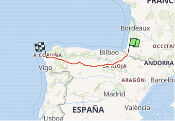
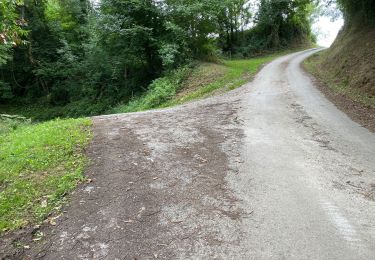
Tocht Stappen van 767 km beschikbaar op Nieuw-Aquitanië, Pyrénées-Atlantiques, Saint-Jean-Pied-de-Port. Deze tocht wordt voorgesteld door patrickdanilo.
Beschrijving
de Saint Jean Pied de Port à Saint Jacques de Compostelle.
Etapes et hébergements :
[url]https://www.gronze.com/camino-frances[/url]
Plaatsbepaling
Land:
France
Regio :
Nieuw-Aquitanië
Departement/Provincie :
Pyrénées-Atlantiques
Gemeente :
Saint-Jean-Pied-de-Port
Locatie:
Unknown
Vertrek:(Dec)
Vertrek:(UTM)
643309 ; 4780372 (30T) N.
Opmerkingen
Wandeltochten in de omgeving
![Tocht Stappen Saint-Jean-Pied-de-Port - C3.2 St Jean - Roncevaux - Photo](https://media.geolcdn.com/t/375/260/ext.jpg?maxdim=2&url=https%3A%2F%2Fservices.sitytrail.com%2FGeolivesWS%2FDownloadMedia.ashx%3FTrailID%3D202964%26Media%3Df4f6583b-22a3-4bf3-b263-f7ca0aca1565.jpg)
![Stappen Stappen](https://static1.geolcdn.com/sitytour/trail-icons/101.png)
C3.2 St Jean - Roncevaux
Stappen
Moeilijk
(1)
Saint-Jean-Pied-de-Port,
Nieuw-Aquitanië,
Pyrénées-Atlantiques,
France
![](/images/other/stat-length.png)
25 km | 41 km-effort
8h 56min
![](https://static1.geolcdn.com/siteimages/upload/files/16400158638029165_repeat_loop_refresh_sync_direction_icon.png)
Neen
![Tocht Stappen Ispoure - arradoy G4Fait - Photo](https://media.geolcdn.com/t/375/260/b1d4f481-6895-478c-81f3-6ef884c4075d.jpg&format=jpg&maxdim=2)
![Stappen Stappen](https://static1.geolcdn.com/sitytour/trail-icons/101.png)
arradoy G4Fait
Stappen
Heel gemakkelijk
Ispoure,
Nieuw-Aquitanië,
Pyrénées-Atlantiques,
France
![](/images/other/stat-length.png)
6 km | 9,7 km-effort
4h 14min
![](https://static1.geolcdn.com/siteimages/upload/files/16400158638029165_repeat_loop_refresh_sync_direction_icon.png)
Ja
![Tocht Noords wandelen Çaro - Col d'Irey ou Tour du pic d'Iramendy - Photo](https://media.geolcdn.com/t/375/260/ext.jpg?maxdim=2&url=https%3A%2F%2Fstatic1.geolcdn.com%2Fsiteimages%2Fupload%2Ffiles%2F1545311037marcheuse_200dpi.jpg)
![Noords wandelen Noords wandelen](https://static1.geolcdn.com/sitytour/trail-icons/102.png)
Col d'Irey ou Tour du pic d'Iramendy
Noords wandelen
Medium
(2)
Çaro,
Nieuw-Aquitanië,
Pyrénées-Atlantiques,
France
![](/images/other/stat-length.png)
24 km | 35 km-effort
6h 43min
![](https://static1.geolcdn.com/siteimages/upload/files/16400158638029165_repeat_loop_refresh_sync_direction_icon.png)
Ja
![Tocht Stappen Ispoure - Arradoy - Photo](https://media.geolcdn.com/t/375/260/ext.jpg?maxdim=2&url=https%3A%2F%2Fstatic1.geolcdn.com%2Fsiteimages%2Fupload%2Ffiles%2F1553511878bg_sport_marche.png)
![Stappen Stappen](https://static1.geolcdn.com/sitytour/trail-icons/101.png)
Arradoy
Stappen
Gemakkelijk
(2)
Ispoure,
Nieuw-Aquitanië,
Pyrénées-Atlantiques,
France
![](/images/other/stat-length.png)
6 km | 9,6 km-effort
2h 2min
![](https://static1.geolcdn.com/siteimages/upload/files/16400158638029165_repeat_loop_refresh_sync_direction_icon.png)
Ja
![Tocht Stappen Saint-Jean-Pied-de-Port - 2023 10 14 CHEMIN du PIÉMONT PYRÉNÉEN - 22ème étape : Saint-Jean-Pied-De-Port - Honto - Col Lepœder - Roncesvalles - Photo](https://media.geolcdn.com/t/375/260/a6305f35-d93b-4cf3-9c13-a015d8460915.jpg&format=jpg&maxdim=2)
![Stappen Stappen](https://static1.geolcdn.com/sitytour/trail-icons/101.png)
2023 10 14 CHEMIN du PIÉMONT PYRÉNÉEN - 22ème étape : Saint-Jean-Pied-De-Port...
Stappen
Moeilijk
Saint-Jean-Pied-de-Port,
Nieuw-Aquitanië,
Pyrénées-Atlantiques,
France
![](/images/other/stat-length.png)
25 km | 42 km-effort
5h 0min
![](https://static1.geolcdn.com/siteimages/upload/files/16400158638029165_repeat_loop_refresh_sync_direction_icon.png)
Neen
![Tocht Stappen Ispoure - Arradoy - Photo](https://media.geolcdn.com/t/375/260/dad09f6b-17f2-454c-80e0-b56c173ff2a7.jpg&format=jpg&maxdim=2)
![Stappen Stappen](https://static1.geolcdn.com/sitytour/trail-icons/101.png)
Arradoy
Stappen
Gemakkelijk
Ispoure,
Nieuw-Aquitanië,
Pyrénées-Atlantiques,
France
![](/images/other/stat-length.png)
6,1 km | 9,7 km-effort
1h 35min
![](https://static1.geolcdn.com/siteimages/upload/files/16400158638029165_repeat_loop_refresh_sync_direction_icon.png)
Ja
![Tocht Stappen Saint-Jean-Pied-de-Port - Saint-Jean-Pied-de-Port Gr 65 - Photo](https://media.geolcdn.com/t/375/260/be1151ba-0eae-47f2-a1b3-ca8e7b17585f.jpg&format=jpg&maxdim=2)
![Stappen Stappen](https://static1.geolcdn.com/sitytour/trail-icons/101.png)
Saint-Jean-Pied-de-Port Gr 65
Stappen
Gemakkelijk
Saint-Jean-Pied-de-Port,
Nieuw-Aquitanië,
Pyrénées-Atlantiques,
France
![](/images/other/stat-length.png)
4,5 km | 5,8 km-effort
1h 12min
![](https://static1.geolcdn.com/siteimages/upload/files/16400158638029165_repeat_loop_refresh_sync_direction_icon.png)
Ja
![Tocht Stappen Saint-Jean-Pied-de-Port - Saint-Jean-Pied-de-Port, la citadelle - Photo](https://media.geolcdn.com/t/375/260/713cbf20-81b6-4133-bdc9-cae24b6f18c3.jpg&format=jpg&maxdim=2)
![Stappen Stappen](https://static1.geolcdn.com/sitytour/trail-icons/101.png)
Saint-Jean-Pied-de-Port, la citadelle
Stappen
Medium
Saint-Jean-Pied-de-Port,
Nieuw-Aquitanië,
Pyrénées-Atlantiques,
France
![](/images/other/stat-length.png)
7,5 km | 9,6 km-effort
2h 58min
![](https://static1.geolcdn.com/siteimages/upload/files/16400158638029165_repeat_loop_refresh_sync_direction_icon.png)
Ja
![Tocht Stappen Jaxu - Du camping Borda Lodge - Jaxu - Photo](https://media.geolcdn.com/t/375/260/33178a4b-e28c-433d-a37b-8028b3ad6e08.jpg&format=jpg&maxdim=2)
![Stappen Stappen](https://static1.geolcdn.com/sitytour/trail-icons/101.png)
Du camping Borda Lodge - Jaxu
Stappen
Gemakkelijk
Jaxu,
Nieuw-Aquitanië,
Pyrénées-Atlantiques,
France
![](/images/other/stat-length.png)
7,9 km | 12 km-effort
3h 0min
![](https://static1.geolcdn.com/siteimages/upload/files/16400158638029165_repeat_loop_refresh_sync_direction_icon.png)
Neen