![](/images/other/stat-length.png)
littoral Jaizkibel, vallée des couleurs et Paramondras
DECHAMPD
Gebruiker
![Lengte](/images/other/stat-length.png)
![Max. hoogte](https://static1.geolcdn.com/siteimages/upload/files/1508320355ic_sort_altitude_max_24dp.png)
![Positief hoogteverschil](https://static1.geolcdn.com/siteimages/upload/files/1508320355ic_sort_den_pos_24dp.png)
![Km-Effort](/images/other/stat-length.png)
![Min. hoogte](https://static1.geolcdn.com/siteimages/upload/files/1508320355ic_sort_altitude_min_24dp.png)
![Negatief hoogteverschil](https://static1.geolcdn.com/siteimages/upload/files/1508320355ic_sort_den_neg_24dp.png)
![Boucle](https://static1.geolcdn.com/siteimages/upload/files/16400158638029165_repeat_loop_refresh_sync_direction_icon.png)
![Stappen](https://static1.geolcdn.com/sitytour/trail-icons/101.png)
5h06
Moeilijkheid : Zeer moeilijk
![Scan deze QR-code om de tocht te openen in de SityTrail-applicatie](https://capi.geolives.com/qq0zvz2zws4bq2lad0pu/sitytour/trails/3425703/qr.png?size=200)
Gratisgps-wandelapplicatie
Over ons
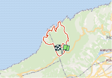
Tocht Stappen van 12,8 km beschikbaar op Autonome Gemeenschap Baskenland, Gipuzkoa, Hondarribia/Fontarrabie. Deze tocht wordt voorgesteld door DECHAMPD.
Beschrijving
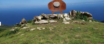
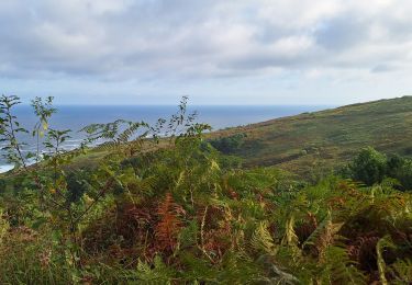
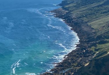
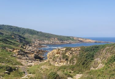
"Le Jaizkibel s'est formé à l'Éocène. A cette époque, une fosse marine sépare l'Europe (au niveau de Saint Jean de Luz) du bloc ibérique. A la fin de cette période (entre - 55 et - 45 millions d'années), le Pays basque commence à émerger.
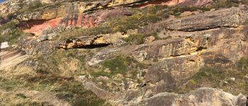
Je ne suis pas géologue et je ne me suis pas vraiment penchée sur la question. Tout ce que je peux vous dire, c'est que le Jaizkibel est un bel endroit pour les géologues et pour les béotiens dont je suis qui peuvent y admirer les paysages et des formations géologiques étonnantes dont certaines semblent façonnées par la main de l'homme. C'est aussi au Jaizkibel que l'on trouve les paramoudras, ces concrétions organisées autour d'un terrier de vers. Le mot de "paramoudra" vient du gaëlique peura muireach, "poire de mer". Ces formations très spécifiques se sont faites en général en milieu calcaire. Au Jaizkibel, elles se sont faites dans des grès, ce qui en fait leur particularité. Ces formations, de tailles très diverses, qui ont la forme de sphères presque parfaites ou de cylindres sont très abondantes, particulièrement dans certaines criques. Le paysage alentour a l'aspect de gruyère.
POI's
Plaatsbepaling
Opmerkingen
Wandeltochten in de omgeving
![Tocht Stappen Hondarribia/Fontarrabie - roro - Photo](https://media.geolcdn.com/t/375/260/ext.jpg?maxdim=2&url=https%3A%2F%2Fstatic1.geolcdn.com%2Fsiteimages%2Fupload%2Ffiles%2F1553511878bg_sport_marche.png)
![Stappen Stappen](https://static1.geolcdn.com/sitytour/trail-icons/101.png)
Stappen
![](/images/other/stat-length.png)
![](https://static1.geolcdn.com/siteimages/upload/files/16400158638029165_repeat_loop_refresh_sync_direction_icon.png)
![Tocht Stappen Hondarribia/Fontarrabie - Jaizkibel - Chemin côtier - Cap du Figuier - Notre-Dame de Guadalupe - Photo](https://media.geolcdn.com/t/375/260/ext.jpg?maxdim=2&url=https%3A%2F%2Fstatic1.geolcdn.com%2Fsiteimages%2Fupload%2Ffiles%2F1553511878bg_sport_marche.png)
![Stappen Stappen](https://static1.geolcdn.com/sitytour/trail-icons/101.png)
Stappen
![](/images/other/stat-length.png)
![](https://static1.geolcdn.com/siteimages/upload/files/16400158638029165_repeat_loop_refresh_sync_direction_icon.png)
![Tocht Stappen Hondarribia/Fontarrabie - Pasaia les vallées des couleurs - Photo](https://media.geolcdn.com/t/375/260/57f480d6-c56c-4ebd-ac8e-5bd675485a93.jpg&format=jpg&maxdim=2)
![Stappen Stappen](https://static1.geolcdn.com/sitytour/trail-icons/101.png)
Stappen
![](/images/other/stat-length.png)
![](https://static1.geolcdn.com/siteimages/upload/files/16400158638029165_repeat_loop_refresh_sync_direction_icon.png)
![Tocht Stappen Pasaia - Pasaia Donibane - Photo](https://media.geolcdn.com/t/375/260/0553a38d-8a0d-4fa0-800e-ecb893adf7b5.jpg&format=jpg&maxdim=2)
![Stappen Stappen](https://static1.geolcdn.com/sitytour/trail-icons/101.png)
Stappen
![](/images/other/stat-length.png)
![](https://static1.geolcdn.com/siteimages/upload/files/16400158638029165_repeat_loop_refresh_sync_direction_icon.png)
![Tocht Stappen Pasaia - Littoral du Jaizkibel I - Photo](https://media.geolcdn.com/t/375/260/c0b73d7c-a983-4f61-bb9e-e7eb6af85a90.jpeg&format=jpg&maxdim=2)
![Stappen Stappen](https://static1.geolcdn.com/sitytour/trail-icons/101.png)
Stappen
![](/images/other/stat-length.png)
![](https://static1.geolcdn.com/siteimages/upload/files/16400158638029165_repeat_loop_refresh_sync_direction_icon.png)
![Tocht Stappen Hondarribia/Fontarrabie - Fondarrabie sentier côtier bis - Photo](https://media.geolcdn.com/t/375/260/499622ed-279c-4bc8-a410-ec9c09f4d2c1.jpg&format=jpg&maxdim=2)
![Stappen Stappen](https://static1.geolcdn.com/sitytour/trail-icons/101.png)
Stappen
![](/images/other/stat-length.png)
![](https://static1.geolcdn.com/siteimages/upload/files/16400158638029165_repeat_loop_refresh_sync_direction_icon.png)
![Tocht Stappen Hondarribia/Fontarrabie - hondarribia cap figuier - Photo](https://media.geolcdn.com/t/375/260/ace45812-18e3-4fc6-bc81-bbde70a3189c.jpg&format=jpg&maxdim=2)
![Stappen Stappen](https://static1.geolcdn.com/sitytour/trail-icons/101.png)
Stappen
![](/images/other/stat-length.png)
![](https://static1.geolcdn.com/siteimages/upload/files/16400158638029165_repeat_loop_refresh_sync_direction_icon.png)
![Tocht Stappen Pasaia - Piemont du Jaizkibel Pays Basque Espagne - Photo](https://media.geolcdn.com/t/375/260/fd334848-f3d2-471b-86a8-42eac21c68f8.jpg&format=jpg&maxdim=2)
![Stappen Stappen](https://static1.geolcdn.com/sitytour/trail-icons/101.png)
Stappen
![](/images/other/stat-length.png)
![](https://static1.geolcdn.com/siteimages/upload/files/16400158638029165_repeat_loop_refresh_sync_direction_icon.png)