![](/images/other/stat-length.png)
![Tocht Mountainbike Montélimar - 2022_10_10_Montélo-Bourg-St-Andéol - Photo](https://media.geolcdn.com/t/1900/400/ext.pjpeg?maxdim=2&url=https%3A%2F%2Fstatic1.geolcdn.com%2Fsiteimages%2Fupload%2Ffiles%2F1524743154velo.jpg)
2022_10_10_Montélo-Bourg-St-Andéol
Chamois30
Gebruiker
![Lengte](/images/other/stat-length.png)
Lengte
67 km
![Max. hoogte](https://static1.geolcdn.com/siteimages/upload/files/1508320355ic_sort_altitude_max_24dp.png)
Max. hoogte
98 m
![Positief hoogteverschil](https://static1.geolcdn.com/siteimages/upload/files/1508320355ic_sort_den_pos_24dp.png)
Positief hoogteverschil
528 m
![Km-Effort](/images/other/stat-length.png)
Km-Effort
74 km
![Min. hoogte](https://static1.geolcdn.com/siteimages/upload/files/1508320355ic_sort_altitude_min_24dp.png)
Min. hoogte
49 m
![Negatief hoogteverschil](https://static1.geolcdn.com/siteimages/upload/files/1508320355ic_sort_den_neg_24dp.png)
Negatief hoogteverschil
528 m
![Boucle](https://static1.geolcdn.com/siteimages/upload/files/16400158638029165_repeat_loop_refresh_sync_direction_icon.png)
Boucle
Ja
Datum van aanmaak :
2022-10-10 12:03:50.776
Laatste wijziging :
2022-10-11 07:23:13.878
![Mountainbike](https://static1.geolcdn.com/sitytour/trail-icons/202.png)
3h56
Moeilijkheid : Medium
![Scan deze QR-code om de tocht te openen in de SityTrail-applicatie](https://capi.geolives.com/qq0zvz2zws4bq2lad0pu/sitytour/trails/3420098/qr.png?size=200)
Gratisgps-wandelapplicatie
Over ons
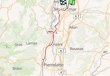
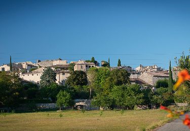
Tocht Mountainbike van 67 km beschikbaar op Auvergne-Rhône-Alpes, Drôme, Montélimar. Deze tocht wordt voorgesteld door Chamois30.
Beschrijving
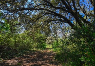
crochet par le quartier du Puits à Viviers
Un gros doute sur les dénivelés /- de /- 528m
Ce serait plus de l'ordre de /-120 m ??? A vérifier
Plaatsbepaling
Land:
France
Regio :
Auvergne-Rhône-Alpes
Departement/Provincie :
Drôme
Gemeente :
Montélimar
Locatie:
Unknown
Vertrek:(Dec)
Vertrek:(UTM)
639931 ; 4935473 (31T) N.
Opmerkingen
Wandeltochten in de omgeving
![Tocht Stappen Montélimar - Gournier Châteauneuf-du-Rhône 10km. - Photo](https://media.geolcdn.com/t/375/260/a08a9331-95c4-4920-937a-59a5efd2ede5.jpg&format=jpg&maxdim=2)
![Stappen Stappen](https://static1.geolcdn.com/sitytour/trail-icons/101.png)
Gournier Châteauneuf-du-Rhône 10km.
Stappen
Gemakkelijk
(1)
Montélimar,
Auvergne-Rhône-Alpes,
Drôme,
France
![](/images/other/stat-length.png)
9,3 km | 10,1 km-effort
1h 37min
![](https://static1.geolcdn.com/siteimages/upload/files/16400158638029165_repeat_loop_refresh_sync_direction_icon.png)
Ja
![Tocht Stappen Sauzet - Sauzet Les Grands Abris 7km5 - Photo](https://media.geolcdn.com/t/375/260/dc904df7-2d15-4473-9afc-0180c6e306df.jpg&format=jpg&maxdim=2)
![Stappen Stappen](https://static1.geolcdn.com/sitytour/trail-icons/101.png)
Sauzet Les Grands Abris 7km5
Stappen
Medium
(1)
Sauzet,
Auvergne-Rhône-Alpes,
Drôme,
France
![](/images/other/stat-length.png)
7,3 km | 11,7 km-effort
2h 26min
![](https://static1.geolcdn.com/siteimages/upload/files/16400158638029165_repeat_loop_refresh_sync_direction_icon.png)
Ja
![Tocht Stappen Rochemaure - Rochemaure - Photo](https://media.geolcdn.com/t/375/260/ext.jpg?maxdim=2&url=https%3A%2F%2Fservices.sitytrail.com%2FGeolivesWS%2FDownloadMedia.ashx%3FTrailID%3D109893%26Media%3D4900_1.jpg)
![Stappen Stappen](https://static1.geolcdn.com/sitytour/trail-icons/101.png)
Rochemaure
Stappen
Medium
(3)
Rochemaure,
Auvergne-Rhône-Alpes,
Ardèche,
France
![](/images/other/stat-length.png)
8,8 km | 13,6 km-effort
3h 0min
![](https://static1.geolcdn.com/siteimages/upload/files/16400158638029165_repeat_loop_refresh_sync_direction_icon.png)
Ja
![Tocht Stappen Saint-Marcel-lès-Sauzet - 2022-09-27_13h20m15_14402792 - Photo](https://media.geolcdn.com/t/375/260/9b95d8f7-96bf-4e7c-a753-aa87110b6003.jpeg&format=jpg&maxdim=2)
![Stappen Stappen](https://static1.geolcdn.com/sitytour/trail-icons/101.png)
2022-09-27_13h20m15_14402792
Stappen
Gemakkelijk
Saint-Marcel-lès-Sauzet,
Auvergne-Rhône-Alpes,
Drôme,
France
![](/images/other/stat-length.png)
6,3 km | 9 km-effort
2h 1min
![](https://static1.geolcdn.com/siteimages/upload/files/16400158638029165_repeat_loop_refresh_sync_direction_icon.png)
Ja
![Tocht Stappen Sauzet - 2022-09-27_13h19m12_14402793-2 - Photo](https://media.geolcdn.com/t/375/260/7a0f940a-b445-4320-8788-dc8b4c52f3c2.jpg&format=jpg&maxdim=2)
![Stappen Stappen](https://static1.geolcdn.com/sitytour/trail-icons/101.png)
2022-09-27_13h19m12_14402793-2
Stappen
Medium
Sauzet,
Auvergne-Rhône-Alpes,
Drôme,
France
![](/images/other/stat-length.png)
7,3 km | 11,8 km-effort
2h 40min
![](https://static1.geolcdn.com/siteimages/upload/files/16400158638029165_repeat_loop_refresh_sync_direction_icon.png)
Ja
![Tocht Stappen Ancône - 2022-09-27_13h14m41_14402810-1 - Photo](https://media.geolcdn.com/t/375/260/cb008533-e372-48c7-9f09-091e6cae99d0.jpg&format=jpg&maxdim=2)
![Stappen Stappen](https://static1.geolcdn.com/sitytour/trail-icons/101.png)
2022-09-27_13h14m41_14402810-1
Stappen
Medium
Ancône,
Auvergne-Rhône-Alpes,
Drôme,
France
![](/images/other/stat-length.png)
16,1 km | 17,6 km-effort
4h 0min
![](https://static1.geolcdn.com/siteimages/upload/files/16400158638029165_repeat_loop_refresh_sync_direction_icon.png)
Ja
![Tocht Noords wandelen Montélimar - 20191002 MN Hymalaya - Photo](https://media.geolcdn.com/t/375/260/ext.jpg?maxdim=2&url=https%3A%2F%2Fstatic1.geolcdn.com%2Fsiteimages%2Fupload%2Ffiles%2F1545311037marcheuse_200dpi.jpg)
![Noords wandelen Noords wandelen](https://static1.geolcdn.com/sitytour/trail-icons/102.png)
20191002 MN Hymalaya
Noords wandelen
Heel gemakkelijk
(1)
Montélimar,
Auvergne-Rhône-Alpes,
Drôme,
France
![](/images/other/stat-length.png)
7,7 km | 8,4 km-effort
1h 49min
![](https://static1.geolcdn.com/siteimages/upload/files/16400158638029165_repeat_loop_refresh_sync_direction_icon.png)
Ja
![Tocht Stappen Rochemaure - tour du chenavari - Photo](https://media.geolcdn.com/t/375/260/ext.jpg?maxdim=2&url=https%3A%2F%2Fstatic1.geolcdn.com%2Fsiteimages%2Fupload%2Ffiles%2F1553511878bg_sport_marche.png)
![Stappen Stappen](https://static1.geolcdn.com/sitytour/trail-icons/101.png)
tour du chenavari
Stappen
Medium
(1)
Rochemaure,
Auvergne-Rhône-Alpes,
Ardèche,
France
![](/images/other/stat-length.png)
6,3 km | 9,5 km-effort
2h 0min
![](https://static1.geolcdn.com/siteimages/upload/files/16400158638029165_repeat_loop_refresh_sync_direction_icon.png)
Ja
![Tocht Stappen Rochemaure - Château de Rochemaure, Pic de Chenavari. - Photo](https://media.geolcdn.com/t/375/260/6c8a3c6f-4dcf-44b9-a997-a4440eb044c8.jpg&format=jpg&maxdim=2)
![Stappen Stappen](https://static1.geolcdn.com/sitytour/trail-icons/101.png)
Château de Rochemaure, Pic de Chenavari.
Stappen
Moeilijk
Rochemaure,
Auvergne-Rhône-Alpes,
Ardèche,
France
![](/images/other/stat-length.png)
16,6 km | 26 km-effort
5h 58min
![](https://static1.geolcdn.com/siteimages/upload/files/16400158638029165_repeat_loop_refresh_sync_direction_icon.png)
Ja