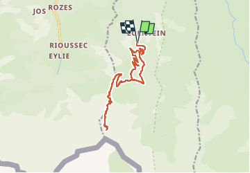
![](/images/other/stat-length.png)
![Tocht Stappen Bonac-Irazein - Mines de Bulard - Photo](https://media.geolcdn.com/t/1900/400/ext.pjpeg?maxdim=2&url=https%3A%2F%2Fstatic1.geolcdn.com%2Fsiteimages%2Fupload%2Ffiles%2F1553511878bg_sport_marche.png)
Mines de Bulard
dawed311
Gebruiker
![Lengte](/images/other/stat-length.png)
![Max. hoogte](https://static1.geolcdn.com/siteimages/upload/files/1508320355ic_sort_altitude_max_24dp.png)
![Positief hoogteverschil](https://static1.geolcdn.com/siteimages/upload/files/1508320355ic_sort_den_pos_24dp.png)
![Km-Effort](/images/other/stat-length.png)
![Min. hoogte](https://static1.geolcdn.com/siteimages/upload/files/1508320355ic_sort_altitude_min_24dp.png)
![Negatief hoogteverschil](https://static1.geolcdn.com/siteimages/upload/files/1508320355ic_sort_den_neg_24dp.png)
![Boucle](https://static1.geolcdn.com/siteimages/upload/files/16400158638029165_repeat_loop_refresh_sync_direction_icon.png)
![Stappen](https://static1.geolcdn.com/sitytour/trail-icons/101.png)
6h27
Moeilijkheid : Moeilijk
![Scan deze QR-code om de tocht te openen in de SityTrail-applicatie](https://capi.geolives.com/qq0zvz2zws4bq2lad0pu/sitytour/trails/3419289/qr.png?size=200)
Gratisgps-wandelapplicatie
Over ons
Tocht Stappen van 18 km beschikbaar op Occitanië, Ariège, Bonac-Irazein. Deze tocht wordt voorgesteld door dawed311.
Beschrijving
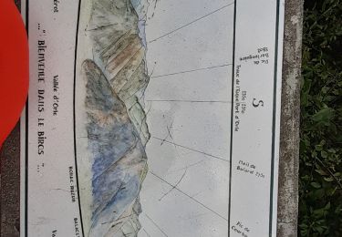
Attention piste très défoncée jusqu'à 1100m, en meilleur état au dessus jusqu'à la barrière.
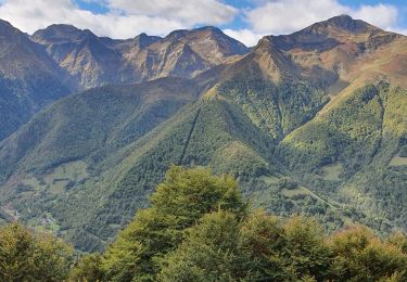
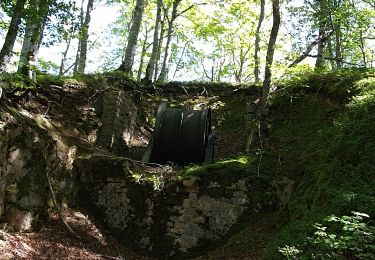
Rien de difficile hormis le dénivelé et la longueur mais le chemin est évident et monte en lacets faciles et réguliers. La mine la plus proche est facilement accessible malgré un court passage exposé. Pour le reste des mines, le chemin est avant le passage exposé, continuer la grimpette après le relais pour découvrir le chemin vertigineux.
La vue des baraquements porte vers le Vallier, bouchée par la crête nord du Bulard côté Serre Haute-Crabere. Malgré, le mini Macchu Picchu ariégeois mérite une visite.
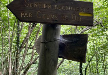
(Oubli de couper le gps pendant le casse croute, puis non pris sur le sentier des mines)
Plaatsbepaling
Opmerkingen
Wandeltochten in de omgeving
![Tocht Stappen Sentein - M008-Frechendech à Etang ARAING - Photo](https://media.geolcdn.com/t/375/260/ext.jpg?maxdim=2&url=https%3A%2F%2Fstatic1.geolcdn.com%2Fsiteimages%2Fupload%2Ffiles%2F1553511878bg_sport_marche.png)
![Stappen Stappen](https://static1.geolcdn.com/sitytour/trail-icons/101.png)
Stappen
![](/images/other/stat-length.png)
![](https://static1.geolcdn.com/siteimages/upload/files/16400158638029165_repeat_loop_refresh_sync_direction_icon.png)
![Tocht Stappen Sentein - Araing Crabère - Photo](https://media.geolcdn.com/t/375/260/ext.jpg?maxdim=2&url=https%3A%2F%2Fstatic1.geolcdn.com%2Fsiteimages%2Fupload%2Ffiles%2F1553511878bg_sport_marche.png)
![Stappen Stappen](https://static1.geolcdn.com/sitytour/trail-icons/101.png)
Stappen
![](/images/other/stat-length.png)
![](https://static1.geolcdn.com/siteimages/upload/files/16400158638029165_repeat_loop_refresh_sync_direction_icon.png)
![Tocht Stappen Bonac-Irazein - Pic de Courbayran et cabane de Roques - Photo](https://media.geolcdn.com/t/375/260/aea92664-82b8-439f-8945-426d5859ad83.jpg&format=jpg&maxdim=2)
![Stappen Stappen](https://static1.geolcdn.com/sitytour/trail-icons/101.png)
Stappen
![](/images/other/stat-length.png)
![](https://static1.geolcdn.com/siteimages/upload/files/16400158638029165_repeat_loop_refresh_sync_direction_icon.png)
![Tocht Stappen Bonac-Irazein - tunnels du Biros ou sentier Decauville - Photo](https://media.geolcdn.com/t/375/260/2ced53d3-2fbe-4fc5-97f5-bde97ee00210.jpg&format=jpg&maxdim=2)
![Stappen Stappen](https://static1.geolcdn.com/sitytour/trail-icons/101.png)
Stappen
![](/images/other/stat-length.png)
![](https://static1.geolcdn.com/siteimages/upload/files/16400158638029165_repeat_loop_refresh_sync_direction_icon.png)
![Tocht Stappen Bonac-Irazein - Sentier du port d’Orle - col du Tuc - Photo](https://media.geolcdn.com/t/375/260/74662a78-0f2f-48cd-8c55-5df1361685fc.jpg&format=jpg&maxdim=2)
![Stappen Stappen](https://static1.geolcdn.com/sitytour/trail-icons/101.png)
Stappen
![](/images/other/stat-length.png)
![](https://static1.geolcdn.com/siteimages/upload/files/16400158638029165_repeat_loop_refresh_sync_direction_icon.png)
![Tocht Te voet Bordes-Uchentein - Étangs Long et Rond - Photo](https://media.geolcdn.com/t/375/260/a3cac1de-06a6-41d0-ac66-ed9400aa294d.jpeg&format=jpg&maxdim=2)
![Te voet Te voet](https://static1.geolcdn.com/sitytour/trail-icons/100.png)
Te voet
![](/images/other/stat-length.png)
![](https://static1.geolcdn.com/siteimages/upload/files/16400158638029165_repeat_loop_refresh_sync_direction_icon.png)
![Tocht Stappen Balacet - Pic de l'Arraing - Photo](https://media.geolcdn.com/t/375/260/d786b34b-d7df-4e3d-872e-cbcf51d1d34e.jpg&format=jpg&maxdim=2)
![Stappen Stappen](https://static1.geolcdn.com/sitytour/trail-icons/101.png)
Stappen
![](/images/other/stat-length.png)
![](https://static1.geolcdn.com/siteimages/upload/files/16400158638029165_repeat_loop_refresh_sync_direction_icon.png)
![Tocht Stappen Sentein - Cabane d'Illau et chapelle de l'izard - Photo](https://media.geolcdn.com/t/375/260/c0706c8c-fa40-4518-8b57-65ce31db604f.jpg&format=jpg&maxdim=2)
![Stappen Stappen](https://static1.geolcdn.com/sitytour/trail-icons/101.png)
Stappen
![](/images/other/stat-length.png)
![](https://static1.geolcdn.com/siteimages/upload/files/16400158638029165_repeat_loop_refresh_sync_direction_icon.png)
![Tocht Stappen Antras - Le tour du Mail des Morères - Photo](https://media.geolcdn.com/t/375/260/ext.jpg?maxdim=2&url=https%3A%2F%2Fstatic1.geolcdn.com%2Fsiteimages%2Fupload%2Ffiles%2F1553511878bg_sport_marche.png)
![Stappen Stappen](https://static1.geolcdn.com/sitytour/trail-icons/101.png)
Stappen
![](/images/other/stat-length.png)
![](https://static1.geolcdn.com/siteimages/upload/files/16400158638029165_repeat_loop_refresh_sync_direction_icon.png)