![](/images/other/stat-length.png)
![Tocht Stappen Fontpédrouse - Carença-Mont-Louis - Photo](https://media.geolcdn.com/t/1900/400/ext.pjpeg?maxdim=2&url=https%3A%2F%2Fstatic1.geolcdn.com%2Fsiteimages%2Fupload%2Ffiles%2F1553511878bg_sport_marche.png)
Carença-Mont-Louis
georghinio
Gebruiker
![Lengte](/images/other/stat-length.png)
Lengte
18,2 km
![Max. hoogte](https://static1.geolcdn.com/siteimages/upload/files/1508320355ic_sort_altitude_max_24dp.png)
Max. hoogte
2387 m
![Positief hoogteverschil](https://static1.geolcdn.com/siteimages/upload/files/1508320355ic_sort_den_pos_24dp.png)
Positief hoogteverschil
1046 m
![Km-Effort](/images/other/stat-length.png)
Km-Effort
33 km
![Min. hoogte](https://static1.geolcdn.com/siteimages/upload/files/1508320355ic_sort_altitude_min_24dp.png)
Min. hoogte
1475 m
![Negatief hoogteverschil](https://static1.geolcdn.com/siteimages/upload/files/1508320355ic_sort_den_neg_24dp.png)
Negatief hoogteverschil
1423 m
![Boucle](https://static1.geolcdn.com/siteimages/upload/files/16400158638029165_repeat_loop_refresh_sync_direction_icon.png)
Boucle
Neen
Datum van aanmaak :
2022-10-05 07:53:14.449
Laatste wijziging :
2022-10-05 07:55:55.344
![Stappen](https://static1.geolcdn.com/sitytour/trail-icons/101.png)
7h35
Moeilijkheid : Zeer moeilijk
![Scan deze QR-code om de tocht te openen in de SityTrail-applicatie](https://capi.geolives.com/qq0zvz2zws4bq2lad0pu/sitytour/trails/3413310/qr.png?size=200)
Gratisgps-wandelapplicatie
Over ons
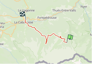
Tocht Stappen van 18,2 km beschikbaar op Occitanië, Pyrénées-Orientales, Fontpédrouse. Deze tocht wordt voorgesteld door georghinio.
Beschrijving
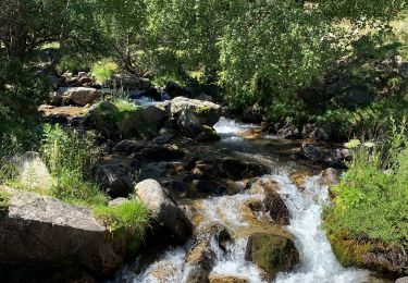
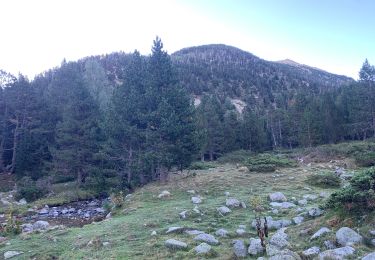
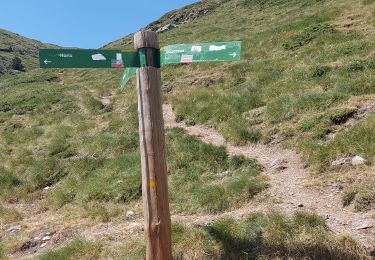
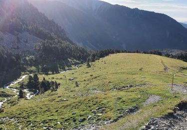
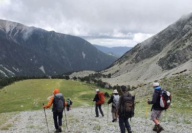
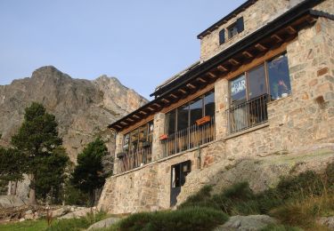
Départ ruisseau avant refuge de la Carença puis arrivée à Mont-Louis(hors Gr10)
Rando longue mais aucune difficulté particulière
Magnifique vue au col Mitja sur Font Romeu et ses voisins
Plaatsbepaling
Land:
France
Regio :
Occitanië
Departement/Provincie :
Pyrénées-Orientales
Gemeente :
Fontpédrouse
Locatie:
Unknown
Vertrek:(Dec)
Vertrek:(UTM)
436768 ; 4701247 (31T) N.
Opmerkingen
Wandeltochten in de omgeving
![Tocht Stappen Fontpédrouse - Tour du Cucurucull - Photo](https://media.geolcdn.com/t/375/260/ext.jpg?maxdim=2&url=https%3A%2F%2Fservices.sitytrail.com%2FGeolivesWS%2FDownloadMedia.ashx%3FTrailID%3D376769%26Media%3Dfix__20150112140709.jpg)
![Stappen Stappen](https://static1.geolcdn.com/sitytour/trail-icons/101.png)
Tour du Cucurucull
Stappen
Medium
(1)
Fontpédrouse,
Occitanië,
Pyrénées-Orientales,
France
![](/images/other/stat-length.png)
9,3 km | 18,5 km-effort
3h 24min
![](https://static1.geolcdn.com/siteimages/upload/files/16400158638029165_repeat_loop_refresh_sync_direction_icon.png)
Ja
![Tocht Stappen Fontpédrouse - 2022 TRANSPYRÉNÉENNE : refuge du Ras de la Carança - Photo](https://media.geolcdn.com/t/375/260/ext.jpg?maxdim=2&url=https%3A%2F%2Fmedia.geolcdn.com%2Ff%2Ff5ce2549-8db0-4469-a943-a23fcb97a879.jpg)
![Stappen Stappen](https://static1.geolcdn.com/sitytour/trail-icons/101.png)
2022 TRANSPYRÉNÉENNE : refuge du Ras de la Carança
Stappen
Moeilijk
Fontpédrouse,
Occitanië,
Pyrénées-Orientales,
France
![](/images/other/stat-length.png)
17,2 km | 31 km-effort
4h 36min
![](https://static1.geolcdn.com/siteimages/upload/files/16400158638029165_repeat_loop_refresh_sync_direction_icon.png)
Neen
![Tocht Stappen Setcases - ulldeter - Nuria - Photo](https://media.geolcdn.com/t/375/260/ext.jpg?maxdim=2&url=https%3A%2F%2Fmedia.geolcdn.com%2Ff%2F86190e6f-d09d-437c-91bf-dda7a844ca8c.jpg)
![Stappen Stappen](https://static1.geolcdn.com/sitytour/trail-icons/101.png)
ulldeter - Nuria
Stappen
Zeer moeilijk
Setcases,
Catalonië,
Gerona,
Spain
![](/images/other/stat-length.png)
12,8 km | 26 km-effort
8h 10min
![](https://static1.geolcdn.com/siteimages/upload/files/16400158638029165_repeat_loop_refresh_sync_direction_icon.png)
Neen
![Tocht Stappen Setcases - refugi ull de ter à Nuria - - Photo](https://media.geolcdn.com/t/375/260/ext.jpg?maxdim=2&url=https%3A%2F%2Fmedia.geolcdn.com%2Ff%2F74e07d74-a5dd-447c-afab-41e56373bd3a.jpg)
![Stappen Stappen](https://static1.geolcdn.com/sitytour/trail-icons/101.png)
refugi ull de ter à Nuria -
Stappen
Moeilijk
Setcases,
Catalonië,
Gerona,
Spain
![](/images/other/stat-length.png)
15,6 km | 26 km-effort
7h 54min
![](https://static1.geolcdn.com/siteimages/upload/files/16400158638029165_repeat_loop_refresh_sync_direction_icon.png)
Neen
![Tocht Stappen Fontpédrouse - Refuges Ras Carança - Ulldeter via col del Geant - Photo](https://media.geolcdn.com/t/375/260/ext.jpg?maxdim=2&url=https%3A%2F%2Fmedia.geolcdn.com%2Ff%2F1db565fb-0284-4d6c-9495-de82535d6b22.jpg)
![Stappen Stappen](https://static1.geolcdn.com/sitytour/trail-icons/101.png)
Refuges Ras Carança - Ulldeter via col del Geant
Stappen
Medium
Fontpédrouse,
Occitanië,
Pyrénées-Orientales,
France
![](/images/other/stat-length.png)
8,9 km | 19 km-effort
6h 10min
![](https://static1.geolcdn.com/siteimages/upload/files/16400158638029165_repeat_loop_refresh_sync_direction_icon.png)
Neen
![Tocht Stappen Fontpédrouse - Carenza à la perche - Photo](https://media.geolcdn.com/t/375/260/ext.jpg?maxdim=2&url=https%3A%2F%2Fmedia.geolcdn.com%2Ff%2Fe5129642-9fc2-49eb-8e63-ecc481cd1928.jpg)
![Stappen Stappen](https://static1.geolcdn.com/sitytour/trail-icons/101.png)
Carenza à la perche
Stappen
Moeilijk
Fontpédrouse,
Occitanië,
Pyrénées-Orientales,
France
![](/images/other/stat-length.png)
23 km | 38 km-effort
8h 57min
![](https://static1.geolcdn.com/siteimages/upload/files/16400158638029165_repeat_loop_refresh_sync_direction_icon.png)
Neen
![Tocht Stappen Setcases - ull de terr pla guillhem - Photo](https://media.geolcdn.com/t/375/260/ext.jpg?maxdim=2&url=https%3A%2F%2Fmedia.geolcdn.com%2Ff%2F47c06ead-a976-4d95-8a1d-6c4c2a5fd37b.JPG)
![Stappen Stappen](https://static1.geolcdn.com/sitytour/trail-icons/101.png)
ull de terr pla guillhem
Stappen
Zeer moeilijk
Setcases,
Catalonië,
Gerona,
Spain
![](/images/other/stat-length.png)
16,5 km | 27 km-effort
5h 35min
![](https://static1.geolcdn.com/siteimages/upload/files/16400158638029165_repeat_loop_refresh_sync_direction_icon.png)
Neen
![Tocht Sneeuwschoenen Fontpédrouse - boucle autour du Cucurucull - Photo](https://media.geolcdn.com/t/375/260/ext.jpg?maxdim=2&url=https%3A%2F%2Fservices.sitytrail.com%2FGeolivesWS%2FDownloadMedia.ashx%3FTrailID%3D911352%26Media%3Dfix__20180222143556.jpg)
![Sneeuwschoenen Sneeuwschoenen](https://static1.geolcdn.com/sitytour/trail-icons/504.png)
boucle autour du Cucurucull
Sneeuwschoenen
Moeilijk
Fontpédrouse,
Occitanië,
Pyrénées-Orientales,
France
![](/images/other/stat-length.png)
12,8 km | 27 km-effort
7h 21min
![](https://static1.geolcdn.com/siteimages/upload/files/16400158638029165_repeat_loop_refresh_sync_direction_icon.png)
Ja
![Tocht Stappen Fontpédrouse - Prats Balaguer a l'Estaniol - Photo](https://media.geolcdn.com/t/375/260/ext.jpg?maxdim=2&url=https%3A%2F%2Fservices.sitytrail.com%2FGeolivesWS%2FDownloadMedia.ashx%3FTrailID%3D823776%26Media%3D20170905125219.jpg)
![Stappen Stappen](https://static1.geolcdn.com/sitytour/trail-icons/101.png)
Prats Balaguer a l'Estaniol
Stappen
Moeilijk
Fontpédrouse,
Occitanië,
Pyrénées-Orientales,
France
![](/images/other/stat-length.png)
18,3 km | 32 km-effort
5h 5min
![](https://static1.geolcdn.com/siteimages/upload/files/16400158638029165_repeat_loop_refresh_sync_direction_icon.png)
Ja