![](/images/other/stat-length.png)
![Tocht Stappen Roqueredonde - Roqueredonde (val d'Orb, centre bouddhique, foret d'Escandorgue) - Photo](https://media.geolcdn.com/t/1900/400/ext.pjpeg?maxdim=2&url=https%3A%2F%2Fstatic1.geolcdn.com%2Fsiteimages%2Fupload%2Ffiles%2F1553511878bg_sport_marche.png)
Roqueredonde (val d'Orb, centre bouddhique, foret d'Escandorgue)
coulombf
Gebruiker
![Lengte](/images/other/stat-length.png)
Lengte
15,9 km
![Max. hoogte](https://static1.geolcdn.com/siteimages/upload/files/1508320355ic_sort_altitude_max_24dp.png)
Max. hoogte
846 m
![Positief hoogteverschil](https://static1.geolcdn.com/siteimages/upload/files/1508320355ic_sort_den_pos_24dp.png)
Positief hoogteverschil
533 m
![Km-Effort](/images/other/stat-length.png)
Km-Effort
23 km
![Min. hoogte](https://static1.geolcdn.com/siteimages/upload/files/1508320355ic_sort_altitude_min_24dp.png)
Min. hoogte
522 m
![Negatief hoogteverschil](https://static1.geolcdn.com/siteimages/upload/files/1508320355ic_sort_den_neg_24dp.png)
Negatief hoogteverschil
533 m
![Boucle](https://static1.geolcdn.com/siteimages/upload/files/16400158638029165_repeat_loop_refresh_sync_direction_icon.png)
Boucle
Ja
Datum van aanmaak :
2022-09-29 07:50:23.0
Laatste wijziging :
2022-10-03 20:46:46.637
![Stappen](https://static1.geolcdn.com/sitytour/trail-icons/101.png)
5h08
Moeilijkheid : Medium
![Scan deze QR-code om de tocht te openen in de SityTrail-applicatie](https://capi.geolives.com/qq0zvz2zws4bq2lad0pu/sitytour/trails/3407367/qr.png?size=200)
Gratisgps-wandelapplicatie
Over ons
Tocht Stappen van 15,9 km beschikbaar op Occitanië, Hérault, Roqueredonde. Deze tocht wordt voorgesteld door coulombf.
Beschrijving
27/08/2020 Reconnaissance avec Jacques et Nicole Brivet, Lyane Bergerioux, Catherine Bruguier.
29/09/2022 groupe marche FC
Inspiré de la Gazette n°1679 du 20 au 26/08/2020
Plaatsbepaling
Land:
France
Regio :
Occitanië
Departement/Provincie :
Hérault
Gemeente :
Roqueredonde
Locatie:
Unknown
Vertrek:(Dec)
Vertrek:(UTM)
517136 ; 4849704 (31T) N.
Opmerkingen
Wandeltochten in de omgeving
![Tocht Noords wandelen Lauroux - SityTrail - Labeil Forêt de l'Escandorgue Juin 2021 - Photo](https://media.geolcdn.com/t/375/260/ext.jpg?maxdim=2&url=https%3A%2F%2Fmedia.geolcdn.com%2Ff%2Fc2282928-f752-4149-927b-0f9ea4e169ca.jpg)
![Noords wandelen Noords wandelen](https://static1.geolcdn.com/sitytour/trail-icons/102.png)
SityTrail - Labeil Forêt de l'Escandorgue Juin 2021
Noords wandelen
Gemakkelijk
(1)
Lauroux,
Occitanië,
Hérault,
France
![](/images/other/stat-length.png)
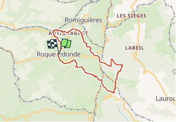
9,3 km | 12,5 km-effort
Onbekend
![](https://static1.geolcdn.com/siteimages/upload/files/16400158638029165_repeat_loop_refresh_sync_direction_icon.png)
Ja
![Tocht Stappen Les Plans - Forêt domaniale d'Escandorgue par Roqueredonde et l'Engayresque - Photo](https://media.geolcdn.com/t/375/260/ext.jpg?maxdim=2&url=https%3A%2F%2Fmedia.geolcdn.com%2Ff%2Fc203cd03-9ac1-4e05-8a4c-6b4e6f9317be.jpg)
![Stappen Stappen](https://static1.geolcdn.com/sitytour/trail-icons/101.png)
Forêt domaniale d'Escandorgue par Roqueredonde et l'Engayresque
Stappen
Medium
(1)
Les Plans,
Occitanië,
Hérault,
France
![](/images/other/stat-length.png)
14,2 km | 19,7 km-effort
5h 2min
![](https://static1.geolcdn.com/siteimages/upload/files/16400158638029165_repeat_loop_refresh_sync_direction_icon.png)
Ja
![Tocht Stappen Lauroux - cirque de labeil - Photo](https://media.geolcdn.com/t/375/260/ext.jpg?maxdim=2&url=https%3A%2F%2Fservices.sitytrail.com%2FGeolivesWS%2FDownloadMedia.ashx%3FTrailID%3D199890%26Media%3D20130622153523.jpg)
![Stappen Stappen](https://static1.geolcdn.com/sitytour/trail-icons/101.png)
cirque de labeil
Stappen
Gemakkelijk
(2)
Lauroux,
Occitanië,
Hérault,
France
![](/images/other/stat-length.png)
10,7 km | 14,1 km-effort
3h 4min
![](https://static1.geolcdn.com/siteimages/upload/files/16400158638029165_repeat_loop_refresh_sync_direction_icon.png)
Ja
![Tocht Stappen Lauroux - Lauroux (cirque de Labeil, l'Escandorgue) - Photo](https://media.geolcdn.com/t/375/260/ext.jpg?maxdim=2&url=https%3A%2F%2Fstatic1.geolcdn.com%2Fsiteimages%2Fupload%2Ffiles%2F1553511878bg_sport_marche.png)
![Stappen Stappen](https://static1.geolcdn.com/sitytour/trail-icons/101.png)
Lauroux (cirque de Labeil, l'Escandorgue)
Stappen
Gemakkelijk
(1)
Lauroux,
Occitanië,
Hérault,
France
![](/images/other/stat-length.png)
13,3 km | 18,5 km-effort
5h 22min
![](https://static1.geolcdn.com/siteimages/upload/files/16400158638029165_repeat_loop_refresh_sync_direction_icon.png)
Ja
![Tocht Stappen Cornus - guilhaumard n 1 col de licous au col de licous - Photo](https://media.geolcdn.com/t/375/260/ext.jpg?maxdim=2&url=https%3A%2F%2Fstatic1.geolcdn.com%2Fsiteimages%2Fupload%2Ffiles%2F1553511878bg_sport_marche.png)
![Stappen Stappen](https://static1.geolcdn.com/sitytour/trail-icons/101.png)
guilhaumard n 1 col de licous au col de licous
Stappen
Gemakkelijk
(2)
Cornus,
Occitanië,
Aveyron,
France
![](/images/other/stat-length.png)
14 km | 16,6 km-effort
3h 44min
![](https://static1.geolcdn.com/siteimages/upload/files/16400158638029165_repeat_loop_refresh_sync_direction_icon.png)
Ja
![Tocht Stappen Les Plans - Forêt et cirque de Labeil - Photo](https://media.geolcdn.com/t/375/260/ext.jpg?maxdim=2&url=https%3A%2F%2Fmedia.geolcdn.com%2Ff%2F21b3d7b0-35ee-491f-98e6-53e535349997.jpg)
![Stappen Stappen](https://static1.geolcdn.com/sitytour/trail-icons/101.png)
Forêt et cirque de Labeil
Stappen
Gemakkelijk
Les Plans,
Occitanië,
Hérault,
France
![](/images/other/stat-length.png)
12,5 km | 16,7 km-effort
4h 30min
![](https://static1.geolcdn.com/siteimages/upload/files/16400158638029165_repeat_loop_refresh_sync_direction_icon.png)
Ja
![Tocht Te voet Les Rives - Randonnée du 07/06/2022 à 09:14 - Photo](https://media.geolcdn.com/t/375/260/ext.jpg?maxdim=2&url=https%3A%2F%2Fmedia.geolcdn.com%2Ff%2F16545ddc-2e01-4c57-bc66-aedbefc75782.jpg)
![Te voet Te voet](https://static1.geolcdn.com/sitytour/trail-icons/100.png)
Randonnée du 07/06/2022 à 09:14
Te voet
Gemakkelijk
Les Rives,
Occitanië,
Hérault,
France
![](/images/other/stat-length.png)
14,3 km | 17,1 km-effort
3h 53min
![](https://static1.geolcdn.com/siteimages/upload/files/16400158638029165_repeat_loop_refresh_sync_direction_icon.png)
Ja
![Tocht Noords wandelen Les Plans - Perthus Grézac Domen - Photo](https://media.geolcdn.com/t/375/260/ext.jpg?maxdim=2&url=https%3A%2F%2Fmedia.geolcdn.com%2Ff%2F597d0d8d-6290-4b25-8571-e1b6b884046d.JPG)
![Noords wandelen Noords wandelen](https://static1.geolcdn.com/sitytour/trail-icons/102.png)
Perthus Grézac Domen
Noords wandelen
Heel gemakkelijk
Les Plans,
Occitanië,
Hérault,
France
![](/images/other/stat-length.png)
10,4 km | 13 km-effort
2h 24min
![](https://static1.geolcdn.com/siteimages/upload/files/16400158638029165_repeat_loop_refresh_sync_direction_icon.png)
Ja
![Tocht Noords wandelen Lauroux - Labeil Forêt de l'Escandorgue Juin 2021 - Photo](https://media.geolcdn.com/t/375/260/ext.jpg?maxdim=2&url=https%3A%2F%2Fmedia.geolcdn.com%2Ff%2F633970ff-2d75-40ac-b1b9-b2e792aa0a54.jpg)
![Noords wandelen Noords wandelen](https://static1.geolcdn.com/sitytour/trail-icons/102.png)
Labeil Forêt de l'Escandorgue Juin 2021
Noords wandelen
Heel gemakkelijk
(1)
Lauroux,
Occitanië,
Hérault,
France
![](/images/other/stat-length.png)
7,7 km | 10,5 km-effort
2h 0min
![](https://static1.geolcdn.com/siteimages/upload/files/16400158638029165_repeat_loop_refresh_sync_direction_icon.png)
Ja