![](/images/other/stat-length.png)
![Tocht Wegfiets Cernay - Le Grand ballon de Cernay - Photo](https://media.geolcdn.com/t/1900/400/8eb85347-6368-4eeb-8b65-86ddce4529dc.jpg&format=pjpeg&maxdim=2)
Le Grand ballon de Cernay
nadd73
Gebruiker GUIDE
![Lengte](/images/other/stat-length.png)
Lengte
23 km
![Max. hoogte](https://static1.geolcdn.com/siteimages/upload/files/1508320355ic_sort_altitude_max_24dp.png)
Max. hoogte
1351 m
![Positief hoogteverschil](https://static1.geolcdn.com/siteimages/upload/files/1508320355ic_sort_den_pos_24dp.png)
Positief hoogteverschil
1238 m
![Km-Effort](/images/other/stat-length.png)
Km-Effort
36 km
![Min. hoogte](https://static1.geolcdn.com/siteimages/upload/files/1508320355ic_sort_altitude_min_24dp.png)
Min. hoogte
294 m
![Negatief hoogteverschil](https://static1.geolcdn.com/siteimages/upload/files/1508320355ic_sort_den_neg_24dp.png)
Negatief hoogteverschil
199 m
![Boucle](https://static1.geolcdn.com/siteimages/upload/files/16400158638029165_repeat_loop_refresh_sync_direction_icon.png)
Boucle
Neen
Datum van aanmaak :
2022-09-22 09:53:40.024
Laatste wijziging :
2022-09-22 19:03:28.995
![Wegfiets](https://static1.geolcdn.com/sitytour/trail-icons/201.png)
2h15
Moeilijkheid : Moeilijk
![Scan deze QR-code om de tocht te openen in de SityTrail-applicatie](https://capi.geolives.com/qq0zvz2zws4bq2lad0pu/sitytour/trails/3400718/qr.png?size=200)
Gratisgps-wandelapplicatie
Over ons
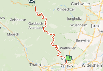
Tocht Wegfiets van 23 km beschikbaar op Grand Est, Haut-Rhin, Cernay. Deze tocht wordt voorgesteld door nadd73.
Beschrijving
Départ de Uffholtz.
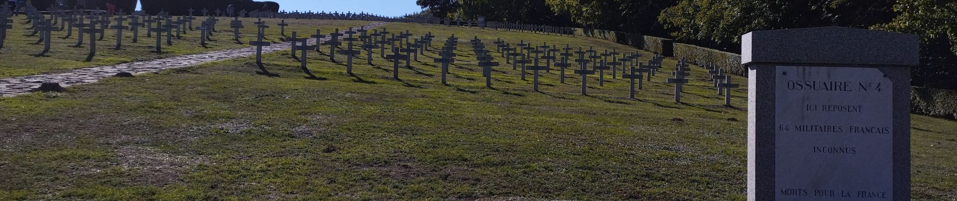
Visite du mémorial de Hatmannswiller
J'ai fait un aller retour.
Donc compter 50km et 1400 de dénivelé.
Plaatsbepaling
Land:
France
Regio :
Grand Est
Departement/Provincie :
Haut-Rhin
Gemeente :
Cernay
Locatie:
Unknown
Vertrek:(Dec)
Vertrek:(UTM)
363220 ; 5296852 (32T) N.
Opmerkingen
Wandeltochten in de omgeving
![Tocht Andere activiteiten Steinbach - lac du ballon - Photo](https://media.geolcdn.com/t/375/260/ext.jpg?maxdim=2&url=https%3A%2F%2Fservices.sitytrail.com%2FGeolivesWS%2FDownloadMedia.ashx%3FTrailID%3D210434%26Media%3Dfix__20130805111422.jpg)
![Andere activiteiten Andere activiteiten](https://static1.geolcdn.com/sitytour/trail-icons/900.png)
lac du ballon
Andere activiteiten
Heel gemakkelijk
(1)
Steinbach,
Grand Est,
Haut-Rhin,
France
![](/images/other/stat-length.png)
33 km | 64 km-effort
5h 1min
![](https://static1.geolcdn.com/siteimages/upload/files/16400158638029165_repeat_loop_refresh_sync_direction_icon.png)
Neen
![Tocht Stappen Steinbach - Cascade de Erzenbach - Photo](https://media.geolcdn.com/t/375/260/069cb34c-c699-4fdf-8c9c-4524251a300c.jpg&format=jpg&maxdim=2)
![Stappen Stappen](https://static1.geolcdn.com/sitytour/trail-icons/101.png)
Cascade de Erzenbach
Stappen
Medium
Steinbach,
Grand Est,
Haut-Rhin,
France
![](/images/other/stat-length.png)
6 km | 8,8 km-effort
1h 32min
![](https://static1.geolcdn.com/siteimages/upload/files/16400158638029165_repeat_loop_refresh_sync_direction_icon.png)
Ja
![Tocht Stappen Uffholtz - Molkenrain 1 - Photo](https://media.geolcdn.com/t/375/260/ext.jpg?maxdim=2&url=https%3A%2F%2Fstatic1.geolcdn.com%2Fsiteimages%2Fupload%2Ffiles%2F1553511878bg_sport_marche.png)
![Stappen Stappen](https://static1.geolcdn.com/sitytour/trail-icons/101.png)
Molkenrain 1
Stappen
Moeilijk
(1)
Uffholtz,
Grand Est,
Haut-Rhin,
France
![](/images/other/stat-length.png)
15,4 km | 26 km-effort
4h 0min
![](https://static1.geolcdn.com/siteimages/upload/files/16400158638029165_repeat_loop_refresh_sync_direction_icon.png)
Ja
![Tocht Stappen Steinbach - Rando CLAS du 02/11/2023 - Photo](https://media.geolcdn.com/t/375/260/b250b3db-11e3-4a80-8674-092c6f8f5747.jpg&format=jpg&maxdim=2)
![Stappen Stappen](https://static1.geolcdn.com/sitytour/trail-icons/101.png)
Rando CLAS du 02/11/2023
Stappen
Zeer moeilijk
Steinbach,
Grand Est,
Haut-Rhin,
France
![](/images/other/stat-length.png)
17,7 km | 27 km-effort
4h 35min
![](https://static1.geolcdn.com/siteimages/upload/files/16400158638029165_repeat_loop_refresh_sync_direction_icon.png)
Ja
![Tocht Stappen Steinbach - Rando Marcheurs du 03/07/2023 par ALAIN - Photo](https://media.geolcdn.com/t/375/260/4e0cdd43-ea09-40bc-a35d-76ad16a35005.jpg&format=jpg&maxdim=2)
![Stappen Stappen](https://static1.geolcdn.com/sitytour/trail-icons/101.png)
Rando Marcheurs du 03/07/2023 par ALAIN
Stappen
Zeer moeilijk
Steinbach,
Grand Est,
Haut-Rhin,
France
![](/images/other/stat-length.png)
20 km | 34 km-effort
5h 1min
![](https://static1.geolcdn.com/siteimages/upload/files/16400158638029165_repeat_loop_refresh_sync_direction_icon.png)
Ja
![Tocht Stappen Wattwiller - Wattwiller - Domaine du Hirtz (30/03/2023) - Photo](https://media.geolcdn.com/t/375/260/fba38f94-41c6-40ad-89c3-14f41fe23918.jpg&format=jpg&maxdim=2)
![Stappen Stappen](https://static1.geolcdn.com/sitytour/trail-icons/101.png)
Wattwiller - Domaine du Hirtz (30/03/2023)
Stappen
Gemakkelijk
Wattwiller,
Grand Est,
Haut-Rhin,
France
![](/images/other/stat-length.png)
6,1 km | 9,9 km-effort
2h 7min
![](https://static1.geolcdn.com/siteimages/upload/files/16400158638029165_repeat_loop_refresh_sync_direction_icon.png)
Ja
![Tocht Stappen Uffholtz - Uffholtz - Wattwiller (23/12/2021) - Photo](https://media.geolcdn.com/t/375/260/02070a0c-7a17-415b-bc7b-c02ebf50cee2.jpg&format=jpg&maxdim=2)
![Stappen Stappen](https://static1.geolcdn.com/sitytour/trail-icons/101.png)
Uffholtz - Wattwiller (23/12/2021)
Stappen
Medium
Uffholtz,
Grand Est,
Haut-Rhin,
France
![](/images/other/stat-length.png)
11,4 km | 17,2 km-effort
3h 27min
![](https://static1.geolcdn.com/siteimages/upload/files/16400158638029165_repeat_loop_refresh_sync_direction_icon.png)
Ja
![Tocht Mountainbike Steinbach - Terrasse de Steinbach - Photo](https://media.geolcdn.com/t/375/260/808ad124-c44a-4a16-9370-b115d7d7eb8d.jpg&format=jpg&maxdim=2)
![Mountainbike Mountainbike](https://static1.geolcdn.com/sitytour/trail-icons/202.png)
Terrasse de Steinbach
Mountainbike
Medium
Steinbach,
Grand Est,
Haut-Rhin,
France
![](/images/other/stat-length.png)
21 km | 30 km-effort
1h 53min
![](https://static1.geolcdn.com/siteimages/upload/files/16400158638029165_repeat_loop_refresh_sync_direction_icon.png)
Ja
![Tocht Stappen Steinbach - steinbach, waldkapelle, vieux thann - Photo](https://media.geolcdn.com/t/375/260/ext.jpg?maxdim=2&url=https%3A%2F%2Fstatic1.geolcdn.com%2Fsiteimages%2Fupload%2Ffiles%2F1553511878bg_sport_marche.png)
![Stappen Stappen](https://static1.geolcdn.com/sitytour/trail-icons/101.png)
steinbach, waldkapelle, vieux thann
Stappen
Gemakkelijk
(1)
Steinbach,
Grand Est,
Haut-Rhin,
France
![](/images/other/stat-length.png)
9 km | 13,4 km-effort
2h 36min
![](https://static1.geolcdn.com/siteimages/upload/files/16400158638029165_repeat_loop_refresh_sync_direction_icon.png)
Ja