![](/images/other/stat-length.png)
![Tocht Elektrische fiets Rostrenen - Ecluse 150(pont de Bonen) Pontivy - Photo](https://media.geolcdn.com/t/1900/400/ext.pjpeg?maxdim=2&url=https%3A%2F%2Fstatic1.geolcdn.com%2Fsiteimages%2Fupload%2Ffiles%2F1524743154velo.jpg)
Ecluse 150(pont de Bonen) Pontivy
plavengut
Gebruiker
![Lengte](/images/other/stat-length.png)
![Max. hoogte](https://static1.geolcdn.com/siteimages/upload/files/1508320355ic_sort_altitude_max_24dp.png)
![Positief hoogteverschil](https://static1.geolcdn.com/siteimages/upload/files/1508320355ic_sort_den_pos_24dp.png)
![Km-Effort](/images/other/stat-length.png)
![Min. hoogte](https://static1.geolcdn.com/siteimages/upload/files/1508320355ic_sort_altitude_min_24dp.png)
![Negatief hoogteverschil](https://static1.geolcdn.com/siteimages/upload/files/1508320355ic_sort_den_neg_24dp.png)
![Boucle](https://static1.geolcdn.com/siteimages/upload/files/16400158638029165_repeat_loop_refresh_sync_direction_icon.png)
![Elektrische fiets](https://static1.geolcdn.com/sitytour/trail-icons/205.png)
4h57
Moeilijkheid : Heel gemakkelijk
![Scan deze QR-code om de tocht te openen in de SityTrail-applicatie](https://capi.geolives.com/qq0zvz2zws4bq2lad0pu/sitytour/trails/3400620/qr.png?size=200)
Gratisgps-wandelapplicatie
Over ons
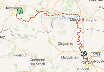
Tocht Elektrische fiets van 58 km beschikbaar op Bretagne, Côtes-d'Armor, Rostrenen. Deze tocht wordt voorgesteld door plavengut.
Beschrijving
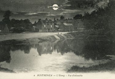
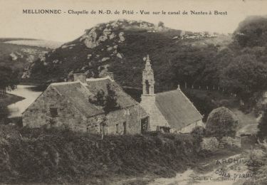
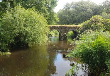
Toujours le long du canal de Nantes à Brest, mais beaucoup moins sauvage. Petite halte à Gouarec, pour voir le village et sa halle, puis quelques km après le magnifique site de l'abbaye de Bon repos (1184)
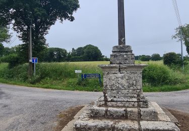
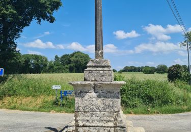
On quitte le canal pour contourner le lac de Guerledan par les hauteurs et une ancienne voie ferrée. Après une pause déjeuner à Saint Aignan on retrouve le canal. Puis petit détour pour aller visiter Notre Dame des Carmes, une pépite inattendue et sa fontaine.
Le soir visite de Pontivy
Plaatsbepaling
Opmerkingen
Wandeltochten in de omgeving
![Tocht Te voet Rostrenen - Du Petit train à la vallée du Doré - Photo](https://media.geolcdn.com/t/375/260/b87bc1d5-32d7-43f7-a8c2-7e2fc825dd0a.jpeg&format=jpg&maxdim=2)
![Te voet Te voet](https://static1.geolcdn.com/sitytour/trail-icons/100.png)
Te voet
![](/images/other/stat-length.png)
![](https://static1.geolcdn.com/siteimages/upload/files/16400158638029165_repeat_loop_refresh_sync_direction_icon.png)
![Tocht Stappen Plouguernével - circuit de la rivière - Photo](https://media.geolcdn.com/t/375/260/63a2a168-701e-4bb3-ad90-823662dec312.jpg&format=jpg&maxdim=2)
![Stappen Stappen](https://static1.geolcdn.com/sitytour/trail-icons/101.png)
Stappen
![](/images/other/stat-length.png)
![](https://static1.geolcdn.com/siteimages/upload/files/16400158638029165_repeat_loop_refresh_sync_direction_icon.png)
![Tocht Te voet Mellionnec - Circuit du Larron - Photo](https://media.geolcdn.com/t/375/260/a67b9e24-0749-41c4-a943-d7647e778a74.jpeg&format=jpg&maxdim=2)
![Te voet Te voet](https://static1.geolcdn.com/sitytour/trail-icons/100.png)
Te voet
![](/images/other/stat-length.png)
![](https://static1.geolcdn.com/siteimages/upload/files/16400158638029165_repeat_loop_refresh_sync_direction_icon.png)
![Tocht Stappen Plouguernével - GR_37_DI_06_Plouguernevel_Glomel_20200621 - Photo](https://media.geolcdn.com/t/375/260/10514163-4b80-40ab-9b4f-c22a490bc0fa.jpg&format=jpg&maxdim=2)
![Stappen Stappen](https://static1.geolcdn.com/sitytour/trail-icons/101.png)
Stappen
![](/images/other/stat-length.png)
![](https://static1.geolcdn.com/siteimages/upload/files/16400158638029165_repeat_loop_refresh_sync_direction_icon.png)
![Tocht Stappen Glomel - La grande tranchée - Photo](https://media.geolcdn.com/t/375/260/c6c877f5-55f2-41dc-a6ee-6016ab77c024.jpg&format=jpg&maxdim=2)
![Stappen Stappen](https://static1.geolcdn.com/sitytour/trail-icons/101.png)
Stappen
![](/images/other/stat-length.png)
![](https://static1.geolcdn.com/siteimages/upload/files/16400158638029165_repeat_loop_refresh_sync_direction_icon.png)
![Tocht Stappen Glomel - Tour de l'etang du Corong depuis Mézouët - Photo](https://media.geolcdn.com/t/375/260/35241bc6-1fc9-430c-a793-ee599ff495df.jpg&format=jpg&maxdim=2)
![Stappen Stappen](https://static1.geolcdn.com/sitytour/trail-icons/101.png)
Stappen
![](/images/other/stat-length.png)
![](https://static1.geolcdn.com/siteimages/upload/files/16400158638029165_repeat_loop_refresh_sync_direction_icon.png)
![Tocht Paardrijden Mellionnec - Mellionnec: boucle Ouest - Photo](https://media.geolcdn.com/t/375/260/ext.jpg?maxdim=2&url=https%3A%2F%2Fstatic1.geolcdn.com%2Fsiteimages%2Fupload%2Ffiles%2F1524743154cheval.jpg)
![Paardrijden Paardrijden](https://static1.geolcdn.com/sitytour/trail-icons/301.png)
Paardrijden
![](/images/other/stat-length.png)
![](https://static1.geolcdn.com/siteimages/upload/files/16400158638029165_repeat_loop_refresh_sync_direction_icon.png)
![Tocht Paardrijden Mellionnec - Mellionnec: tour du Larron - Photo](https://media.geolcdn.com/t/375/260/ext.jpg?maxdim=2&url=https%3A%2F%2Fstatic1.geolcdn.com%2Fsiteimages%2Fupload%2Ffiles%2F1524743154cheval.jpg)
![Paardrijden Paardrijden](https://static1.geolcdn.com/sitytour/trail-icons/301.png)
Paardrijden
![](/images/other/stat-length.png)
![](https://static1.geolcdn.com/siteimages/upload/files/16400158638029165_repeat_loop_refresh_sync_direction_icon.png)
![Tocht Fiets Rostrenen - 5 Rostronen-Gouarec - Photo](https://media.geolcdn.com/t/375/260/ext.jpg?maxdim=2&url=https%3A%2F%2Fstatic1.geolcdn.com%2Fsiteimages%2Fupload%2Ffiles%2F1524743154velo.jpg)
![Fiets Fiets](https://static1.geolcdn.com/sitytour/trail-icons/200.png)
Fiets
![](/images/other/stat-length.png)
![](https://static1.geolcdn.com/siteimages/upload/files/16400158638029165_repeat_loop_refresh_sync_direction_icon.png)