![](/images/other/stat-length.png)
![Tocht Stappen Frévent - FREVENT - Photo](https://media.geolcdn.com/t/1900/400/ext.pjpeg?maxdim=2&url=https%3A%2F%2Fstatic1.geolcdn.com%2Fsiteimages%2Fupload%2Ffiles%2F1553511878bg_sport_marche.png)
FREVENT
dehemjacques
Gebruiker
![Lengte](/images/other/stat-length.png)
Lengte
27 km
![Max. hoogte](https://static1.geolcdn.com/siteimages/upload/files/1508320355ic_sort_altitude_max_24dp.png)
Max. hoogte
149 m
![Positief hoogteverschil](https://static1.geolcdn.com/siteimages/upload/files/1508320355ic_sort_den_pos_24dp.png)
Positief hoogteverschil
285 m
![Km-Effort](/images/other/stat-length.png)
Km-Effort
31 km
![Min. hoogte](https://static1.geolcdn.com/siteimages/upload/files/1508320355ic_sort_altitude_min_24dp.png)
Min. hoogte
53 m
![Negatief hoogteverschil](https://static1.geolcdn.com/siteimages/upload/files/1508320355ic_sort_den_neg_24dp.png)
Negatief hoogteverschil
286 m
![Boucle](https://static1.geolcdn.com/siteimages/upload/files/16400158638029165_repeat_loop_refresh_sync_direction_icon.png)
Boucle
Ja
Datum van aanmaak :
2014-12-10 00:00:00.0
Laatste wijziging :
2014-12-10 00:00:00.0
![Stappen](https://static1.geolcdn.com/sitytour/trail-icons/101.png)
6h42
Moeilijkheid : Medium
![Scan deze QR-code om de tocht te openen in de SityTrail-applicatie](https://capi.geolives.com/qq0zvz2zws4bq2lad0pu/sitytour/trails/338385/qr.png?size=200)
Gratisgps-wandelapplicatie
Over ons
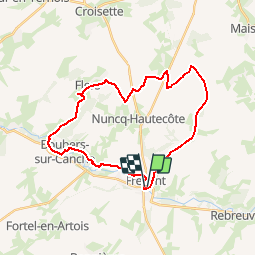
Tocht Stappen van 27 km beschikbaar op Hauts-de-France, Pas-de-Calais, Frévent. Deze tocht wordt voorgesteld door dehemjacques.
Beschrijving
départ par une ancienne voie de chemin de fer jusqu'à petit houvin puis prendre de grp tour du ternois sud jusqu'à enclos annette pour se diriger vers boubers sur canche par le grp tour de la canche-authie
Plaatsbepaling
Land:
France
Regio :
Hauts-de-France
Departement/Provincie :
Pas-de-Calais
Gemeente :
Frévent
Locatie:
Unknown
Vertrek:(Dec)
Vertrek:(UTM)
449658 ; 5569507 (31U) N.
Opmerkingen
Wandeltochten in de omgeving
![Tocht Stappen Boubers-sur-Canche - 7 km autour de Boubers sur Canche - Photo](https://media.geolcdn.com/t/375/260/ext.jpg?maxdim=2&url=https%3A%2F%2Fservices.sitytrail.com%2FGeolivesWS%2FDownloadMedia.ashx%3FTrailID%3D129842%26Media%3D13395_5.jpg)
![Stappen Stappen](https://static1.geolcdn.com/sitytour/trail-icons/101.png)
7 km autour de Boubers sur Canche
Stappen
Gemakkelijk
Boubers-sur-Canche,
Hauts-de-France,
Pas-de-Calais,
France
![](/images/other/stat-length.png)
6,8 km | 7,9 km-effort
1h 40min
![](https://static1.geolcdn.com/siteimages/upload/files/16400158638029165_repeat_loop_refresh_sync_direction_icon.png)
Ja
![Tocht Stappen Ligny-sur-Canche - LIGNY SUR CANCHE - Le fond de Boubers - Photo](https://media.geolcdn.com/t/375/260/4b8325fc-19bd-4d26-8c41-86cfc4b87521.jpg&format=jpg&maxdim=2)
![Stappen Stappen](https://static1.geolcdn.com/sitytour/trail-icons/101.png)
LIGNY SUR CANCHE - Le fond de Boubers
Stappen
Moeilijk
Ligny-sur-Canche,
Hauts-de-France,
Pas-de-Calais,
France
![](/images/other/stat-length.png)
10,7 km | 12,7 km-effort
2h 52min
![](https://static1.geolcdn.com/siteimages/upload/files/16400158638029165_repeat_loop_refresh_sync_direction_icon.png)
Ja
![Tocht Stappen Canettemont - CANETTEMONT (62) Le chemin de Saint Pol - Photo](https://media.geolcdn.com/t/375/260/3a8ebd1b-7f7d-4659-87da-1e3afbf40b0f.jpg&format=jpg&maxdim=2)
![Stappen Stappen](https://static1.geolcdn.com/sitytour/trail-icons/101.png)
CANETTEMONT (62) Le chemin de Saint Pol
Stappen
Medium
Canettemont,
Hauts-de-France,
Pas-de-Calais,
France
![](/images/other/stat-length.png)
8,2 km | 8,9 km-effort
2h 1min
![](https://static1.geolcdn.com/siteimages/upload/files/16400158638029165_repeat_loop_refresh_sync_direction_icon.png)
Ja
![Tocht Stappen Rebreuviette - REBREUVE SUR CANCHE - Les Champs Graux - Photo](https://media.geolcdn.com/t/375/260/52737cb7-11ab-4924-b153-d45a03c268d6.jpg&format=jpg&maxdim=2)
![Stappen Stappen](https://static1.geolcdn.com/sitytour/trail-icons/101.png)
REBREUVE SUR CANCHE - Les Champs Graux
Stappen
Moeilijk
Rebreuviette,
Hauts-de-France,
Pas-de-Calais,
France
![](/images/other/stat-length.png)
11,2 km | 12,6 km-effort
2h 51min
![](https://static1.geolcdn.com/siteimages/upload/files/16400158638029165_repeat_loop_refresh_sync_direction_icon.png)
Ja
![Tocht Te voet Bonnières - BONNIERES (62) - Les éoliennes - Photo](https://media.geolcdn.com/t/375/260/005a97a0-8707-4ea4-9c25-24284e6b14f7.jpg&format=jpg&maxdim=2)
![Te voet Te voet](https://static1.geolcdn.com/sitytour/trail-icons/100.png)
BONNIERES (62) - Les éoliennes
Te voet
Gemakkelijk
Bonnières,
Hauts-de-France,
Pas-de-Calais,
France
![](/images/other/stat-length.png)
15,2 km | 16,9 km-effort
3h 50min
![](https://static1.geolcdn.com/siteimages/upload/files/16400158638029165_repeat_loop_refresh_sync_direction_icon.png)
Ja
![Tocht Andere activiteiten Frévent - Nord - Pas-de-Calais - Ligne 305 - Saint-Roch - Frévent - Photo](https://media.geolcdn.com/t/375/260/ext.jpg?maxdim=2&url=https%3A%2F%2Fstatic1.geolcdn.com%2Fsiteimages%2Fupload%2Ffiles%2F1545311037marcheuse_200dpi.jpg)
![Andere activiteiten Andere activiteiten](https://static1.geolcdn.com/sitytour/trail-icons/900.png)
Nord - Pas-de-Calais - Ligne 305 - Saint-Roch - Frévent
Andere activiteiten
Heel gemakkelijk
Frévent,
Hauts-de-France,
Pas-de-Calais,
France
![](/images/other/stat-length.png)
11 km | 12,4 km-effort
5min
![](https://static1.geolcdn.com/siteimages/upload/files/16400158638029165_repeat_loop_refresh_sync_direction_icon.png)
Neen
![Tocht Stappen Frévent - Rando Frevent 16 km - Photo](https://media.geolcdn.com/t/375/260/ext.jpg?maxdim=2&url=https%3A%2F%2Fstatic1.geolcdn.com%2Fsiteimages%2Fupload%2Ffiles%2F1553511878bg_sport_marche.png)
![Stappen Stappen](https://static1.geolcdn.com/sitytour/trail-icons/101.png)
Rando Frevent 16 km
Stappen
Moeilijk
Frévent,
Hauts-de-France,
Pas-de-Calais,
France
![](/images/other/stat-length.png)
15,9 km | 18,4 km-effort
4h 11min
![](https://static1.geolcdn.com/siteimages/upload/files/16400158638029165_repeat_loop_refresh_sync_direction_icon.png)
Ja
![Tocht Stappen Frévent - Frévent (3) 23.5Kms Dén P 319m - Photo](https://media.geolcdn.com/t/375/260/ext.jpg?maxdim=2&url=https%3A%2F%2Fstatic1.geolcdn.com%2Fsiteimages%2Fupload%2Ffiles%2F1553511878bg_sport_marche.png)
![Stappen Stappen](https://static1.geolcdn.com/sitytour/trail-icons/101.png)
Frévent (3) 23.5Kms Dén P 319m
Stappen
Zeer moeilijk
Frévent,
Hauts-de-France,
Pas-de-Calais,
France
![](/images/other/stat-length.png)
24 km | 28 km-effort
6h 4min
![](https://static1.geolcdn.com/siteimages/upload/files/16400158638029165_repeat_loop_refresh_sync_direction_icon.png)
Ja