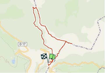
![](/images/other/stat-length.png)
![Tocht Stappen Bethmale - Cap de Bouirex - Photo](https://media.geolcdn.com/t/1900/400/cd5f9d82-9db3-4878-a9ba-18a6e8856ce6.jpg&format=pjpeg&maxdim=2)
Cap de Bouirex
counoise
Gebruiker
![Lengte](/images/other/stat-length.png)
Lengte
8,8 km
![Max. hoogte](https://static1.geolcdn.com/siteimages/upload/files/1508320355ic_sort_altitude_max_24dp.png)
Max. hoogte
1881 m
![Positief hoogteverschil](https://static1.geolcdn.com/siteimages/upload/files/1508320355ic_sort_den_pos_24dp.png)
Positief hoogteverschil
543 m
![Km-Effort](/images/other/stat-length.png)
Km-Effort
16,1 km
![Min. hoogte](https://static1.geolcdn.com/siteimages/upload/files/1508320355ic_sort_altitude_min_24dp.png)
Min. hoogte
1383 m
![Negatief hoogteverschil](https://static1.geolcdn.com/siteimages/upload/files/1508320355ic_sort_den_neg_24dp.png)
Negatief hoogteverschil
545 m
![Boucle](https://static1.geolcdn.com/siteimages/upload/files/16400158638029165_repeat_loop_refresh_sync_direction_icon.png)
Boucle
Ja
Datum van aanmaak :
2022-08-20 09:29:22.132
Laatste wijziging :
2022-08-20 21:11:51.585
![Stappen](https://static1.geolcdn.com/sitytour/trail-icons/101.png)
3h18
Moeilijkheid : Moeilijk
![Scan deze QR-code om de tocht te openen in de SityTrail-applicatie](https://capi.geolives.com/qq0zvz2zws4bq2lad0pu/sitytour/trails/3361714/qr.png?size=200)
Gratisgps-wandelapplicatie
Over ons
Tocht Stappen van 8,8 km beschikbaar op Occitanië, Ariège, Bethmale. Deze tocht wordt voorgesteld door counoise.
Beschrijving
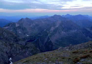
Randonnée à faire dans le sens anti horaire.
Entre le col de la Core et le col du Bas, le sentier n'est pas balisé : suivre les clôtures.
Plaatsbepaling
Land:
France
Regio :
Occitanië
Departement/Provincie :
Ariège
Gemeente :
Bethmale
Locatie:
Unknown
Vertrek:(Dec)
Vertrek:(UTM)
345162 ; 4747002 (31T) N.
Opmerkingen
Wandeltochten in de omgeving
![Tocht Stappen Bethmale - Bethmale - Photo](https://media.geolcdn.com/t/375/260/ext.jpg?maxdim=2&url=https%3A%2F%2Fservices.sitytrail.com%2FGeolivesWS%2FDownloadMedia.ashx%3FTrailID%3D205667%26Media%3Dfix__20130713122146.jpg)
![Stappen Stappen](https://static1.geolcdn.com/sitytour/trail-icons/101.png)
![Tocht Stappen Bethmale - Circuit des cinq étangs (2237m) - Photo](https://media.geolcdn.com/t/375/260/ext.jpg?maxdim=2&url=https%3A%2F%2Fstatic1.geolcdn.com%2Fsiteimages%2Fupload%2Ffiles%2F1553511878bg_sport_marche.png)
![Stappen Stappen](https://static1.geolcdn.com/sitytour/trail-icons/101.png)
Circuit des cinq étangs (2237m)
Stappen
Moeilijk
(3)
Bethmale,
Occitanië,
Ariège,
France
![](/images/other/stat-length.png)
18,1 km | 33 km-effort
Onbekend
![](https://static1.geolcdn.com/siteimages/upload/files/16400158638029165_repeat_loop_refresh_sync_direction_icon.png)
Ja
![Tocht Stappen Seix - 2022 TRANSPYRÉNÉENNE : 6ème etape : Refuge d’Esbints - cabane Aula - Photo](https://media.geolcdn.com/t/375/260/c1446be7-6220-41d3-9aa6-02c934de1eff.jpg&format=jpg&maxdim=2)
![Stappen Stappen](https://static1.geolcdn.com/sitytour/trail-icons/101.png)
2022 TRANSPYRÉNÉENNE : 6ème etape : Refuge d’Esbints - cabane Aula
Stappen
Zeer moeilijk
Seix,
Occitanië,
Ariège,
France
![](/images/other/stat-length.png)
23 km | 38 km-effort
6h 18min
![](https://static1.geolcdn.com/siteimages/upload/files/16400158638029165_repeat_loop_refresh_sync_direction_icon.png)
Neen
![Tocht Stappen Bethmale - Col de la core - Photo](https://media.geolcdn.com/t/375/260/4994e3ec-bda9-4da3-924c-fcb0e68be84a.jpg&format=jpg&maxdim=2)
![Stappen Stappen](https://static1.geolcdn.com/sitytour/trail-icons/101.png)
Col de la core
Stappen
Moeilijk
Bethmale,
Occitanië,
Ariège,
France
![](/images/other/stat-length.png)
15,6 km | 27 km-effort
5h 43min
![](https://static1.geolcdn.com/siteimages/upload/files/16400158638029165_repeat_loop_refresh_sync_direction_icon.png)
Ja
![Tocht Te voet Bethmale - Grand circuit dans la Réserve Naturelle du Mont Valier - Photo](https://media.geolcdn.com/t/375/260/5ad9c477-0f32-4002-9a96-1c99cc53104c.jpeg&format=jpg&maxdim=2)
![Te voet Te voet](https://static1.geolcdn.com/sitytour/trail-icons/100.png)
Grand circuit dans la Réserve Naturelle du Mont Valier
Te voet
Gemakkelijk
Bethmale,
Occitanië,
Ariège,
France
![](/images/other/stat-length.png)
9,5 km | 19,6 km-effort
4h 26min
![](https://static1.geolcdn.com/siteimages/upload/files/16400158638029165_repeat_loop_refresh_sync_direction_icon.png)
Neen
![Tocht Stappen Bethmale - refuge Salvador - Photo](https://media.geolcdn.com/t/375/260/41221468-6f9e-4614-8cc9-9cc4dfd6562d.jpg&format=jpg&maxdim=2)
![Stappen Stappen](https://static1.geolcdn.com/sitytour/trail-icons/101.png)
refuge Salvador
Stappen
Zeer moeilijk
Bethmale,
Occitanië,
Ariège,
France
![](/images/other/stat-length.png)
16 km | 25 km-effort
5h 46min
![](https://static1.geolcdn.com/siteimages/upload/files/16400158638029165_repeat_loop_refresh_sync_direction_icon.png)
Ja
![Tocht Stappen Sentenac-d'Oust - 2020-08-25 col de la cor - col d'Auédole - étang d'Ayes - col d'Auédole - étang d'Eychelle - col de la core. - Photo](https://media.geolcdn.com/t/375/260/1d8e5b8e-ece0-4a83-9c05-d7dab1c422f8.jpg&format=jpg&maxdim=2)
![Stappen Stappen](https://static1.geolcdn.com/sitytour/trail-icons/101.png)
2020-08-25 col de la cor - col d'Auédole - étang d'Ayes - col d'Auédole - éta...
Stappen
Moeilijk
(1)
Sentenac-d'Oust,
Occitanië,
Ariège,
France
![](/images/other/stat-length.png)
11,4 km | 21 km-effort
4h 16min
![](https://static1.geolcdn.com/siteimages/upload/files/16400158638029165_repeat_loop_refresh_sync_direction_icon.png)
Ja
![Tocht Stappen Bethmale - cap de l'auternac en boucle - Photo](https://media.geolcdn.com/t/375/260/ext.jpg?maxdim=2&url=https%3A%2F%2Fservices.sitytrail.com%2FGeolivesWS%2FDownloadMedia.ashx%3FTrailID%3D1076649%26Media%3Dfix__20181121124550.jpg)
![Stappen Stappen](https://static1.geolcdn.com/sitytour/trail-icons/101.png)
cap de l'auternac en boucle
Stappen
Moeilijk
Bethmale,
Occitanië,
Ariège,
France
![](/images/other/stat-length.png)
15 km | 30 km-effort
7h 51min
![](https://static1.geolcdn.com/siteimages/upload/files/16400158638029165_repeat_loop_refresh_sync_direction_icon.png)
Ja
![Tocht Stappen Seix - Cabane d'Aula - Photo](https://media.geolcdn.com/t/375/260/ext.jpg?maxdim=2&url=https%3A%2F%2Fservices.sitytrail.com%2FGeolivesWS%2FDownloadMedia.ashx%3FTrailID%3D834166%26Media%3Dfix__20170824100911.jpg)
![Stappen Stappen](https://static1.geolcdn.com/sitytour/trail-icons/101.png)
Cabane d'Aula
Stappen
Zeer moeilijk
Seix,
Occitanië,
Ariège,
France
![](/images/other/stat-length.png)
18,1 km | 31 km-effort
7h 2min
![](https://static1.geolcdn.com/siteimages/upload/files/16400158638029165_repeat_loop_refresh_sync_direction_icon.png)
Ja