![](/images/other/stat-length.png)
![Tocht Stappen Isola - Cime de Méné - Photo](https://media.geolcdn.com/t/1900/400/ext.pjpeg?maxdim=2&url=https%3A%2F%2Fstatic1.geolcdn.com%2Fsiteimages%2Fupload%2Ffiles%2F1553511878bg_sport_marche.png)
Cime de Méné
bozo1970
Gebruiker
![Lengte](/images/other/stat-length.png)
Lengte
8,8 km
![Max. hoogte](https://static1.geolcdn.com/siteimages/upload/files/1508320355ic_sort_altitude_max_24dp.png)
Max. hoogte
2463 m
![Positief hoogteverschil](https://static1.geolcdn.com/siteimages/upload/files/1508320355ic_sort_den_pos_24dp.png)
Positief hoogteverschil
735 m
![Km-Effort](/images/other/stat-length.png)
Km-Effort
18,6 km
![Min. hoogte](https://static1.geolcdn.com/siteimages/upload/files/1508320355ic_sort_altitude_min_24dp.png)
Min. hoogte
1705 m
![Negatief hoogteverschil](https://static1.geolcdn.com/siteimages/upload/files/1508320355ic_sort_den_neg_24dp.png)
Negatief hoogteverschil
747 m
![Boucle](https://static1.geolcdn.com/siteimages/upload/files/16400158638029165_repeat_loop_refresh_sync_direction_icon.png)
Boucle
Ja
Datum van aanmaak :
2022-08-16 07:16:56.0
Laatste wijziging :
2022-08-17 08:11:09.71
![Stappen](https://static1.geolcdn.com/sitytour/trail-icons/101.png)
3h11
Moeilijkheid : Gemakkelijk
![Scan deze QR-code om de tocht te openen in de SityTrail-applicatie](https://capi.geolives.com/qq0zvz2zws4bq2lad0pu/sitytour/trails/3356568/qr.png?size=200)
Gratisgps-wandelapplicatie
Over ons
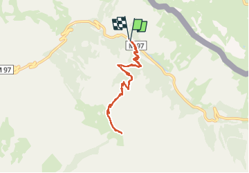
Tocht Stappen van 8,8 km beschikbaar op Provence-Alpes-Côte d'Azur, Alpes-Maritimes, Isola. Deze tocht wordt voorgesteld door bozo1970.
Beschrijving
Départ balise 76
Agréable en sous bois
1h30’ jusqu’à la crête
1h45’ au sommet
D 750 9km
3h11’ A/R
Plaatsbepaling
Land:
France
Regio :
Provence-Alpes-Côte d'Azur
Departement/Provincie :
Alpes-Maritimes
Gemeente :
Isola
Locatie:
Unknown
Vertrek:(Dec)
Vertrek:(UTM)
349394 ; 4896478 (32T) N.
Opmerkingen
Wandeltochten in de omgeving
![Tocht Stappen Isola - Châtaigneraie ISOLA - Photo](https://media.geolcdn.com/t/375/260/ext.jpg?maxdim=2&url=https%3A%2F%2Fservices.sitytrail.com%2FGeolivesWS%2FDownloadMedia.ashx%3FTrailID%3D470503%26Media%3D20150910120215.jpg)
![Stappen Stappen](https://static1.geolcdn.com/sitytour/trail-icons/101.png)
Châtaigneraie ISOLA
Stappen
Heel gemakkelijk
(1)
Isola,
Provence-Alpes-Côte d'Azur,
Alpes-Maritimes,
France
![](/images/other/stat-length.png)
4,4 km | 7,1 km-effort
2h 9min
![](https://static1.geolcdn.com/siteimages/upload/files/16400158638029165_repeat_loop_refresh_sync_direction_icon.png)
Ja
![Tocht Andere activiteiten Isola - Isola 2000 baisse Druos refuge Quesa - Photo](https://media.geolcdn.com/t/375/260/ext.jpg?maxdim=2&url=https%3A%2F%2Fservices.sitytrail.com%2FGeolivesWS%2FDownloadMedia.ashx%3FTrailID%3D631831%26Media%3Dfix__20160806152443.jpg)
![Andere activiteiten Andere activiteiten](https://static1.geolcdn.com/sitytour/trail-icons/900.png)
Isola 2000 baisse Druos refuge Quesa
Andere activiteiten
Heel gemakkelijk
(1)
Isola,
Provence-Alpes-Côte d'Azur,
Alpes-Maritimes,
France
![](/images/other/stat-length.png)
21 km | 35 km-effort
8h 5min
![](https://static1.geolcdn.com/siteimages/upload/files/16400158638029165_repeat_loop_refresh_sync_direction_icon.png)
Ja
![Tocht Stappen Isola - Tête Mercière et Lacs de terre rouge 24.8.24 - Photo](https://media.geolcdn.com/t/375/260/3e3a1aaf-e381-4ca9-a18c-df28b1091979.jpg&format=jpg&maxdim=2)
![Stappen Stappen](https://static1.geolcdn.com/sitytour/trail-icons/101.png)
Tête Mercière et Lacs de terre rouge 24.8.24
Stappen
Medium
Isola,
Provence-Alpes-Côte d'Azur,
Alpes-Maritimes,
France
![](/images/other/stat-length.png)
11,6 km | 18 km-effort
4h 0min
![](https://static1.geolcdn.com/siteimages/upload/files/16400158638029165_repeat_loop_refresh_sync_direction_icon.png)
Neen
![Tocht Te voet Isola - Tête Mercière - Photo](https://media.geolcdn.com/t/375/260/8e1ca2e5-a446-45a1-b4b9-1747f6caafe0.jpeg&format=jpg&maxdim=2)
![Te voet Te voet](https://static1.geolcdn.com/sitytour/trail-icons/100.png)
Tête Mercière
Te voet
Gemakkelijk
Isola,
Provence-Alpes-Côte d'Azur,
Alpes-Maritimes,
France
![](/images/other/stat-length.png)
8,1 km | 14,8 km-effort
3h 21min
![](https://static1.geolcdn.com/siteimages/upload/files/16400158638029165_repeat_loop_refresh_sync_direction_icon.png)
Neen
![Tocht Te voet Vinadio - Tour du Lausfer - Photo](https://media.geolcdn.com/t/375/260/cc4c2b4d-e173-4a84-be7d-4686c9701dd6.jpeg&format=jpg&maxdim=2)
![Te voet Te voet](https://static1.geolcdn.com/sitytour/trail-icons/100.png)
Tour du Lausfer
Te voet
Gemakkelijk
Vinadio,
Piëmont,
Cuneo,
Italy
![](/images/other/stat-length.png)
9,5 km | 16,7 km-effort
3h 47min
![](https://static1.geolcdn.com/siteimages/upload/files/16400158638029165_repeat_loop_refresh_sync_direction_icon.png)
Ja
![Tocht Te voet Vinadio - (SI E13) Sant'Anna di Vinadio - Vinadio Frazione Strepeis - Photo](https://media.geolcdn.com/t/375/260/2964e30b-263b-42c3-aa1c-ecaafebd0df1.jpeg&format=jpg&maxdim=2)
![Te voet Te voet](https://static1.geolcdn.com/sitytour/trail-icons/100.png)
(SI E13) Sant'Anna di Vinadio - Vinadio Frazione Strepeis
Te voet
Gemakkelijk
Vinadio,
Piëmont,
Cuneo,
Italy
![](/images/other/stat-length.png)
9,1 km | 16,1 km-effort
3h 40min
![](https://static1.geolcdn.com/siteimages/upload/files/16400158638029165_repeat_loop_refresh_sync_direction_icon.png)
Neen
![Tocht Stappen Isola - cime de la lombarde - Photo](https://media.geolcdn.com/t/375/260/ext.jpg?maxdim=2&url=https%3A%2F%2Fstatic1.geolcdn.com%2Fsiteimages%2Fupload%2Ffiles%2F1553511878bg_sport_marche.png)
![Stappen Stappen](https://static1.geolcdn.com/sitytour/trail-icons/101.png)
cime de la lombarde
Stappen
Zeer moeilijk
(1)
Isola,
Provence-Alpes-Côte d'Azur,
Alpes-Maritimes,
France
![](/images/other/stat-length.png)
16,7 km | 31 km-effort
9h 25min
![](https://static1.geolcdn.com/siteimages/upload/files/16400158638029165_repeat_loop_refresh_sync_direction_icon.png)
Ja
![Tocht Stappen Vinadio - Cime de la Lombarde 2800m 26.8.24 - Photo](https://media.geolcdn.com/t/375/260/a90fbc15-b832-4be5-b4ba-c6dcb34efb02.jpg&format=jpg&maxdim=2)
![Stappen Stappen](https://static1.geolcdn.com/sitytour/trail-icons/101.png)
Cime de la Lombarde 2800m 26.8.24
Stappen
Zeer moeilijk
Vinadio,
Piëmont,
Cuneo,
Italy
![](/images/other/stat-length.png)
3,4 km | 9,1 km-effort
2h 30min
![](https://static1.geolcdn.com/siteimages/upload/files/16400158638029165_repeat_loop_refresh_sync_direction_icon.png)
Ja
![Tocht Stappen Vinadio - Tour du Lausfer 25.8.24 - Photo](https://media.geolcdn.com/t/375/260/72863bea-5e16-4036-8653-9180a45481ca.jpg&format=jpg&maxdim=2)
![Stappen Stappen](https://static1.geolcdn.com/sitytour/trail-icons/101.png)
Tour du Lausfer 25.8.24
Stappen
Medium
Vinadio,
Piëmont,
Cuneo,
Italy
![](/images/other/stat-length.png)
9 km | 16,2 km-effort
3h 30min
![](https://static1.geolcdn.com/siteimages/upload/files/16400158638029165_repeat_loop_refresh_sync_direction_icon.png)
Ja