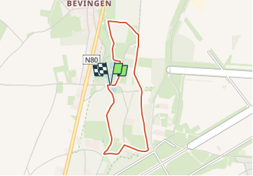
![](/images/other/stat-length.png)
![Tocht Stappen Sint-Truiden - La vallée du ruisseau Cicindria à Saint-Trond (petite) - Photo](https://media.geolcdn.com/t/1900/400/fb59e6e8-e19f-409b-83a1-d662f2e9ddcb.jpg&format=pjpeg&maxdim=2)
La vallée du ruisseau Cicindria à Saint-Trond (petite)
Benjamin27
Gebruiker GUIDE
![Lengte](/images/other/stat-length.png)
![Max. hoogte](https://static1.geolcdn.com/siteimages/upload/files/1508320355ic_sort_altitude_max_24dp.png)
![Positief hoogteverschil](https://static1.geolcdn.com/siteimages/upload/files/1508320355ic_sort_den_pos_24dp.png)
![Km-Effort](/images/other/stat-length.png)
![Min. hoogte](https://static1.geolcdn.com/siteimages/upload/files/1508320355ic_sort_altitude_min_24dp.png)
![Negatief hoogteverschil](https://static1.geolcdn.com/siteimages/upload/files/1508320355ic_sort_den_neg_24dp.png)
![Boucle](https://static1.geolcdn.com/siteimages/upload/files/16400158638029165_repeat_loop_refresh_sync_direction_icon.png)
![Stappen](https://static1.geolcdn.com/sitytour/trail-icons/101.png)
47m
Moeilijkheid : Gemakkelijk
![Scan deze QR-code om de tocht te openen in de SityTrail-applicatie](https://capi.geolives.com/qq0zvz2zws4bq2lad0pu/sitytour/trails/3350287/qr.png?size=200)
Gratisgps-wandelapplicatie
Over ons
Tocht Stappen van 3,1 km beschikbaar op Vlaanderen, Limburg, Sint-Truiden. Deze tocht wordt voorgesteld door Benjamin27.
Beschrijving
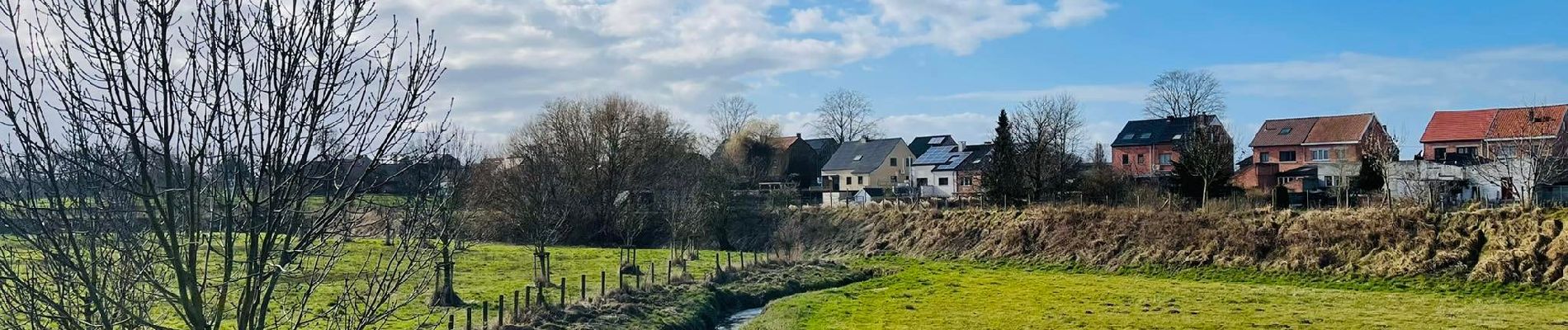
Dans cette vallée, vous aurez un panorama complet des paysages typiques de la Hesbaye. Longez ce magnifique ruisseau et aventurez-vous entre champs et vergers.
👣 Distance : 2,9km - balisage rectangle vert.
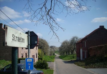
📍Départ : parking prévu à Straeten, 3800 Saint-Trond.
🚂🚍 Aller à la gare de Landen et prendre le bus DE LIJN 42 jusqu’à l’arrêt « Bevingen - Straeten ».
Plaatsbepaling
Opmerkingen
Wandeltochten in de omgeving
![Tocht Stappen Sint-Truiden - Aalst Dorp - Photo](https://media.geolcdn.com/t/375/260/ext.jpg?maxdim=2&url=https%3A%2F%2Fservices.sitytrail.com%2FGeolivesWS%2FDownloadMedia.ashx%3FTrailID%3D238221%26Media%3Dfix__20131125132034.jpg)
![Stappen Stappen](https://static1.geolcdn.com/sitytour/trail-icons/101.png)
Stappen
![](/images/other/stat-length.png)
![](https://static1.geolcdn.com/siteimages/upload/files/16400158638029165_repeat_loop_refresh_sync_direction_icon.png)
![Tocht Te voet Sint-Truiden - Bernissem wandeling - Photo](https://media.geolcdn.com/t/375/260/da47f886-95ef-4a45-a44c-87cd8463dff7.jpeg&format=jpg&maxdim=2)
![Te voet Te voet](https://static1.geolcdn.com/sitytour/trail-icons/100.png)
Te voet
![](/images/other/stat-length.png)
![](https://static1.geolcdn.com/siteimages/upload/files/16400158638029165_repeat_loop_refresh_sync_direction_icon.png)
![Tocht Te voet Sint-Truiden - Cicindria Kerkom blauwe ruit - Photo](https://media.geolcdn.com/t/375/260/06861b0c-4bb0-4416-ae39-787d2bf09bca.jpeg&format=jpg&maxdim=2)
![Te voet Te voet](https://static1.geolcdn.com/sitytour/trail-icons/100.png)
Te voet
![](/images/other/stat-length.png)
![](https://static1.geolcdn.com/siteimages/upload/files/16400158638029165_repeat_loop_refresh_sync_direction_icon.png)
![Tocht Te voet Sint-Truiden - Cicindria Straeten oranje bol - Photo](https://media.geolcdn.com/t/375/260/6d7e87b3-3f7e-4b4a-bf60-733308598a38.jpeg&format=jpg&maxdim=2)
![Te voet Te voet](https://static1.geolcdn.com/sitytour/trail-icons/100.png)
Te voet
![](/images/other/stat-length.png)
![](https://static1.geolcdn.com/siteimages/upload/files/16400158638029165_repeat_loop_refresh_sync_direction_icon.png)
![Tocht Te voet Sint-Truiden - Cicindria Straeten groene rechthoek - Photo](https://media.geolcdn.com/t/375/260/6d7e87b3-3f7e-4b4a-bf60-733308598a38.jpeg&format=jpg&maxdim=2)
![Te voet Te voet](https://static1.geolcdn.com/sitytour/trail-icons/100.png)
Te voet
![](/images/other/stat-length.png)
![](https://static1.geolcdn.com/siteimages/upload/files/16400158638029165_repeat_loop_refresh_sync_direction_icon.png)
![Tocht Te voet Sint-Truiden - Staaien rode driehoek - Photo](https://media.geolcdn.com/t/375/260/cd3d1f60-3cd2-4539-a2b4-06ec7df817c9.jpeg&format=jpg&maxdim=2)
![Te voet Te voet](https://static1.geolcdn.com/sitytour/trail-icons/100.png)
Te voet
![](/images/other/stat-length.png)
![](https://static1.geolcdn.com/siteimages/upload/files/16400158638029165_repeat_loop_refresh_sync_direction_icon.png)
![Tocht Te voet Sint-Truiden - Staaien oranje bol - Photo](https://media.geolcdn.com/t/375/260/7b137b54-411c-4e68-8c6c-aeb3fad0dd86.jpeg&format=jpg&maxdim=2)
![Te voet Te voet](https://static1.geolcdn.com/sitytour/trail-icons/100.png)
Te voet
![](/images/other/stat-length.png)
![](https://static1.geolcdn.com/siteimages/upload/files/16400158638029165_repeat_loop_refresh_sync_direction_icon.png)
![Tocht Stappen Sint-Truiden - La petite église de Guvelingen à Saint-Trond - Photo](https://media.geolcdn.com/t/375/260/2dfbb9e1-f6fd-446e-ac63-6ef5fef7f407.jpeg&format=jpg&maxdim=2)
![Stappen Stappen](https://static1.geolcdn.com/sitytour/trail-icons/101.png)
Stappen
![](/images/other/stat-length.png)
![](https://static1.geolcdn.com/siteimages/upload/files/16400158638029165_repeat_loop_refresh_sync_direction_icon.png)
![Tocht Stappen Sint-Truiden - La vallée fruitière à Saint-Trond - Photo](https://media.geolcdn.com/t/375/260/1eb5917c-9ec1-4729-bf31-3ca14ced1caa.jpg&format=jpg&maxdim=2)
![Stappen Stappen](https://static1.geolcdn.com/sitytour/trail-icons/101.png)
Stappen
![](/images/other/stat-length.png)
![](https://static1.geolcdn.com/siteimages/upload/files/16400158638029165_repeat_loop_refresh_sync_direction_icon.png)