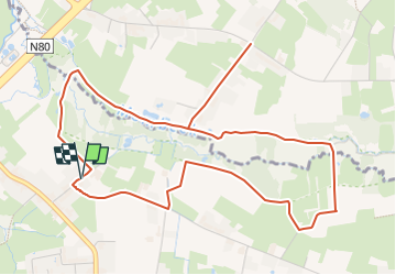
![](/images/other/stat-length.png)
![Tocht Stappen Alken - La vallée du ruisseau Mombeek à Alken - Photo](https://media.geolcdn.com/t/1900/400/37eadaf1-02f9-4a3d-a07c-c4b016c2089e.jpg&format=pjpeg&maxdim=2)
La vallée du ruisseau Mombeek à Alken
Benjamin27
Gebruiker GUIDE
![Lengte](/images/other/stat-length.png)
![Max. hoogte](https://static1.geolcdn.com/siteimages/upload/files/1508320355ic_sort_altitude_max_24dp.png)
![Positief hoogteverschil](https://static1.geolcdn.com/siteimages/upload/files/1508320355ic_sort_den_pos_24dp.png)
![Km-Effort](/images/other/stat-length.png)
![Min. hoogte](https://static1.geolcdn.com/siteimages/upload/files/1508320355ic_sort_altitude_min_24dp.png)
![Negatief hoogteverschil](https://static1.geolcdn.com/siteimages/upload/files/1508320355ic_sort_den_neg_24dp.png)
![Boucle](https://static1.geolcdn.com/siteimages/upload/files/16400158638029165_repeat_loop_refresh_sync_direction_icon.png)
![Stappen](https://static1.geolcdn.com/sitytour/trail-icons/101.png)
1h28
Moeilijkheid : Medium
![Scan deze QR-code om de tocht te openen in de SityTrail-applicatie](https://capi.geolives.com/qq0zvz2zws4bq2lad0pu/sitytour/trails/3350285/qr.png?size=200)
Gratisgps-wandelapplicatie
Over ons
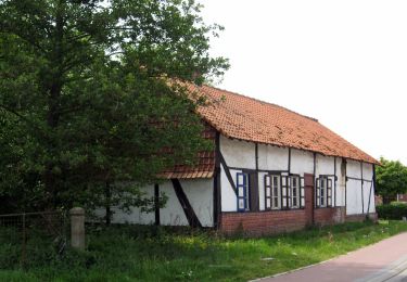
Tocht Stappen van 5,8 km beschikbaar op Vlaanderen, Limburg, Alken. Deze tocht wordt voorgesteld door Benjamin27.
Beschrijving
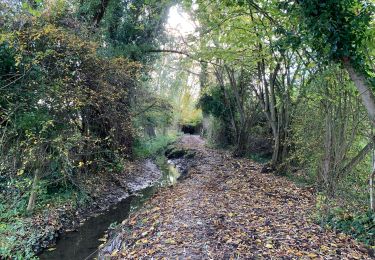
Le long du ruisseau, vous rencontrerez de jolis bois, d’agréables terrains marécageux à parcourir sur caillebotis et, si vous avez de la chance, vous apercevrez de magnifiques animaux qui viendront, à distance, vous dire bonjour.
👣 Distance : 6km - balisage flèche rouge.
📍Départ : muntelbeekstraat 1 à 3500 Hasselt.
🚂🚍 Aller à la gare de Hasselt et prendre le bus DE LIJN H71 jusqu’à l’arrêt « Hasselt - Muntelbeekstraat ».
Plaatsbepaling
Opmerkingen
Wandeltochten in de omgeving
![Tocht Te voet Hasselt - Mombeekvallei Rode pijl (vanuit Sint-Lambrechts-Herk) - Photo](https://media.geolcdn.com/t/375/260/c19127bd-cbbf-45c8-9b57-70604adcc44c.jpeg&format=jpg&maxdim=2)
![Te voet Te voet](https://static1.geolcdn.com/sitytour/trail-icons/100.png)
Te voet
![](/images/other/stat-length.png)
![](https://static1.geolcdn.com/siteimages/upload/files/16400158638029165_repeat_loop_refresh_sync_direction_icon.png)
![Tocht Te voet Wellen - Alken-Wellen verbinding - Photo](https://media.geolcdn.com/t/375/260/3e82e838-81f6-4f4d-83f3-4708a8447d05.jpeg&format=jpg&maxdim=2)
![Te voet Te voet](https://static1.geolcdn.com/sitytour/trail-icons/100.png)
Te voet
![](/images/other/stat-length.png)
![](https://static1.geolcdn.com/siteimages/upload/files/16400158638029165_repeat_loop_refresh_sync_direction_icon.png)
![Tocht Te voet Hasselt - Mombeekpad W700 geel - Photo](https://media.geolcdn.com/t/375/260/d91aeff8-4d52-4b35-a08b-6ff9055d6a9b.jpeg&format=jpg&maxdim=2)
![Te voet Te voet](https://static1.geolcdn.com/sitytour/trail-icons/100.png)
Te voet
![](/images/other/stat-length.png)
![](https://static1.geolcdn.com/siteimages/upload/files/16400158638029165_repeat_loop_refresh_sync_direction_icon.png)
![Tocht Te voet Hasselt - Grenspad W700 groen - Photo](https://media.geolcdn.com/t/375/260/a249397e-a5bf-4478-b685-36c36b1d5139.jpeg&format=jpg&maxdim=2)
![Te voet Te voet](https://static1.geolcdn.com/sitytour/trail-icons/100.png)
Te voet
![](/images/other/stat-length.png)
![](https://static1.geolcdn.com/siteimages/upload/files/16400158638029165_repeat_loop_refresh_sync_direction_icon.png)
![Tocht Te voet Alken - Mombeekvallei Rode pijl (vanuit Alken) - Photo](https://media.geolcdn.com/t/375/260/a7d8db3d-2688-4705-a78c-05946b0d29f0.jpeg&format=jpg&maxdim=2)
![Te voet Te voet](https://static1.geolcdn.com/sitytour/trail-icons/100.png)
Te voet
![](/images/other/stat-length.png)
![](https://static1.geolcdn.com/siteimages/upload/files/16400158638029165_repeat_loop_refresh_sync_direction_icon.png)
![Tocht Te voet Hasselt - Mombeekvallei Geel - Photo](https://media.geolcdn.com/t/375/260/1564a310-bc78-4cc9-b58d-5e56e18c6483.jpeg&format=jpg&maxdim=2)
![Te voet Te voet](https://static1.geolcdn.com/sitytour/trail-icons/100.png)
Te voet
![](/images/other/stat-length.png)
![](https://static1.geolcdn.com/siteimages/upload/files/16400158638029165_repeat_loop_refresh_sync_direction_icon.png)
![Tocht Te voet Diepenbeek - Nietelbroeken - Photo](https://media.geolcdn.com/t/375/260/7541b859-d97b-4d1a-892d-184d3aaca5b8.jpeg&format=jpg&maxdim=2)
![Te voet Te voet](https://static1.geolcdn.com/sitytour/trail-icons/100.png)
Te voet
![](/images/other/stat-length.png)
![](https://static1.geolcdn.com/siteimages/upload/files/16400158638029165_repeat_loop_refresh_sync_direction_icon.png)
![Tocht Stappen Kortessem - Le bois Bellevue à Kortessem - Photo](https://media.geolcdn.com/t/375/260/5f642756-3013-4d97-ba18-8fae43cebfc7.jpeg&format=jpg&maxdim=2)
![Stappen Stappen](https://static1.geolcdn.com/sitytour/trail-icons/101.png)
Stappen
![](/images/other/stat-length.png)
![](https://static1.geolcdn.com/siteimages/upload/files/16400158638029165_repeat_loop_refresh_sync_direction_icon.png)
![Tocht Stappen Diepenbeek - La réserve naturelle Nietelbroeken à Kortessem - Photo](https://media.geolcdn.com/t/375/260/feb436bf-26a9-4a84-b1fa-04fcda8330b1.jpeg&format=jpg&maxdim=2)
![Stappen Stappen](https://static1.geolcdn.com/sitytour/trail-icons/101.png)
Stappen
![](/images/other/stat-length.png)
![](https://static1.geolcdn.com/siteimages/upload/files/16400158638029165_repeat_loop_refresh_sync_direction_icon.png)