![](/images/other/stat-length.png)
![Tocht Elektrische fiets Tubeke - Au fil de la Senne et bois de la Houssière - Photo](https://media.geolcdn.com/t/1900/400/ext.pjpeg?maxdim=2&url=https%3A%2F%2Fstatic1.geolcdn.com%2Fsiteimages%2Fupload%2Ffiles%2F1524743154velo.jpg)
Au fil de la Senne et bois de la Houssière
Boubby
Gebruiker
![Lengte](/images/other/stat-length.png)
Lengte
39 km
![Max. hoogte](https://static1.geolcdn.com/siteimages/upload/files/1508320355ic_sort_altitude_max_24dp.png)
Max. hoogte
146 m
![Positief hoogteverschil](https://static1.geolcdn.com/siteimages/upload/files/1508320355ic_sort_den_pos_24dp.png)
Positief hoogteverschil
446 m
![Km-Effort](/images/other/stat-length.png)
Km-Effort
45 km
![Min. hoogte](https://static1.geolcdn.com/siteimages/upload/files/1508320355ic_sort_altitude_min_24dp.png)
Min. hoogte
35 m
![Negatief hoogteverschil](https://static1.geolcdn.com/siteimages/upload/files/1508320355ic_sort_den_neg_24dp.png)
Negatief hoogteverschil
448 m
![Boucle](https://static1.geolcdn.com/siteimages/upload/files/16400158638029165_repeat_loop_refresh_sync_direction_icon.png)
Boucle
Ja
Datum van aanmaak :
2022-08-07 15:29:19.0
Laatste wijziging :
2022-08-07 15:29:20.298
![Elektrische fiets](https://static1.geolcdn.com/sitytour/trail-icons/205.png)
3h00
Moeilijkheid : Gemakkelijk
![Scan deze QR-code om de tocht te openen in de SityTrail-applicatie](https://capi.geolives.com/qq0zvz2zws4bq2lad0pu/sitytour/trails/3346216/qr.png?size=200)
Gratisgps-wandelapplicatie
Over ons
Tocht Elektrische fiets van 39 km beschikbaar op Wallonië, Waals-Brabant, Tubeke. Deze tocht wordt voorgesteld door Boubby.
Beschrijving
Balade bucolique en boucle améliorée le long de la Senne via la réserve du Paradis et en revenant par le bois de la Houssière et les étangs de Couercq
Plaatsbepaling
Land:
Belgium
Regio :
Wallonië
Departement/Provincie :
Waals-Brabant
Gemeente :
Tubeke
Locatie:
Tubeke
Vertrek:(Dec)
Vertrek:(UTM)
584016 ; 5616461 (31U) N.
Opmerkingen
Wandeltochten in de omgeving
![Tocht Stappen Rebecq - RB-BW-15-raccourci 1 - Flânerie entre Senne et Coeurcq - Photo](https://media.geolcdn.com/t/375/260/ext.jpg?maxdim=2&url=https%3A%2F%2Fservices.sitytrail.com%2FGeolivesWS%2FDownloadMedia.ashx%3FTrailID%3D221651%26Media%3D1bf86fcb-c1a5-4116-8d1a-312b51935dfd.jpg)
![Stappen Stappen](https://static1.geolcdn.com/sitytour/trail-icons/101.png)
RB-BW-15-raccourci 1 - Flânerie entre Senne et Coeurcq
Stappen
Moeilijk
(2)
Rebecq,
Wallonië,
Waals-Brabant,
Belgium
![](/images/other/stat-length.png)
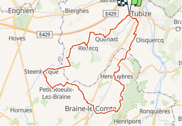
13,2 km | 15,9 km-effort
3h 36min
![](https://static1.geolcdn.com/siteimages/upload/files/16400158638029165_repeat_loop_refresh_sync_direction_icon.png)
Ja
![Tocht Stappen Rebecq - RB-Bw-15_Rebecq - Photo](https://media.geolcdn.com/t/375/260/ext.jpg?maxdim=2&url=https%3A%2F%2Fservices.sitytrail.com%2FGeolivesWS%2FDownloadMedia.ashx%3FTrailID%3D179590%26Media%3D1bf86fcb-c1a5-4116-8d1a-312b51935dfd.jpg)
![Stappen Stappen](https://static1.geolcdn.com/sitytour/trail-icons/101.png)
RB-Bw-15_Rebecq
Stappen
Gemakkelijk
(3)
Rebecq,
Wallonië,
Waals-Brabant,
Belgium
![](/images/other/stat-length.png)
24 km | 29 km-effort
6h 9min
![](https://static1.geolcdn.com/siteimages/upload/files/16400158638029165_repeat_loop_refresh_sync_direction_icon.png)
Ja
![Tocht Stappen 's-Gravenbrakel - GG2-Bw-23_Hennuyères-Nivelles-provisoire_2021-11-07 - Photo](https://media.geolcdn.com/t/375/260/ext.jpg?maxdim=2&url=https%3A%2F%2Fmedia.geolcdn.com%2Ff%2F1dada4ae-333c-49ef-bd66-7a7470a12297.JPG)
![Stappen Stappen](https://static1.geolcdn.com/sitytour/trail-icons/101.png)
GG2-Bw-23_Hennuyères-Nivelles-provisoire_2021-11-07
Stappen
Zeer moeilijk
(2)
's-Gravenbrakel,
Wallonië,
Henegouwen,
Belgium
![](/images/other/stat-length.png)
25 km | 29 km-effort
6h 39min
![](https://static1.geolcdn.com/siteimages/upload/files/16400158638029165_repeat_loop_refresh_sync_direction_icon.png)
Neen
![Tocht Stappen Tubeke - Balade à Tubize - Photo](https://media.geolcdn.com/t/375/260/ext.jpg?maxdim=2&url=https%3A%2F%2Fmedia.geolcdn.com%2Ff%2F69d74dbc-0628-4bb4-9bfb-952693a1a5ea.jpeg)
![Stappen Stappen](https://static1.geolcdn.com/sitytour/trail-icons/101.png)
Balade à Tubize
Stappen
Medium
Tubeke,
Wallonië,
Waals-Brabant,
Belgium
![](/images/other/stat-length.png)
8,4 km | 9,7 km-effort
2h 11min
![](https://static1.geolcdn.com/siteimages/upload/files/16400158638029165_repeat_loop_refresh_sync_direction_icon.png)
Ja
![Tocht Stappen Tubeke - Oisquercq 15 km test gps - Photo](https://media.geolcdn.com/t/375/260/ext.jpg?maxdim=2&url=https%3A%2F%2Fmedia.geolcdn.com%2Ff%2F423b53fa-ccac-4491-aaf0-8af44d37d802.jpg)
![Stappen Stappen](https://static1.geolcdn.com/sitytour/trail-icons/101.png)
Oisquercq 15 km test gps
Stappen
Medium
Tubeke,
Wallonië,
Waals-Brabant,
Belgium
![](/images/other/stat-length.png)
15,7 km | 19,3 km-effort
3h 35min
![](https://static1.geolcdn.com/siteimages/upload/files/16400158638029165_repeat_loop_refresh_sync_direction_icon.png)
Ja
![Tocht Stappen Tubeke - rass 20 kms 2019 - Photo](https://media.geolcdn.com/t/375/260/ext.jpg?maxdim=2&url=https%3A%2F%2Fstatic1.geolcdn.com%2Fsiteimages%2Fupload%2Ffiles%2F1553511878bg_sport_marche.png)
![Stappen Stappen](https://static1.geolcdn.com/sitytour/trail-icons/101.png)
rass 20 kms 2019
Stappen
Zeer moeilijk
(1)
Tubeke,
Wallonië,
Waals-Brabant,
Belgium
![](/images/other/stat-length.png)
18,6 km | 21 km-effort
4h 39min
![](https://static1.geolcdn.com/siteimages/upload/files/16400158638029165_repeat_loop_refresh_sync_direction_icon.png)
Ja
![Tocht Stappen Tubeke - rass 10 kms 2019 - Photo](https://media.geolcdn.com/t/375/260/ext.jpg?maxdim=2&url=https%3A%2F%2Fstatic1.geolcdn.com%2Fsiteimages%2Fupload%2Ffiles%2F1553511878bg_sport_marche.png)
![Stappen Stappen](https://static1.geolcdn.com/sitytour/trail-icons/101.png)
rass 10 kms 2019
Stappen
Medium
(1)
Tubeke,
Wallonië,
Waals-Brabant,
Belgium
![](/images/other/stat-length.png)
9,5 km | 10,9 km-effort
2h 23min
![](https://static1.geolcdn.com/siteimages/upload/files/16400158638029165_repeat_loop_refresh_sync_direction_icon.png)
Ja
![Tocht Stappen Tubeke - Tubize à Coeurcq 1117 - Photo](https://media.geolcdn.com/t/375/260/ext.jpg?maxdim=2&url=https%3A%2F%2Fstatic1.geolcdn.com%2Fsiteimages%2Fupload%2Ffiles%2F1553511878bg_sport_marche.png)
![Stappen Stappen](https://static1.geolcdn.com/sitytour/trail-icons/101.png)
Tubize à Coeurcq 1117
Stappen
Gemakkelijk
(2)
Tubeke,
Wallonië,
Waals-Brabant,
Belgium
![](/images/other/stat-length.png)
9,9 km | 11,7 km-effort
2h 34min
![](https://static1.geolcdn.com/siteimages/upload/files/16400158638029165_repeat_loop_refresh_sync_direction_icon.png)
Ja
![Tocht Stappen Itter - virginal 0717 - Photo](https://media.geolcdn.com/t/375/260/ext.jpg?maxdim=2&url=https%3A%2F%2Fstatic1.geolcdn.com%2Fsiteimages%2Fupload%2Ffiles%2F1553511878bg_sport_marche.png)
![Stappen Stappen](https://static1.geolcdn.com/sitytour/trail-icons/101.png)
virginal 0717
Stappen
Gemakkelijk
(1)
Itter,
Wallonië,
Waals-Brabant,
Belgium
![](/images/other/stat-length.png)
6,1 km | 7,5 km-effort
1h 39min
![](https://static1.geolcdn.com/siteimages/upload/files/16400158638029165_repeat_loop_refresh_sync_direction_icon.png)
Ja