Tocht Te voet Saint-Christophe - Voie-Sarde - Photo

Une équipe à votre service garant de convivialité et bonne humeur

© OpenStreetMap contributors
Lengte
Lengte
4,9 km
Max. hoogte
Max. hoogte
599 m
Positief hoogteverschil
243 m
Km-Effort
Km-Effort  
8,2 km
Min. hoogte
Min. hoogte
418 m
Negatief hoogteverschil
243 m
Boucle
Boucle
Ja
Datum van aanmaak :
2022-08-03 12:54:40.538
Laatste wijziging :
2022-08-03 12:54:40.538

(0 Bericht)

Te voet
Te voet
1h51
Moeilijkheid : Gemakkelijk

Scan deze QR-code om de tocht te openen in de SityTrail-applicatie

Gratisgps-wandelapplicatie

Logo SityTrail SityTrail

IGN / Geografische instituten

SityTrail uit de App Store downloaden SityTrail uit Google Play downloaden

Logo SityTrail SityTrail World

De wereld gaat voor u open

SityTrail uit de App Store downloaden SityTrail uit Google Play downloaden SityTrail op Huawei AppGallery downloaden

Over ons

Tocht Te voet van 4,9 km beschikbaar op Auvergne-Rhône-Alpes, Savoie, Saint-Christophe. Deze tocht wordt voorgesteld door mini balades Adapar.

Hoogteprofiel

Plaatsbepaling

Land:
France
Regio :
Auvergne-Rhône-Alpes
Departement/Provincie :
Savoie
Gemeente :
Saint-Christophe
Locatie:
Unknown
Vertrek:(UTM)
717711 ; 5036511 (31T) N.

Wandeltochten in de omgeving

Tocht Sneeuwschoenen Saint-Christophe-sur-Guiers - Le Belvédère d'Arpison - Photo
Sneeuwschoenen
patjobou

Sneeuwschoenen

Medium
(1)
Saint-Christophe-sur-Guiers, Auvergne-Rhône-Alpes, Isère, France
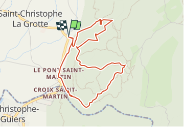
11,1 km | 17,4 km-effort
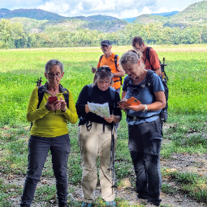
4h 43min
Ja
Tocht Wegfiets Corbel - Entreront  - Photo
Wegfiets
Geneviève Robardey

Wegfiets

Zeer moeilijk
(1)
Corbel, Auvergne-Rhône-Alpes, Savoie, France
34 km | 49 km-effort
2h 53min
Ja
Tocht Stappen Saint-Christophe - 38 st Christophe sur guiers grottes guiers vif - Photo
Stappen
GUIDE
randodyssée

Stappen

Medium
Saint-Christophe, Auvergne-Rhône-Alpes, Savoie, France
7,3 km | 12,7 km-effort
3h 24min
Ja
Tocht Stappen La Bauche - Ballade vers la Bauche - Photo
Stappen
GUIDE
nadd73

Stappen

Gemakkelijk
La Bauche, Auvergne-Rhône-Alpes, Savoie, France
11,7 km | 23 km-effort
6h 19min
Ja
Tocht sport Saint-Christophe - La grotte - Photo
sport
Biquette73

sport

Heel gemakkelijk
Saint-Christophe, Auvergne-Rhône-Alpes, Savoie, France
8,9 km | 14,1 km-effort
Onbekend
Neen
Tocht Trail Saint-Christophe - au dessus de la grotte des échelles  - Photo
Trail
GUIDE
nadd73

Trail

Heel gemakkelijk
Saint-Christophe, Auvergne-Rhône-Alpes, Savoie, France
8 km | 11,8 km-effort
1h 11min
Ja
Tocht Trail La Bauche - Mont Beauvoir  - Photo
Trail
GUIDE
nadd73

Trail

Gemakkelijk
La Bauche, Auvergne-Rhône-Alpes, Savoie, France
9,2 km | 18,7 km-effort
1h 47min
Ja
Tocht Stappen Saint-Christophe - la voie SARDE / tunnel des l'Echelles /st Christophe sur Guiers - Photo
Stappen
okfred26

Stappen

Zeer moeilijk
Saint-Christophe, Auvergne-Rhône-Alpes, Savoie, France
15,1 km | 23 km-effort
5h 12min
Ja
Tocht Stappen Saint-Christophe - 190323 Boucle voie Sarde - Photo
Stappen
mzonzon05

Stappen

Moeilijk
Saint-Christophe, Auvergne-Rhône-Alpes, Savoie, France
9,7 km | 15,6 km-effort
3h 50min
Ja


Sluiten
Mijn abonnementen